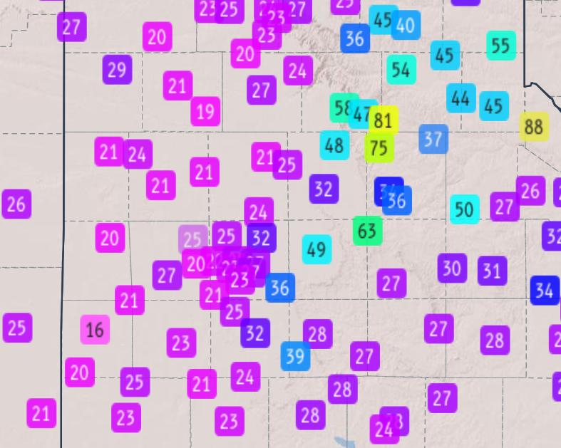
Hail described as “as large as baseballs” fell near Matador, Texas, and a West Texas Mesonet site 2 miles west-southwest of Turkey measured an 81-mph wind gust, the strongest reading in a three-day outbreak of severe storms across the Texas Rolling Plains. The largest hailstone reported measured 2.75 inches, observed 1 mile northeast of Matador in Motley County.
Help yourself and the planet: The Cool Down makes it easy to help yourself while helping the planet, with smart, simple changes to save more and waste less in your everyday life.
We may earn a commission if you sign up.
Both reports came on Tuesday, October 13, 2026, the first evening of storms that continued through midday Thursday, October 15.
2.75-Inch Hail Near Matador
The National Weather Service office in Lubbock logged the 2.75-inch stone in its event summary as a report from a cooperative observer 1 mile northeast of Matador, and wrote that hail was “as large as baseballs” near the town. The same evening produced a graduated set of reports in and around Motley County: golf-ball-size hail of 1.75 inches at Matador reported by emergency management, mPING public reports of 0.50, 1.00 and 1.75 inches 1 mile south of Matador, and 1.00-inch hail at Turkey reported by the fire and rescue department.
Hail elsewhere stayed smaller. The summary lists 0.50-inch hail at Memphis in Hall County and 0.75-inch, dime-size hail 1 mile northeast of Childress, which means the baseball-size stone near Matador was an outlier even within its own storm. The National Weather Service classes a storm as severe at hail of at least 1 inch in diameter, according to its severe weather definitions, so the 2.75-inch report cleared that threshold by nearly three times.
The source of each report matters when reading the list. The 2.75-inch stone came from a cooperative observer, a trained volunteer who reports weather for the Lubbock office, while the smaller Matador and Childress numbers came from mPING, a crowd-sourced phone app where members of the public submit what they see. Public reports are valuable for timing but are estimates, and the emergency-management and fire-department reports sit in between. Together they show a hail core that tracked through Motley and Hall counties on Tuesday evening, with the biggest stone confined to one spot rather than a wide swath of baseball-size damage.
The 81-mph Gust Near Turkey and Other Wind Reports
The peak wind report was 81 mph at the West Texas Mesonet site 2 miles west-southwest of Turkey in Hall County, where trees were downed. That mesonet is a network of more than 189 surface stations covering over 100 counties in West Texas, eastern New Mexico and Colorado, according to the West Texas Mesonet site, and its measured readings carry more weight than estimates because they come from instruments mounted at a fixed 10-meter height. The Lubbock office published a peak gust map for October 13 built from the network.
Other gusts that evening were also damaging. A mesonet site 2 miles east of Flomot in Motley County recorded 75 mph, a site 3 miles north-northwest of McAdoo in Dickens County recorded 63 mph, a site 11 miles south of Kirkland in Cottle County measured 61 mph as reported by a National Weather Service employee, and a site 6 miles northwest of White River Lake in Crosby County measured 59 mph. The criterion for a severe wind gust is 58 mph, so all five readings met or topped it, and the Turkey gust beat it by 23 mph.
Turkey appears twice in the evening’s record, which makes the town a useful marker for how the storm behaved. The fire and rescue department reported 1.00-inch hail there, large enough to qualify as severe on its own, and the mesonet gust 2 miles west-southwest of the town reached 81 mph with downed trees, according to the Lubbock summary. A storm that produces both a severe hail report and a gust 23 mph above the severe-wind threshold within a few miles is delivering wind and ice at once, which is a harder combination for crops, roofs and vehicles to ride out than either alone.
October 14 Damage Near Girard and Guthrie
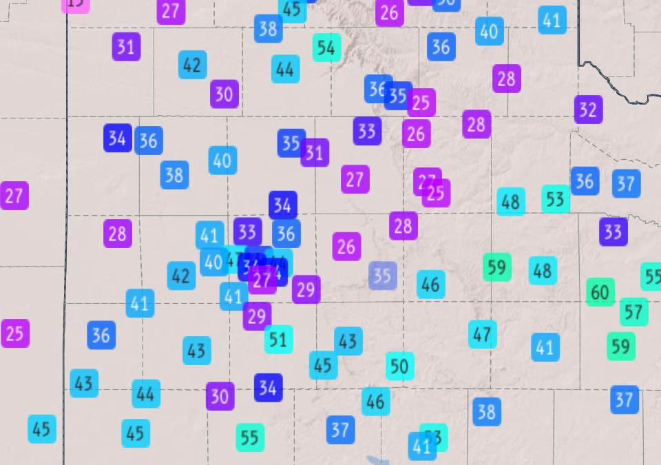
Storms kept firing the next day. On Wednesday, October 14, law enforcement reported that a roof was blown off a house and large mesquite branches were downed 7 miles west and 7 miles west-southwest of Girard in Kent County. A mesonet site 10 miles west-southwest of Guthrie in King County measured a 59-mph gust the same day, and the Lubbock office published a second peak gust map for October 14.
On Tuesday, a supercell near Dickens had produced a low-hanging wall cloud, and the severe storms of that evening gave way to the Wednesday and Thursday rounds of heavy rain that raised rivers across the region. FOX Weather had flagged a level 2 of 5 severe weather risk for West Texas, the Panhandle and Oklahoma, mainly for damaging wind gusts, before the storms arrived.
The National Weather Service keeps a live local storm report map for the Lubbock area that lists hail, wind and flood reports from the previous 24 hours. By the time it was read for this article the table was empty, but the event summary preserves the October reports with their sources.
This article was produced with the assistance of AI and reviewed by Morning Overview editors prior to publication.
Help yourself and the planet: Get The Cool Down →
We may earn a commission if you sign up.
More from Morning Overview
- Long use of a common prostate pill is tied to a higher chance of glaucoma
- Ford is recalling 223,472 F-150 pickups because the fuel tank can leak or detach
- Hybrids have 15% fewer problems than gas cars, while EVs and plug-in hybrids have about 80% more, Consumer Reports finds
- Regulators cleared the first U.S. small modular reactor, 4 months early