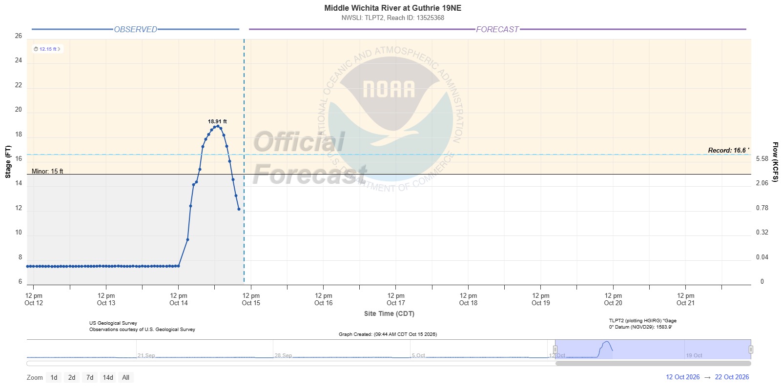
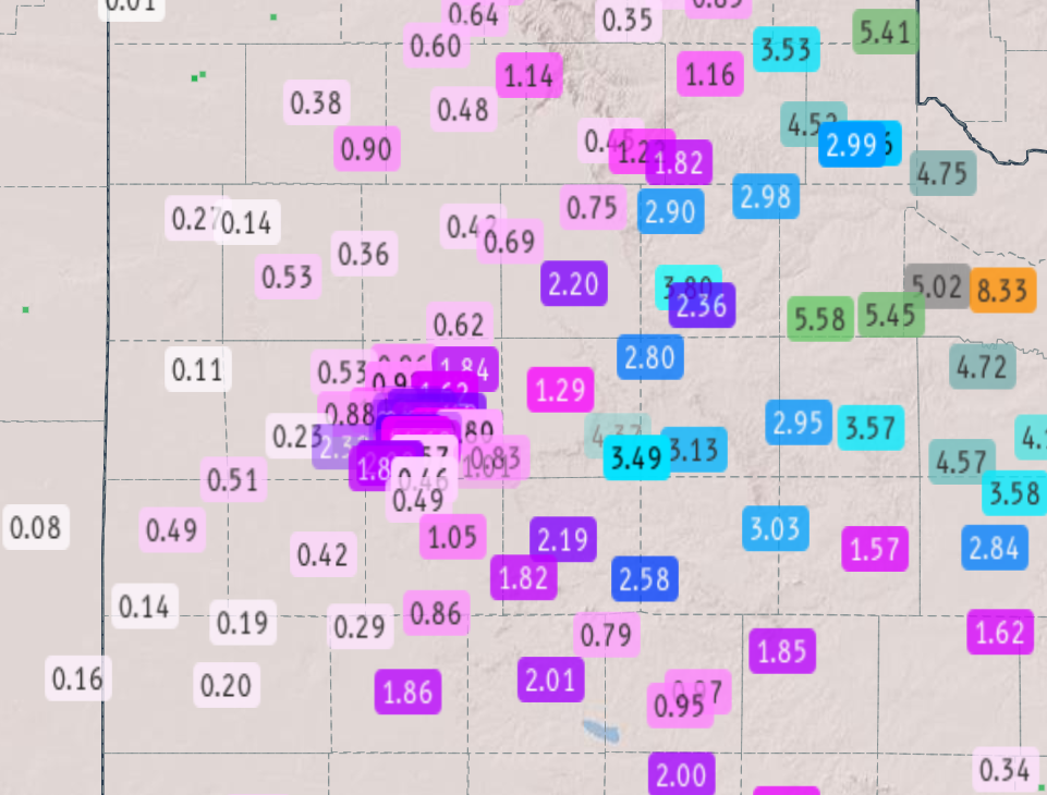
The Middle Wichita River crested at 18.91 feet at its Guthrie 19NE gauge in the Rolling Plains of West Texas during storms that ran from October 13 to October 15, 2026, passing the previous record of 16.6 feet by 2.31 feet. The river rose more than 10 feet in the process, according to the National Weather Service office in Lubbock.
Save more, waste less: The Cool Down’s newsletter sends smart, simple changes that help you and the planet in your everyday life.
We may earn a commission if you sign up.
It was the hydrologic result of three days of storms that began late on Tuesday, October 13, and lasted through midday Thursday, October 15, over ground that had little room left to absorb more water.
The Guthrie 19NE Gauge and the 16.6-Foot Record
The NWS Lubbock event summary for the mid-October storms records the crest at 18.91 feet and says it exceeded the previous record of 16.6 feet. Stage is the height of the water surface above a fixed reference level at the gauge, so the comparison measures the same point on the same river rather than two different locations. The office also published a stage plot for Middle Wichita River at Guthrie 19NE alongside the summary, showing the rise that the text describes.
The Middle Wichita was not the only stream to respond. The summary lists smaller rises on the Brazos River near Lubbock and on the South Wichita River east of Guthrie. The summary does not say which of the three rivers rose first or fastest, and it gives the Middle Wichita as the only one to set a record.
Forecast and observed river levels for Lubbock’s forecast area are published on the National Weather Service’s National Water Prediction Service page for Lubbock, the successor to the older AHPS river pages. That page showed no Guthrie gauge reading when it was read for this article, so the 18.91-foot and 16.6-foot figures rest on the Lubbock office’s event summary and its stage plot.
A record is only as old as the gauge’s period of record, and the summary does not say in which year the earlier 16.6-foot mark was set or how long the Guthrie 19NE gauge has been reporting. What it does establish is the margin: the crest beat the old mark by more than two feet, and the river climbed more than 10 feet to reach it. The summary ties the rise to rainfall of 3 to 5 inches or more across the central and northern Rolling Plains, falling on ground that earlier rounds of storms had already soaked.
Rolling Plains Rainfall and Moisture From Hurricane Simon
NWS Lubbock reported that 3 to 5 inches or more of rain fell across the central and northern Rolling Plains and into the southeast Texas Panhandle through midday Thursday. The Caprock saw swaths of 1 to 2 inches or more, and Lubbock Airport officially recorded 2.04 inches. Wednesday’s storms were the most intense over the Rolling Plains, striking in the afternoon and evening with widespread heavy rain, and Thursday’s early storms then moved east over land the summary describes as already saturated. Measured three-day totals from the West Texas Mesonet were published as a rainfall map with the same event page.
The unusual feature of the setup was the moisture. NWS Lubbock described warm, unusually moist air for mid-October, including a mid-to-upper-level tap from Hurricane Simon, which was still off the west coast of Mexico. FOX Weather had explained days earlier that a large dip in the jet stream was pulling moisture north from Simon, and it flagged a level 2 of 4 flash flood threat for parts of the Big Bend, West Texas and the Panhandle.
FOX Weather also noted that the wet weather was expected to benefit drought-affected parts of Oklahoma, southern Missouri and Texas. The Lubbock summary, however, describes a different outcome in the Rolling Plains, where the rain arrived in volumes large enough to fill dry creeks and flood roads rather than soak in slowly.
Cottle County Roads and the State Response
The flash flooding reports in the summary are dated Wednesday, October 14. NWS Lubbock described that most county roads in Cottle County flooded around Paducah and that a several-mile stretch of the main lanes of U.S. Highway 83 was closed about 6 miles south-southwest of Paducah. Farther west in Kent County, water ran over Texas 208 near Girard, over Texas 70, and over Farm-to-Market Road 1081 near Farm-to-Market Road 2320, and bar ditches were full.
The state had positioned for it before the first storm cells formed. As Fox 4 reported, Gov. Greg Abbott directed the Texas Division of Emergency Management to activate swiftwater rescue boat squads, search and rescue teams, game wardens, helicopters and highway department personnel across regions from the Panhandle to Big Bend. In a news release Abbott said Texas was prepared to respond to severe weather and flash flooding across West Texas.
This article was produced with the assistance of AI and reviewed by Morning Overview editors prior to publication.
Save more, waste less: Subscribe to The Cool Down →
We may earn a commission if you sign up.
More from Morning Overview
- Two passengers died at an Ohio toll plaza, and the NTSB now wants the cash lanes shut
- Long use of a common prostate pill is tied to a higher chance of glaucoma
- Ford is recalling 223,472 F-150 pickups because the fuel tank can leak or detach
- Hybrids have 15% fewer problems than gas cars, while EVs and plug-in hybrids have about 80% more, Consumer Reports finds