To commemorate the 200th anniversary of the Erie Canal, NASA has released a breathtaking satellite image of this historic waterway. The high-resolution image, which was featured as the space photo of the day on October 1, 2025, offers a unique perspective on the canal’s path across New York, underscoring its enduring legacy and significance today.
Historical Background of the Erie Canal

The Erie Canal, completed in 1825, revolutionized transportation and commerce in New York by connecting the Hudson River to Lake Erie. This monumental engineering feat spanned 363 miles, linking Albany to Buffalo and facilitating faster movement of goods from the Midwest to the Atlantic seaboard (source).
Over the years, the canal has undergone expansions and restorations to maintain its functionality. Today, it serves not only as a historical monument but also as a recreational hotspot and a vital irrigation source, preserving its role in the region’s history (source).
The Erie Canal’s construction was a significant undertaking, requiring the labor of thousands of workers over eight years. The canal was dug by hand, with workers using simple tools such as picks and shovels. The project was fraught with challenges, including disease outbreaks and labor disputes, but the completion of the canal marked a turning point in American history, transforming New York into the Empire State (source).
Moreover, the Erie Canal played a crucial role in the westward expansion of the United States. It opened up new trade routes and facilitated the movement of people and goods, contributing to the economic development of the Midwest. The canal’s success also inspired the construction of other canals across the country, marking the beginning of the canal era in America (source).
NASA’s Role in the Anniversary Celebration

NASA’s involvement in the Erie Canal’s bicentennial celebration is a testament to the agency’s commitment to using space technology for educational and cultural purposes. By capturing and sharing the satellite image of the canal, NASA aims to inspire a sense of awe and curiosity about our planet’s history and its interconnectedness with space exploration (source).
Furthermore, NASA’s participation in the celebration underscores the agency’s role in promoting scientific literacy and public engagement in science. The satellite image of the Erie Canal serves as a powerful tool for educators, providing a tangible example of how space technology can be used to study and appreciate our cultural heritage (source).
Details of the Satellite Imagery
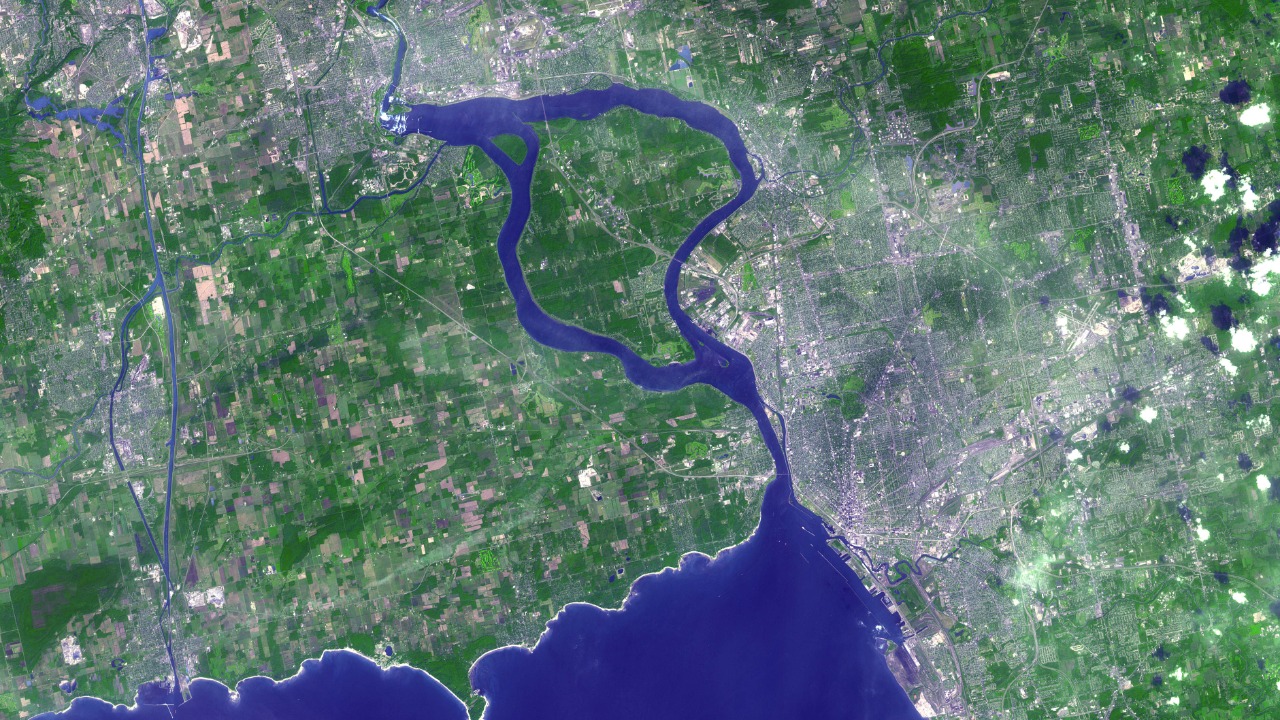
The satellite image reveals the Erie Canal’s 200-year-old structure in high detail, highlighting locks, aqueducts, and surrounding urban development from space. The image emphasizes the canal’s visibility against the landscape, showcasing its engineering feats (source).
The satellite image of the Erie Canal is a testament to the advancements in space technology over the past few decades. The image was captured using multispectral imaging, a technique that collects and processes light from different parts of the electromagnetic spectrum. This technology allows scientists to observe features that would be invisible to the naked eye, such as changes in vegetation and water quality along the canal’s route (source).
Furthermore, the satellite image provides a unique perspective on the canal’s relationship with its surrounding environment. The image reveals how the canal has shaped and been shaped by the landscape over the past two centuries, offering valuable insights into the interplay between human activity and natural processes (source).
The Erie Canal’s Modern Significance

Two centuries after its completion, the Erie Canal continues to play a significant role in the region. It supports tourism, with over 150,000 boaters annually navigating its waters for recreational purposes (source).
The canal’s path, visible in the satellite images, also demonstrates its role in flood control and water management for communities in New York State. Furthermore, NASA’s imagery highlights how the canal influences local biodiversity, with satellite data showing vegetation patterns and urban encroachment over two centuries (source).
Today, the Erie Canal is a testament to the ingenuity and perseverance of the early American settlers. It stands as a symbol of America’s industrial past and a reminder of the transformative power of infrastructure projects. The canal’s continued operation also contributes to the local economy, generating revenue through tourism and recreational activities (source).
Moreover, the Erie Canal serves as an important case study for environmental scientists and urban planners. The canal’s history offers valuable lessons on the environmental impacts of large-scale infrastructure projects and the importance of sustainable development. The satellite images captured by NASA will continue to provide valuable data for researchers studying these issues (source).
Broader NASA Space Imaging Efforts
NASA’s imaging efforts are not limited to capturing stunning views of celestial bodies and human-made landmarks. The agency also uses its space-based assets to monitor Earth’s climate and environmental changes. These observations provide critical data for scientists studying global warming, deforestation, and other environmental issues (source).
Moreover, NASA’s space imaging efforts contribute to disaster management and emergency response. By providing real-time images of natural disasters such as hurricanes and wildfires, NASA helps authorities make informed decisions and coordinate relief efforts. This demonstrates the wide-ranging applications of space technology and its potential to address pressing global challenges (source).
Future Implications of Satellite Monitoring
Ongoing NASA satellite missions will continue tracking changes to the Erie Canal, monitoring erosion and climate impacts on its 200-year-old infrastructure. The 2025 anniversary imagery sets a precedent for using space technology to preserve cultural heritage sites, with potential applications to other U.S. landmarks (source).
Advances in satellite resolution, inspired by projects like Chandra, could enhance future Erie Canal observations, aiding conservation efforts. As we continue to explore the cosmos, we also deepen our understanding of our own planet, using technology to preserve and study our shared cultural heritage (source).
The future of satellite monitoring holds immense potential for cultural preservation and environmental conservation. As satellite technology continues to advance, we can expect more detailed and accurate images of our planet’s surface. These images will not only help us understand our past but also guide our future actions, informing policy decisions and conservation strategies (source).
Moreover, satellite monitoring could play a crucial role in preserving other cultural heritage sites around the world. By providing a bird’s-eye view of these sites, satellites can help detect threats such as erosion, urban encroachment, and climate change. This could lead to more proactive and effective preservation efforts, ensuring that our cultural heritage is passed on to future generations (source).