Mesopotamian clay maps, dating back 5,000 years, provide a fascinating glimpse into the ancient world’s perception of geography, particularly its rivers. These clay tablets not only depict the physical landscape but also offer insights into the cultural and mythological significance of these waterways. As archaeological discoveries continue, these maps reveal more about how early civilizations understood and interacted with their environment.
The Historical Context of Mesopotamian Maps
Often referred to as the “Cradle of Civilization,” Mesopotamia was pivotal in the development of early cartography. Situated between the Tigris and Euphrates rivers, this region was home to some of the earliest human settlements and city-states. This prime location fostered the exchange of ideas and innovations, leading to the development of early mapping techniques. The importance of Mesopotamia in shaping civilization is evident in its contributions to writing, law, and urbanization, all of which played a role in the evolution of map-making.
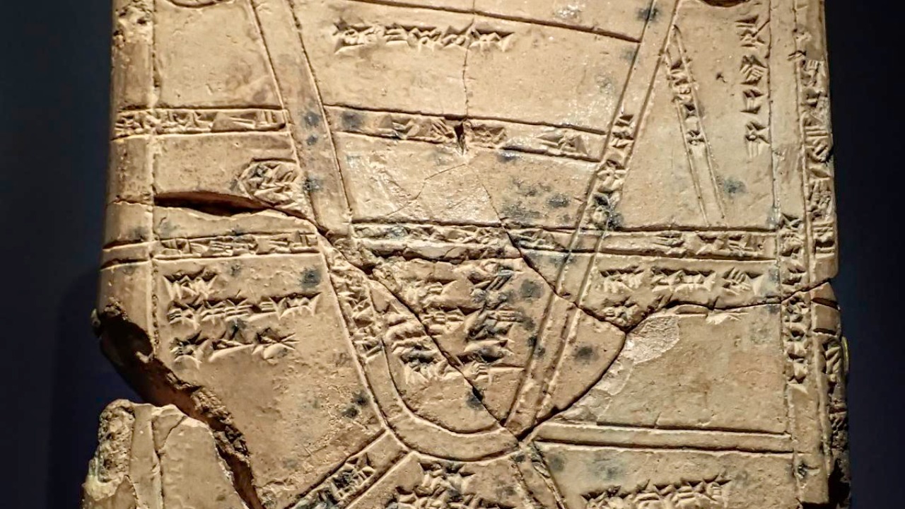
Clay tablets were the primary medium for record-keeping and map-making in Mesopotamia. The abundance of clay in the region made it an accessible resource for creating durable records. These tablets, inscribed with cuneiform script, served multiple purposes, including documenting trade transactions, religious texts, and geographical information. The unique properties of clay allowed for detailed and lasting impressions, preserving the maps for millennia.
The early mapping techniques employed by Mesopotamians were simple yet effective. They used basic tools like styluses to etch into the clay, depicting rivers, mountains, and cities with symbolic representations. The maps were more than just geographical guides; they reflected an understanding of the world that intertwined with the Mesopotamians’ cultural and religious beliefs. Despite the absence of modern tools, these early cartographers created maps that were instrumental in shaping their society’s understanding of their environment.
Significance of Rivers in Mesopotamian Culture
Rivers played an essential role in the economic prosperity of ancient Mesopotamia. The Tigris and Euphrates rivers provided fertile land for agriculture, allowing the growth of crops that supported cities and trade networks. These waterways facilitated the transportation of goods and people, connecting distant regions and fostering economic exchange. The rivers’ significance in trade and agriculture is a testament to their vital role in shaping settlement patterns and sustaining the Mesopotamian economy.
Beyond their economic importance, rivers held a profound place in Mesopotamian mythology and religious practices. They were often depicted as divine entities or associated with gods and goddesses who controlled their flow and fertility. For example, the Euphrates was linked to the god Enki, who was revered as a deity of water and wisdom. The rivers were seen as life-giving forces, and their presence in religious texts and rituals underscores their spiritual importance in Mesopotamian culture.
Rivers also served as natural boundaries, influencing political relationships between city-states. The Tigris and Euphrates acted as dividing lines that separated territories and defined spheres of influence. These natural borders often dictated the alliances and conflicts between neighboring states, shaping the political landscape of ancient Mesopotamia. The strategic importance of rivers as boundaries highlights their role in the region’s social and political history.
Deciphering the Ancient Clay Maps
Archaeologists have uncovered several significant finds that shed light on Mesopotamian maps. One such discovery is the Babylonian Map of the World, considered one of the oldest known maps. This clay tablet, dating back to the 6th century BCE, provides a schematic view of the world as understood by the Babylonians. It features a circular depiction of the earth surrounded by water, with Babylon at its center, illustrating the centrality of this city in their worldview.
Interpreting these ancient maps poses challenges for historians. The symbolic nature of the maps, combined with the intricacies of cuneiform script, requires careful analysis and expertise. Additionally, the passage of time has led to the erosion and damage of many tablets, complicating efforts to decipher them. Despite these challenges, advances in technology, such as imaging and 3D modeling, have significantly aided researchers in analyzing these artifacts. These tools allow for detailed examination and reconstruction of the maps, providing new insights into Mesopotamian geography.
Modern technology has also facilitated the preservation of these ancient maps. Techniques like digital imaging have allowed for the creation of high-resolution replicas, ensuring that the information contained within these tablets is accessible to future generations. This intersection of ancient artifacts and modern technology exemplifies the ongoing efforts to uncover and understand the complexities of Mesopotamian cartography.
Comparative Analysis with Other Ancient Maps
When comparing Mesopotamian maps with those of other ancient civilizations, such as Egypt and Greece, distinct differences in style and content emerge. While Egyptian maps often emphasized religious and funerary aspects, Greek maps were more focused on exploring the known world and its boundaries. Mesopotamian maps, in contrast, combined geographical and cosmological elements, reflecting a worldview that intricately linked the physical and spiritual realms.
The influence of Mesopotamian cartography on later map-making traditions is evident in the way these early maps laid the groundwork for more sophisticated techniques. The concept of symbolic representation and spatial organization seen in Mesopotamian maps can be traced through subsequent cartographic developments. As civilizations interacted and exchanged knowledge, the foundational principles established by Mesopotamian cartographers continued to inform and inspire future generations.
One of the unique features of Mesopotamian maps is their integration of mythological elements with geographical depictions. For instance, the famed depiction of Noah’s Ark on a Babylonian map illustrates the fusion of cultural narratives with geographic knowledge. These maps were more than just tools for navigation; they were expressions of a civilization’s understanding of the cosmos and its place within it.
The Legacy of Mesopotamian Cartography
The study of Mesopotamian maps has made significant contributions to modern geographical knowledge. By examining these ancient artifacts, researchers have gained insights into early methods of spatial representation and the cultural factors shaping them. This understanding enriches our comprehension of human history and the evolution of geographic thought, highlighting the enduring impact of Mesopotamian innovations.
Preserving these artifacts is crucial for maintaining our cultural heritage and ensuring that future generations can learn from them. The clay maps of Mesopotamia offer valuable lessons about the interconnectedness of geography, culture, and history. Efforts to conserve these tablets are essential for safeguarding the insights they provide into the development of human civilization.
Ongoing research continues to explore the depths of Mesopotamian cartography. Scholars and archaeologists are actively engaged in uncovering new artifacts and re-evaluating existing ones, using contemporary techniques to enhance our understanding of these ancient maps. Future directions in this field promise to reveal even more about the sophisticated ways in which Mesopotamians perceived and interacted with their world. As we delve deeper into the past, the legacy of these early maps serves as a testament to human ingenuity and the enduring quest to understand our place in the world.