Hydrogen bombs turned remote coral atolls into proving grounds, and the blast waves have never really stopped. In the Marshall Islands and across the wider Pacific, the fallout still shapes landscapes, bodies, and politics long after the last mushroom cloud faded from the sky. The story of these islands is not just about past tests, but about a present defined by radioactive soil, fragile concrete domes, and communities still fighting to be heard.
The United States ended its nuclear testing program in the Marshall Islands in 1958, yet generations later the islands remain a case study in how a few years of detonations can rewrite a nation’s future. From Bikini and Enewetak to Kiritimati, the legacy of hydrogen bombs is etched into contaminated lagoons, cancer statistics, and diplomatic negotiations that continue today.
Bikini Atoll: Ground zero that never healed
The Marshall Islands became a centerpiece of the early nuclear age when the United States selected its remote atolls for a series of atmospheric tests. Official records note that testing in the Marshall Islands ended in 1958, but the end of detonations did not end the damage. At Bikini Atoll alone, the U.S. carried out 23 nuclear tests between 1946 and 1958, displacing residents and seeding long term health problems that still shape negotiations between Washington and island leaders, as recent reporting on Bikini Atoll makes clear. The Bikini Atoll in the Marshall Islands is now widely described as one of the most contaminated places on Earth, a place where the Cold War’s technical triumphs translated into permanent exile for its original inhabitants, according to detailed accounts of Nuclear Tests and.
The Environmental Contamination of Bikini Atoll is not an abstraction but a measurable reality in its soil, coconuts, and lagoon. Analysts describe how the nuclear tests left Bikini Atoll badly contaminated, and even today it is one of the most radioactive places in the world, with lingering isotopes that complicate any attempt at safe resettlement, as outlined in assessments of the Environmental Contamination of. The United States has paid more than $300 m into various trust funds to compensate the islanders and their descendants, with some reports also citing the figure as $300 million, yet those sums have not erased the reality that the land itself remains hazardous, a point underscored in documentation of how The United States has tried to address the damage.
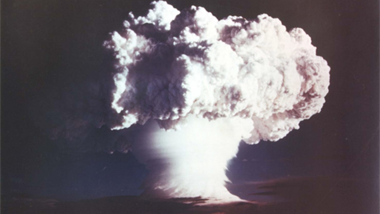
Castle Bravo and the physics of obliteration
The most infamous of these detonations was Castle Bravo, a hydrogen bomb test that redefined what “too powerful” meant in nuclear planning. One of the most famous tests was One of the largest explosions ever carried out by the United States, and its fallout cloud spread across nearby islands and even reached Japan. The blast did not just scar the test site, it turned entire islands into vapor, leaving behind craters that still gape in the reef. Reports on Castle Bravo describe how the explosions vaporized entire islands, leaving large craters in their place, and how radioactive contamination made the land uninhabitable even where the physical geography survived.
What happened at Bikini Atoll also foreshadowed the destructive logic of later nuclear planning, including concepts like “bunker buster” weapons that would detonate just below the surface. Technical analyses explain that a shallow subsurface nuclear explosion produces a large crater, obliterating facilities within its radius and any just beyond it where strong stresses rupture the earth, a pattern that mirrors what islanders saw when hydrogen bombs tore open their atolls, as described in research on a shallow subsurface blast. For the people of the Pacific, these were not theoretical diagrams but lived experience, as shock waves shattered homes, coral, and any illusion that the tests were safely contained.
Life after nuclear testing: exile, illness, and unfinished justice
For displaced families, the end of testing marked the beginning of a long and uncertain search for home. Life After Nuclear Testing, Bikini Atoll and Its Legacy Bikini Atoll is often described as a once peaceful and beautiful Pacific Island that became a nuclear test site, with fallout that reshaped both the island’s environment and its people, according to accounts of Life After Nuclear. The process of repopulating Bikini Atoll has been slow, and many families continue to live on other islands in the Marshall Island chain, a reminder that the social fabric torn by evacuation has never been fully repaired, as described in narratives about how Bikini Atoll remains largely empty of its original community.
The nuclear legacy in the Pacific is a stark reminder that geopolitical decisions made far away can leave scars that last generations, from cancers and birth defects to environmental degradation from tests conducted decades ago. Survivors and their descendants across the Pacific now frame their demands not only as a call for compensation but as a push for a global ban on nuclear weapons testing and use. Their argument is simple and rooted in lived evidence: if a few dozen tests could permanently displace communities and poison food chains, then any future use would be catastrophic on a scale that no treaty payment could ever balance.
Enewetak Atoll and the ticking time bomb of Runit Dome
If Bikini Atoll is the symbol of open air detonations, Enewetak Atoll is the symbol of how the world tried, and failed, to bury the problem. Forty-three atmospheric nuclear tests were conducted at Enewetak Atoll between 1948 and 1958, with a combined explosive yield equivalent to 31.7 million tons of high explosives, a staggering figure documented in technical histories of Forty. The debris stems from nuclear tests conducted in the Enewetak Atoll by the United States between 1946 and 1958, and from 1977 to 1980 workers scraped contaminated soil and equipment into a blast crater created by the Cactus test, turning Runit Island into a nuclear landfill, as chronicled in records on Enewetak Atoll.
During the late 1970s, the U.S. government built an aboveground, concrete-covered nuclear waste storage site, Runit Dome, about 350 miles from the main population centers, sealing radioactive material under a thin shell that was never designed for rising seas, as detailed in investigations that describe how During the cleanup, waste was pushed away on Runit Island in Enewetak Atoll. Runit Dome In 1977-1980 the crater created by the Cactus shot of Operation Hardtack I was used as a burial pit to inter 84,000 cubic meters of radioactive debris, and the Dome was built to cover the material, a scale of containment that still leaves islanders uneasy, as described in detailed accounts of Runit Dome In.
On tiny Runit Island, part of Enewetak Atoll, sits “the dome,” a structure 377 feet in diameter and 115 meters across, made of concrete above a crater that was never lined, a design that critics say was more about speed than permanence, as described in recent coverage of Runit Island. Public Health experts who studied Radiological cleanup At Enewetak Atoll note that from 1948 to 1958 the U.S. conducted 43 nuclear tests on the Enewetak Proving Ground, and that veterans involved in the cleanup may face possible health risks if they had exposure to radiation, a concern that extends to current residents living near the site, as outlined in official summaries of Radiological.
More from Morning Overview