Far below the frozen surface of Antarctica, scientists are uncovering a landscape that looks less like a featureless ice cap and more like a buried continent, complete with mountains, valleys, rivers and long‑vanished ecosystems. Using a new generation of satellite measurements, radar and painstaking drilling, researchers are now resolving this hidden world in unprecedented detail, revealing a terrain that has been sealed off for tens of millions of years and could shape the planet’s future as much as its past.
The emerging picture is of a dynamic, rugged underworld that channels ice, stores water and preserves a “time capsule” of ancient climates. What had once been treated as a blank white space on the map is turning into a crucial laboratory for understanding how ice sheets behave, how sea levels will rise and how Earth responded the last time carbon dioxide and temperatures surged.
The most detailed portrait yet of Antarctica’s buried landscape
Researchers have now assembled the most detailed map so far of the bedrock beneath Antarctica, revealing ancient mountains, lakes and rivers that had been completely hidden under the ice. By combining satellite imagery with advanced techniques such as IFPA, the new work shows a complex network of subglacial features that includes long mountain chains and deep basins, all buried beneath the continent‑scale ice sheet that defines Antarctica today. One of the most striking findings is a huge ancient river system that once drained a landscape very different from the frozen desert we see now.
The new mapping effort resolves the landscape in far finer detail than earlier reconstructions, turning what used to be broad guesses into specific ridges, valleys and basins. A companion analysis of the landscape beneath the ice describes a richly textured terrain that has already drawn at least 609 public Comments, a reminder of how powerfully this hidden world captures the imagination. For scientists, the appeal is practical as well as visual, since every new contour helps refine models of how ice flows and where it might retreat.
A “lost world” frozen in time for tens of millions of years
What makes this buried terrain so compelling is not only its shape but its age. Deep beneath almost two kilometers of ice, researchers have identified an enormous landscape that appears to have been untouched since ancient times, a kind of fossilized topography preserved under the Deep freeze of the Antarctic interior. Airborne radar, fired through the ice and bounced off the bedrock, has revealed valleys and plateaus that have not seen the open sky since long before humans evolved, giving scientists a rare snapshot of a pre‑glacial world.
Drilling projects have gone further, suggesting that parts of this terrain preserve a “lost world” that has been isolated for roughly 34-million-year intervals. In one study, cores taken from a site Buried under 2 km of Antarctic ice captured sediments and microfossils that record conditions before the ice sheet formed, effectively sealing and preserving an ancient environment. A related analysis of material Buried beneath kilometers of Antarctic ice points to a 34-million-year-old lost ecosystem, while another report describes a lost world 34 m years old, repeating the figure of 34 m in separate accounts of the same discovery. A broader synthesis notes that a Lost World Has 34 Million Years, reinforcing the idea that this terrain has been locked away for over 34 M years.
From Mars comparisons to “Mysterious Pink Rocks”
For decades, scientists joked that the surface of Mars was better mapped than the bedrock under the Antarctic ice sheet, and recent work confirms how quickly that gap is closing. Researchers now argue that the subglacial terrain of Antarctica is finally being charted with a level of detail once reserved for Mars, revealing mountains, valleys and some 30,000 unseen hills that had never appeared on any previous map. Traditionall, scientists relied on sparse radar transects and isolated field campaigns, but the new synthesis stitches those fragments into a coherent picture that can guide everything from basic geology to climate policy.
Some of the most intriguing clues to this hidden architecture come not from satellites but from rocks that have somehow escaped the ice. In one study, geologists traced a set of Mysterious Pink Rocks a Massive Secret Buried Under Antarctica, using Ancient granite boulders to infer the presence of a vast hidden structure beneath the Ice. These boulders, carried to the surface by glacial motion, act like geological messengers from below, hinting at the size and composition of the crust that supports the ice sheet and helping to explain how that crust has flexed and warped as the ice has grown and shrunk.
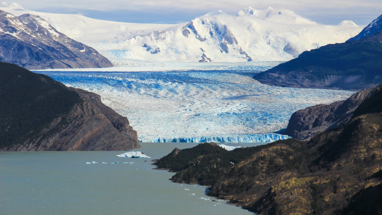
Rivers, valleys and an alpine world under the ice
Far from being flat, the bed beneath the ice is carved into an intricate network of valleys and channels that behave much like river systems on the surface. Radar surveys show that Antarctica‘s Secret Landscape Underneath a vast ice sheet includes alpine valleys and ice rivers stretching between 1.2 miles and 18.6 miles, forming a rugged relief more reminiscent of mountain ranges elsewhere on Earth than of a featureless polar plateau. These valleys funnel ice toward the coast, controlling how quickly glaciers can accelerate when they lose their buttressing ice shelves.
Scientists have also identified a complex system of subglacial waterways that move meltwater beneath the ice, lubricating its base and sometimes triggering rapid flow. Earlier work showed that Antarctica‘s massive ice sheet looks deceptively smooth from above, even though it rises 13,400 feet above sea level near its highest points and hides a labyrinth of rivers and lakes below. As unprecedented warmth reaches the continent, scientists now predict that as more meltwater percolates through this system, the hidden hydrology cloaked beneath Antarctica’s ice sheets will play an increasingly important role in how quickly ice can slide toward the ocean.
Why this buried world matters for future sea level
The new maps are not just cartographic achievements, they are essential tools for predicting how the ice sheet will respond to continued warming. Thanks to satellites, scientists already had a good understanding of the icy surface, but what lay beneath remained more obscure until recent work began to resolve the landscape in detail. By combining those data with targeted drilling and radar flights, teams have started to fill in the gaps, even though, as one researcher put it, the barren landscape is intimidatingly vast and field missions can be separated by dozens of miles. That challenge has driven the use of new techniques described in accounts of a hidden landscape, where scientists stitch together sparse measurements to infer the continent’s subsurface features.
Those features feed directly into global sea level forecasts. Accurate predictions of sea level rise require a fundamental understanding of the controls on Accurate Antarctic grounded ice sheets, as well as the floating ice that extends from them, because the shape of the bedrock determines how easily warm ocean water can reach the ice front and how quickly glaciers can retreat. That is why scientists have invested in a New map of Antarctica that reveals a hidden world of lakes, valleys and mountains buried beneath miles of ice, and why other teams are using remote sensing to show how scientists have mapped the bedrock to understand how the ice sheet might change in response to warming. A related effort, described in reports that Scientists Uncover Secret, underscores how each new discovery about the Ice and its buried topography feeds directly into models that coastal planners and governments will rely on in the decades ahead.
Supporting sources: New map reveals, Buried under 2.
More from Morning Overview