Fresh forecast maps for the January 2026 United States winter storm show the system bending sharply north at the last minute, a shift that drags tens of millions of additional people into the bull’s-eye. Instead of a narrowly southern event, the evolving track now points toward a sprawling corridor of crippling snow, ice and brutal cold from the southern Plains to New England. The change is turning what was already a high‑impact storm into a potentially defining weather event of the season.
Meteorologists now warn that this storm could deliver some of the heaviest snow in decades to major cities while unleashing a dangerous ice belt across parts of the South and Mid South. With model guidance still adjusting and local alerts ramping up, I am watching a fast‑moving situation where a few hundred miles of Track change could mean the difference between a cold rain and life‑threatening ice.
The storm that grew into a continental threat
What began as a powerful winter system organizing over the Pacific has evolved into the January 2026 United States winter storm, a sprawling cyclone expected to sweep from New Mexico to Maine. Meteorological analyses show the storm tapping deep Gulf moisture and colliding with Arctic air, a setup that favors widespread heavy snow, sleet and freezing rain across much of the country, with impacts projected from the southern Plains through the Appalachia region and into the far Northeast as northeastern Maine. That broad footprint is why forecasters describe it as a major, long duration event rather than a quick‑hitting blizzard.
Seasonal outlooks from federal climate forecasters had already highlighted an active pattern, and the current system is now emerging as the most impactful winter storm so far this season. Guidance from the Climate Prediction Center had flagged the risk of cold outbreaks and stormy conditions, and this event is now fulfilling that signal. In detailed Major briefings, forecasters emphasize that the combination of snow and ice, not just totals in any one place, is what makes this storm so dangerous.
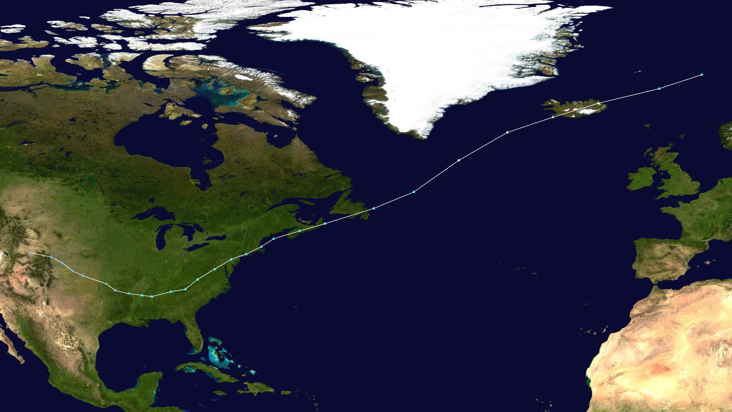
How the Track jumped north overnight
The most dramatic development in recent days has been the abrupt northward jump in the projected Track, a change that caught even seasoned meteorologists off guard. Ensemble guidance that samples many possible outcomes showed a wide spread earlier in the week, but as new data from the storm poured in, the consensus shifted, pulling the core of heavy precipitation and cold air hundreds of miles closer to the Ohio Valley and Northeast. That evolution is captured in Regionwide ensemble products, which highlight how quickly uncertainty narrowed around a more northern solution.
On social media, one prominent forecaster summarized the shift with a blunt assessment that MODELS SHIFT NORTH OVERNIGHT, describing a Huge jump in storm track of as much as 200 miles. That language, captured in a MODELS post, reflects how unusual it is to see such a large relocation of the axis of heaviest snow so close to the event. National guidance has echoed that message, with one detailed Track discussion warning that the northward trend carries huge implications for who sees feet of snow versus a glaze of ice.
New maps, New risks: who is now in the bull’s‑eye
The latest winter storm maps, updated as the Track bent north, now show a corridor of heavy snow and ice stretching from the southern Plains through the Midwest, South and New England. Forecast graphics highlight Snow, sleet and ice expanding across Texas, Louisiana and Mississippi on Saturday, then arcing toward the Ohio Valley and interior Northeast as the system matures. That evolution is laid out in detailed Saturday forecasts, which stress that even a slight wobble could shift the snow and ice line for millions.
Fresh national graphics circulated by forecasters show the storm beginning in the southern Plains on Friday before sweeping across the South and East Coast, bringing Heavy snow and accumulating ice to a vast swath of the country. Those maps now align with warnings that more than 150 million people could be affected, including Major metro areas such as Dallas, Austin, Oklahoma City, Nashville and Atlanta, where travel and power infrastructure are highly vulnerable. One detailed outlook notes that snow totals in some interior zones are preliminarily slated at 30 inches, underscoring the scale of the threat across the Major corridor now under the gun.
From Texas ice to NYC’s biggest snow in decades
Closer to the ground, the northward Track has sharpened the contrast between a crippling ice storm in the South and blockbuster snow farther north. In Texas, forecasters now expect a crippling ice storm from Texas through parts of the South, potentially around a foot of snow in colder pockets and dangerous glaze where temperatures hover near freezing. That scenario is detailed in national coverage of the massive system, which warns that the same storm could also bury parts of Minnesota and North Dakota as it wraps up on the northern flank of the Texas to Boston corridor.
Farther east, the same shift has dramatically raised the stakes for the Northeast. While earlier projections kept the heaviest snow inland, updated guidance now shows the NYC region bracing to be pommeled with the most snow in decades, with New York City facing the prospect of paralyzing accumulations and coastal flooding as the storm deepens offshore. One detailed NYC briefing notes that the city could see its biggest storm in a generation, while regional outlooks for the Northeast warn that much of the region has the potential to pick up a whopping 2 feet of snow if the Track holds. That risk is highlighted in updated Northeast projections that now place major population centers squarely in the heavy snow band.
Why forecasters were confident, yet cautious
Even as the maps shifted, meteorologists had long signaled that a high impact event was likely, framing this as NOAA’s Winte season showcase storm. In a detailed explainer, forecaster Rachel Duensing, who is Posted by name in one widely shared briefing, describes how a major winter storm is set to impact a large swath of the U.S. and warns that parts of the country could see catastrophic levels of accumulating ice. Those warnings, tied to Posted guidance from NOAA and the National Weather Service, help explain why emergency managers began ramping up days before the exact Track was locked in.
At the same time, forecasters were transparent about the remaining uncertainty, urging people from New Mexico to Maine to monitor updates closely. One national overview notes that the storm is expected to bring widespread heavy snow, sleet and freezing rain from New Mexico to Maine from Jan. 23 to Jan. 26, but adds that while confidence is high in a major event, local forecasts should be closely monitored for updates. That balance of confidence and caution is reflected in public messaging that encourages residents to prepare now while acknowledging that small Track changes can still shift the axis of heaviest impacts, a point underscored in a detailed New Mexico briefing.
More from Morning Overview