A Cold War nuclear bunker on the Yorkshire coast, built to track the unthinkable, is now itself on the brink of destruction. Perched on a rapidly eroding cliff near Tunstall, the former observation post is reported to be only days away from crashing onto the beach below as the North Sea eats away at the land that once concealed it.
The structure, designed to withstand the shockwaves of nuclear attack, has proved no match for decades of coastal erosion that have turned this stretch of East Yorkshire into one of the fastest retreating shorelines in Europe. Its imminent fall is a stark, almost cinematic image of how the physical remnants of the Cold War are colliding with a very modern environmental crisis.
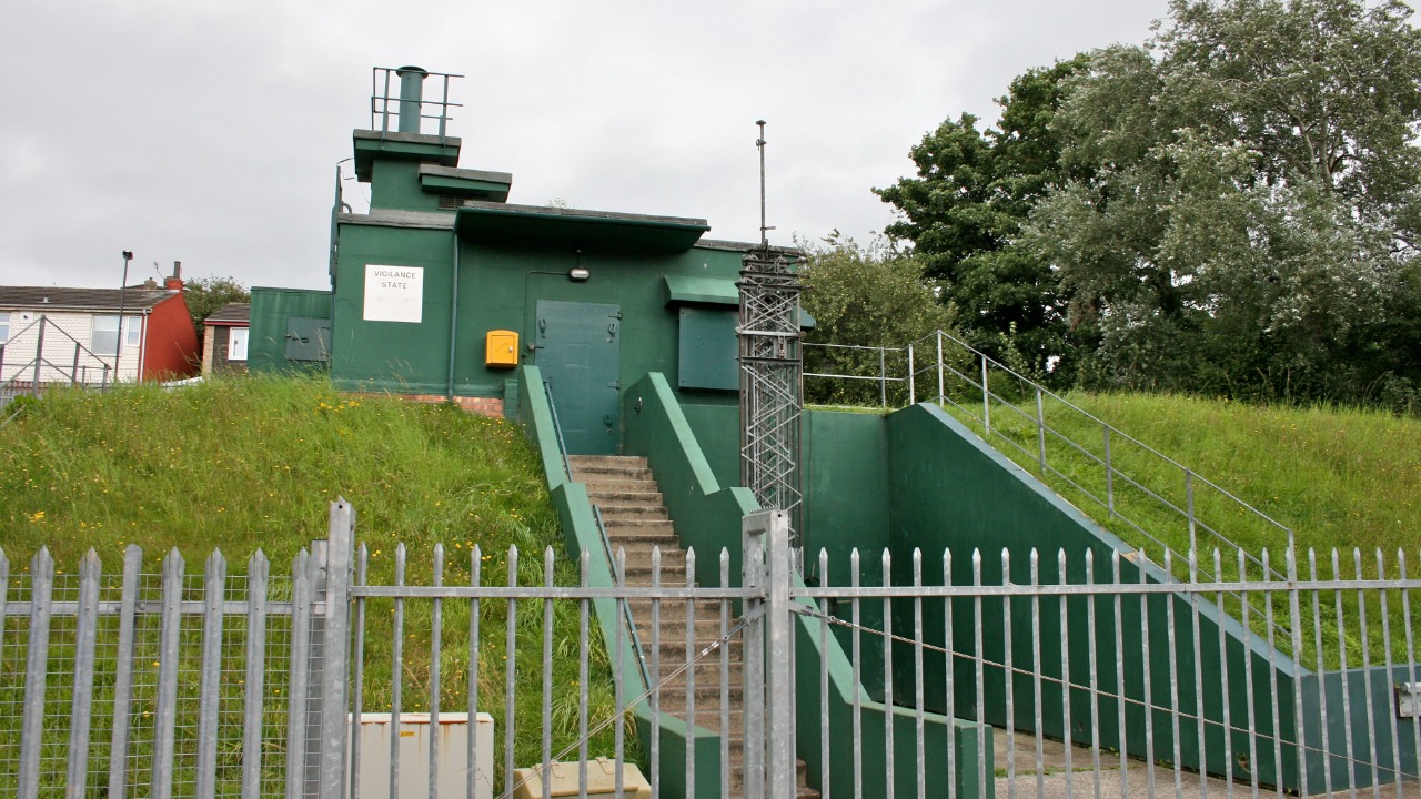
The Cold War outpost now hanging over the beach
The bunker sits above Tunstall beach, where the cliff has been cut back so far that the concrete entrance and surrounding ground now jut out over empty air. The Cold War nuclear observation post is described as clinging to the cliff face, with local observers warning it is only a few days away from being claimed by the sea as the edge continues to crumble beneath it, a situation captured in vivid detail in recent reports. What was once a discreet defensive asset is now an exposed relic, its vulnerability visible from the sand below and from the coastal path above.
The post was part of a wider network of sites built across Britain to monitor nuclear blasts and fallout, and its location on the East Yorkshire coast was chosen for strategic visibility rather than long term stability. As the sea has advanced, the surrounding land has been stripped away, leaving the bunker’s concrete shell and access shaft hanging over a sheer drop. The Cold War nuclear observation post above Tunstall is now described as only “a few days away” from collapse, a phrase that has turned an obscure local feature into a symbol of how quickly the coastline is changing, as highlighted in detailed coverage of the Tunstall site.
Inside a Royal Observer Corps time capsule
Although it now looks like a simple concrete box on the cliff edge, the structure was commissioned and operated by the Royal Observer Corps and formed part of the United Kingdom’s Cold War civil defence network. Beneath the surface, two compact chambers were created for short term use, typically manned by volunteers who would have been expected to monitor nuclear detonations and fallout patterns from within this confined space, according to detailed descriptions of the Royal Observer Corps post. The design was brutally functional, with a vertical ladder, a small monitoring room and basic living provisions intended to keep a tiny crew operational for a limited period after an attack.
Accounts of the layout describe a narrow entrance shaft leading down to those two rooms, which were never meant for comfort but for endurance and data gathering. Beneath the ground, the compact chambers would once have housed instruments to measure blast pressure and radiation, along with bunks and rations for the volunteers who trained to use them. That subterranean world is now exposed to the elements as the cliff falls away, and the description of the interior as “Beneath the surface, two compact chambers” has become a reminder that this was a human workplace as well as a military asset, as set out in coverage that details how the chambers were arranged.
Coastal erosion turning history into debris
The bunker’s predicament is not an isolated quirk of geography but part of a wider pattern of rapid coastal erosion along this stretch of East Yorkshire. The Environment Agency identifies East Yorkshire as one of the fastest eroding coastlines in Europe, with the soft boulder clay cliffs retreating at a rate that has already claimed farmland, roads and holiday homes, a trend that has now reached this Cold War relic according to assessments of the surrounding land. Local observers say the bunker’s movement is a visible marker of how quickly the cliff line is shifting, turning abstract erosion statistics into something people can see sliding toward the sea week by week.
Residents and visitors have described watching cracks open in the ground around the structure and seeing fresh slices of cliff peel away after storms, leaving the bunker more exposed each time. One observer, speaking as the site was filmed, remarked that “this whole area is eroding at a rapid rate” and that seeing a solid structure inching toward collapse shows what is happening to the coastline more broadly, a sentiment captured in video shared alongside footage of the bunker. The approaching fall of the post is therefore not just a curiosity for history buffs but a live case study in how climate driven coastal change is reshaping communities and landscapes.
Warnings, cordons and a race against curiosity
As the cliff has deteriorated, local authorities have moved to keep people away from the edge, warning that the ground around the bunker could give way without notice. The council has urged people to avoid the area and not to cross safety barriers for a closer look, stressing that the combination of unstable clay, undercut cliffs and the weight of the concrete structure makes the site particularly hazardous, a message reinforced in public appeals that accompany images of the bunker hanging over the drop. Officials have framed the risk in blunt terms, saying the bunker is only “a few days away” from collapse and that anyone venturing too close could be caught in a sudden landslip.
Despite those warnings, the bunker has become a magnet for sightseers and content creators who want to capture its final days before it falls. One of the most widely shared views has come from an amateur historian whose YouTube live stream of the site has been watched by thousands, turning the decaying post into an unlikely online spectacle as viewers wait to see when it will finally drop, a phenomenon described in coverage of the live stream. I see in that tension between safety advice and viral curiosity a familiar pattern in how we respond to slow motion disasters, treating them as both warnings and entertainment.
What the bunker’s fate says about memory and risk
The Tunstall shelter was never used in anger, and those who served in the Royal Observer Corps have expressed relief that its instruments were never needed to track real nuclear strikes. The clifftop bunker is one of a number of nuclear monitoring posts around the UK coastline that remained on standby throughout the Cold War and then slipped quietly into disuse, with some later documented by historical research groups that have catalogued how many “never got used thank goodness” as they recorded the monitoring posts. I find it striking that a structure built for a war that never came is now being lost not to conflict but to the slow, relentless force of the sea.
For local people, the bunker’s final days are a reminder that the coastline is not just a scenic backdrop but a moving boundary that can erase both homes and history. One report describes how the Tunstall shelter, once hidden and utilitarian, is now anything but, its concrete shell jutting out in plain view as the cliff falls away beneath it, a transformation captured in accounts of how the Tunstall shelter has become a spectacle. I see its impending collapse as a physical metaphor for how the stories of the Cold War are shifting from lived memory to fragile ruins, vulnerable to the same environmental pressures that are reshaping the rest of the coast.
More from Morning Overview