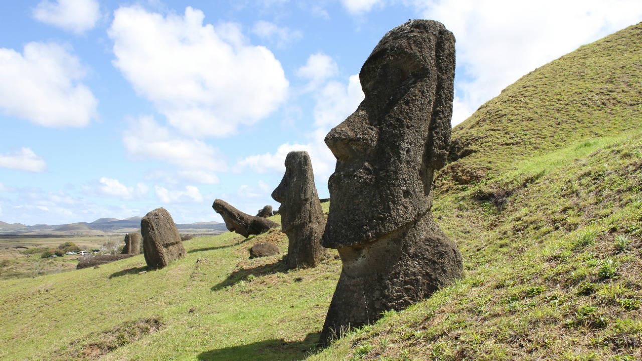
New 3D scans of Easter Island’s main quarry are turning a familiar mystery into a far more intricate story of labor, logistics, and landscape engineering. Instead of a single chaotic pit, the digital models reveal a carefully organized production zone where teams of moai carvers worked in parallel, leaving behind a hidden network of workspaces etched into the rock. For the first time, researchers can trace how these iconic statues moved from rough concept in the hillside to finished figure poised for its journey across the island.
By mapping thousands of overlapping chisel marks and half-finished figures, the scans show that the moai were not just isolated masterpieces but the output of a coordinated system that ran for centuries. I see a picture emerging of Rapa Nui communities who treated the quarry as both a sacred landscape and a highly efficient workshop, combining spiritual intent with practical know-how in ways that modern tools are only now beginning to decode.
From enigmatic quarry to mapped workshop
The new research starts by reframing the quarry at Rano Raraku not as a mysterious void where statues simply “appeared,” but as a structured workplace with its own internal geography. High resolution 3D models capture the contours of the crater walls, the slopes where unfinished moai lie embedded, and the terraces where carvers stood, revealing patterns that are almost impossible to see at ground level. When I look at those patterns as a whole, the quarry stops being a random scatter of stone and becomes a legible plan of how people organized their labor.
That shift in perspective is powered by a digital survey that stitched together more than 11,000 photographs into a single model of the site. The resulting High Resolution Modeling Reveals 30 Quarry Work Zones that cluster around natural ledges and access routes, suggesting that carvers deliberately divided the rock face into manageable sectors. Instead of imagining a few master sculptors roaming the crater, the data points to multiple teams working simultaneously, each with its own slice of the tuff and its own queue of statues in progress.
Thirty work zones and a hidden division of labor
Once the 3D model was in place, researchers could start to see how the quarry was partitioned into distinct production cells. The identification of 30 Quarry Work Zones is not just a cartographic detail, it is a clue to how Rapa Nui society organized expertise, apprenticeship, and authority. Each zone contains its own cluster of partially carved moai, tool marks, and access paths, which implies that specific groups of carvers may have claimed and maintained those spaces over long periods.
In practical terms, that division of labor would have allowed multiple statues to be carved at the same time, with teams specializing in particular stages of the process. Some zones appear to focus on roughing out the basic silhouette, while others show more refined work on facial features and backs, hinting at a workflow that moved statues from one area to another as they advanced. The high resolution 3D model makes those subtle differences visible, turning what once looked like a jumble of half-finished figures into a map of coordinated craftsmanship.
Tracing the carvers behind the stone
With the quarry now digitally captured in such detail, the next question is who, exactly, was doing the carving. The new models let archaeologists compare tool marks, statue styles, and spatial patterns in ways that were not possible when they had to rely on tape measures and sketchbooks. I see this as a shift from treating moai as anonymous icons to treating them as the work of identifiable communities, and perhaps even recurring teams of artisans whose “signatures” are encoded in the rock.
Recent analysis uses the 3D data to link specific carving styles to particular areas of the quarry, which in turn can be tied to nearby settlements and clan territories. One project, framed as a Model Unlocks Just Who Made Easter Island effort, treats the quarry as an “archeological Disneyland” in digital form, where researchers can virtually walk through the site and test hypotheses about which groups controlled which work zones. In that context, the moai become less like isolated monuments and more like the visible output of a social network, with each statue carrying the imprint of the carvers who shaped it and the communities that commissioned it.
How 3D modeling rewrites the moai origin story
For decades, the story of moai creation has leaned heavily on broad generalizations: statues were carved in the quarry, somehow moved across the island, and raised on ceremonial platforms. The new 3D scans complicate that narrative by showing just how varied the carving process was from one zone to another. Some statues appear to have been abandoned mid-carve when the rock fractured, while others were carefully undercut and prepared for removal, suggesting that carvers constantly adapted to the quirks of the stone and the demands of their patrons.
By aligning the digital quarry model with known moai on the coast, researchers can start to match specific statues to their birthplaces, effectively reconstructing individual life histories from bedrock to ahu. The High Resolution Modeling Reveals that production likely began in the 13th century and continued for generations, with different work zones waxing and waning in importance over time. That temporal layering turns the quarry into a kind of archive, where each carved ledge and abandoned statue records a moment in the island’s political and religious history.
From quarry to coast: the physics of “walking” moai
Understanding how the moai were carved is only half the story; the other half is how they left the quarry and reached their final destinations. Here, 3D modeling has also transformed the debate, particularly around the idea that the statues were moved upright in a rocking, “walking” motion. Earlier experiments struggled to reconcile that theory with the sheer size of the figures, but new tests grounded in digital reconstructions of the statues’ center of mass have made the scenario far more plausible.
In one study, a team used a detailed 3D model of a moai to design a full-scale replica and then tested how it moved when pulled with ropes from different angles. With just 18 people, they were able to transport the statue 100 meters in 40 m by rocking it from side to side, a marked improvement over previous attempts that required far larger crews. That result, described in an Oct experiment using 3D modeling, suggests that the statues’ distinctive forward-leaning design was not an accident but a functional feature that made them easier to “walk” along prepared paths.
A digital bridge between landscape and legend
The combination of quarry scans and transport experiments creates a bridge between the physical landscape and the oral traditions that say the moai “walked” to their platforms. When I put those strands together, the legends no longer read as metaphor alone; they look like compressed technical knowledge, passed down in story form long after the practical details were forgotten. The 3D models give that knowledge a new medium, turning myth back into method by showing how the statues’ shape and the island’s topography worked together.
Digital mapping also helps connect the quarry to the broader geography of Rapa Nui, including the coastal platforms and inland routes that define the island’s ritual landscape. By overlaying the quarry model with modern terrain data and the locations of known moai, researchers can trace likely transport corridors and staging areas, many of which align with features visible in satellite imagery and on the ground. Even tools like the Rano Raraku place viewer help illustrate how the crater sits in relation to the rest of the island, reinforcing the idea that the quarry was not an isolated pit but the starting node in a carefully choreographed network of movement.
Rano Raraku as a living, layered site
One of the most striking insights from the 3D scans is how densely layered the quarry is, both physically and historically. Statues overlap, with some carved partially over older figures, and work zones cut into earlier surfaces, creating a palimpsest of activity that spans centuries. In a traditional plan drawing, those layers blur together, but in the digital model they can be separated, rotated, and examined from any angle, revealing sequences of carving that hint at shifting priorities and changing ritual programs.
That layered view also underscores how dynamic the quarry remained even as moai production slowed and eventually stopped. Erosion, rockfalls, and later human activity all left their marks, which the 3D model captures alongside the original carving. When I look at that composite, I see Rano Raraku not as a frozen relic but as a living site that has been reinterpreted and reused over time, from its role as a sacred workshop in the 13th century to its status today as a focal point for tourism and heritage management.
What the carvers’ network reveals about Rapa Nui society
Mapping the carvers’ work zones does more than solve technical puzzles; it opens a window onto how Rapa Nui society distributed power and knowledge. If specific clans or lineages controlled particular sectors of the quarry, then access to stone and skilled labor would have been a key lever of influence. The spatial clustering of styles and tool marks suggests that some groups may have specialized in certain types of statues, perhaps tied to particular ancestors or deities, while others focused on volume or on serving distant communities.
Those patterns dovetail with the idea that the moai were part of a competitive display system, where different groups commissioned ever larger or more elaborate statues to assert their status. The Researchers at Binghamto who are building a digital quarry environment describe it as a way to test how those social dynamics might have played out in practice, by simulating how many statues a given work zone could produce and how quickly they could be moved. In that sense, the hidden network of carvers is also a hidden network of political relationships, etched into the rock in the form of production capacity and stylistic choices.
Why the digital quarry matters beyond Easter Island
The techniques used to map Rano Raraku have implications far beyond a single Pacific island. High resolution 3D modeling, built from thousands of overlapping images, is becoming a standard tool for documenting fragile archaeological sites, but the moai quarry shows how powerful it can be when combined with experimental archaeology and social interpretation. Instead of treating the model as a static record, researchers are using it as a sandbox to test how people moved, worked, and organized themselves in the past.
For me, that approach points toward a future in which many iconic sites, from Egyptian quarries to Andean road systems, are reinterpreted as networks of labor rather than isolated monuments. The Getting your audio player ready style of immersive storytelling that accompanies some of this work hints at how these digital models might eventually reach the public, turning complex data into experiences that let people virtually stand in a carver’s footsteps. In the case of Easter Island, that means the moai are no longer just faces on postcards; they are the visible tips of a deeply mapped, digitally reconstructed network of human skill and collaboration.
More from MorningOverview