SpaceX has crossed a symbolic milestone in the reusable-rocket era, flying a previously used Falcon 9 booster for the 500th time across its fleet while sending the Sentinel-6B ocean-mapping satellite into orbit. As I watched the mission unfold, it felt like a convergence of two big stories: the normalization of rocket reuse and the urgent need to track a warming planet’s rising seas with unprecedented precision.
Sentinel-6B is the latest in a decades-long line of ocean altimetry missions, and its ride to space on a veteran rocket underscores how routine commercial launches are now intertwined with climate science. The mission’s success means scientists will soon have another high-accuracy tool to monitor global sea level, coastal flooding risk, and the fingerprints of climate change across the world’s oceans.
Why the 500th reused rocket flight matters
When I say SpaceX has now flown a used rocket 500 times, I’m talking about the cumulative count of reflown Falcon 9 and Falcon Heavy boosters, not a single vehicle hitting that number. That aggregate milestone, reached with the Sentinel-6B launch, signals that reusability is no longer an experiment but the backbone of the company’s launch model, as highlighted in coverage of how SpaceX “utilizes its used rocket 500th time” to loft the satellite into orbit. Each reflown booster represents hardware that didn’t have to be rebuilt from scratch, driving down costs and enabling a cadence of launches that would have been unthinkable in the fully expendable era.
From my perspective, that 500-flight mark also changes the conversation about reliability. Early on, critics questioned whether reused rockets could match the safety record of fresh hardware; now, with hundreds of reflights behind it, SpaceX has built a statistical case that refurbishment and rigorous inspection can keep boosters flying safely. The Sentinel-6B mission, riding on a booster that had already proven itself on earlier flights, reinforces the idea that “used” in rocketry can mean “well-tested” rather than “second best,” a point echoed in reports that frame this launch as a milestone for both reusability and climate monitoring together.
How Sentinel-6B extends a 30-year sea-level record
Sentinel-6B is not a one-off experiment; it is designed as the follow-on partner to Sentinel-6 Michael Freilich, continuing a sea-level measurement record that stretches back to the TOPEX/Poseidon mission in the early 1990s. I see this continuity as the mission’s most important feature: by flying nearly identical instruments in the same kind of orbit, the new satellite can overlap with its predecessor and stitch together a seamless time series of global sea level, which scientists rely on to detect long-term trends rather than short-term noise. NASA and European partners describe Sentinel-6B as part of a U.S.-European collaboration to monitor Earth’s oceans with high-precision radar altimetry, extending a multi-decade climate data set that underpins projections of future sea-level rise worldwide.
That continuity is especially critical because sea level is not rising evenly; regional patterns driven by ocean currents, wind, and gravity mean some coastlines are seeing faster change than others. Sentinel-6B’s radar altimeter will measure the height of the ocean surface to within centimeters, allowing researchers to map subtle variations in sea level and ocean topography that reveal how heat and salt are moving through the seas. Reporting on the mission emphasizes that this satellite will help track global sea-level changes and refine models that predict coastal flooding risk, building on the work of earlier altimetry missions and ensuring that the record does not suffer a gap as older spacecraft age in orbit.
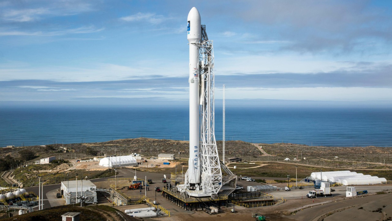
The launch profile: from California coast to climate orbit
From a launch-watcher’s standpoint, Sentinel-6B’s ride to space followed a now-familiar pattern: a Falcon 9 lifting off from the California coast, arcing southward over the Pacific to reach a high-inclination orbit ideal for global coverage. The mission profile, as described in detailed launch reports, involved a first-stage ascent, stage separation, and a second-stage burn to place the satellite into its targeted orbit, followed by deployment once systems were confirmed nominal over Earth. For me, the striking part is how routine this choreography has become, even when the payload is a flagship climate satellite.
What viewers saw on the live broadcast was a polished sequence of events: the crack of ignition, the booster’s climb through max-Q, and the smooth handoff to the upper stage as the first stage peeled away to head back toward a landing zone. Video of the mission shows the booster’s controlled descent and landing burn, underscoring how recovery has become an integral part of the launch narrative rather than a novelty tacked on. That choreography—launch, orbit insertion, and booster return—embodies the dual goals of the mission: deliver a critical climate observatory while preserving the hardware that made it possible.
Inside the satellite: radar altimetry and ocean topography
At the heart of Sentinel-6B is a radar altimeter that sends pulses toward the ocean surface and measures how long they take to bounce back, turning timing data into precise height measurements. I think of it as a space-based tape measure, constantly scanning the seas to map sea-surface height, wave conditions, and large-scale features like ocean eddies and currents. Technical briefings on the mission explain that the satellite’s instruments are tuned to detect changes in global mean sea level on the order of millimeters per year, a level of precision that allows scientists to separate long-term climate signals from short-term variability driven by storms or seasonal cycles in the data.
Those measurements feed directly into models that forecast everything from hurricane intensity to El Niño events. By mapping ocean topography—the subtle hills and valleys on the sea surface created by temperature and salinity differences—Sentinel-6B helps researchers understand how heat is stored and transported in the oceans, which in turn shapes weather patterns on land. Coverage of the mission notes that the satellite’s data will be used to refine forecasts and improve our understanding of how a warming climate is reshaping the oceans, giving coastal planners and emergency managers better tools to anticipate future risks from the sea.
A transatlantic partnership focused on climate risk
One of the aspects I find most compelling about Sentinel-6B is how it embodies international cooperation around climate science. The mission is a joint effort involving U.S. and European agencies, including NASA and European partners, who have spent decades building and flying ocean altimetry satellites together. Official mission descriptions emphasize that this collaboration is designed to ensure a continuous, high-quality record of sea-level data that is freely available to researchers and policymakers around the world, reinforcing the idea that climate monitoring is a shared responsibility rather than a national project alone.
That partnership extends beyond the spacecraft itself to the ground segment and data processing pipelines that will turn raw radar returns into usable information. Analysts have pointed out that the mission’s success depends on a network of receiving stations, calibration efforts, and climate models maintained on both sides of the Atlantic, all of which must be carefully synchronized. Live coverage of the launch highlighted representatives from multiple agencies celebrating the liftoff, underscoring how Sentinel-6B’s data will feed into global assessments of sea-level rise and inform decisions from coastal zoning to infrastructure investments worldwide.
What the mission means for coastal communities
For people living along the world’s coasts, Sentinel-6B’s measurements are not abstract—they translate into better information about flooding, erosion, and storm surge. By extending the sea-level record, the satellite helps clarify how quickly oceans are rising and how that rise varies from place to place, which is crucial for cities deciding whether to build seawalls, elevate roads, or retreat from vulnerable areas. Reporting on the mission stresses that the satellite’s data will be used to monitor sea-level changes that affect coastal communities, giving planners a more reliable foundation for long-term decisions about housing, transportation, and critical infrastructure near the shore.
In my view, the value of this mission will be measured not just in scientific papers but in how its data filters into everyday tools. When weather apps warn of king tides in Miami or storm surge in New Orleans, they rely on models that are tuned using decades of satellite altimetry. Sentinel-6B’s contribution will be to keep those models anchored to reality as climate change accelerates, reducing the uncertainty that can paralyze local governments. Analysts following the launch have emphasized that the satellite’s role in tracking global sea-level rise is directly linked to protecting lives and property, making it a climate mission with very tangible stakes for communities.
Reusability, livestreams, and the new normal in spaceflight
Watching the Sentinel-6B launch, I was struck by how normalized the spectacle has become: millions of viewers tuning into a livestream, cheering a booster landing, and then moving on with their day as if sending a climate observatory to orbit on a reused rocket were just another Tuesday. High-definition broadcasts of the mission show crisp views from onboard cameras, telemetry overlays, and real-time commentary that walk audiences through each phase of flight from liftoff to landing. That level of transparency has helped demystify spaceflight and build public familiarity with concepts like booster reuse and fairing recovery.
At the same time, the 500th reused flight milestone suggests that what once seemed radical—landing and re-flying orbital-class boosters—is now baked into the business model of getting satellites like Sentinel-6B into space. Analysts covering the mission have framed it as part of a broader shift in which commercial launch providers supply the muscle for government-led science missions, blending private-sector efficiency with public-sector research goals on climate. As I see it, that hybrid model is likely to define the next decade of space-based Earth observation, with reusable rockets making it cheaper and faster to refresh the fleet of satellites watching our changing planet.
More from MorningOverview