Earth researchers have spent generations decoding the Grand Canyon, turning its cliffs and chasms into one of the clearest records of our planet’s deep past. These nine Grand Canyon facts, grounded in current geological work and broader Earth science, show how the canyon’s rocks, fossils, and hidden structures keep reshaping what I understand about Earth’s history.
1. The Grand Canyon’s rocks record nearly 2 billion years of Earth history
The Grand Canyon’s most striking fact is the sheer span of time preserved in its walls, with rock units that extend back roughly 1.8 to 2 billion years. At the canyon’s base, ancient crystalline rocks known as the Vishnu Basement Rocks represent some of the oldest exposed material in North America, while younger layers near the rim capture much later chapters in Earth’s story. When I look at that vertical stack, I am effectively reading a rock archive that stretches from early continental crust to relatively recent desert environments, all in one continuous cliff face.
This immense time range is not a rough guess but a conclusion drawn from radiometric dating, fossil assemblages, and regional correlations that match Grand Canyon layers to formations across the American Southwest. For geologists, the canyon functions as a reference library, where each formation has a known age range and characteristic fossils. That long record is crucial for understanding how continents assembled, how ancient seas advanced and retreated, and how life diversified over hundreds of millions of years, giving researchers a precise framework for testing new ideas about Earth’s evolution.
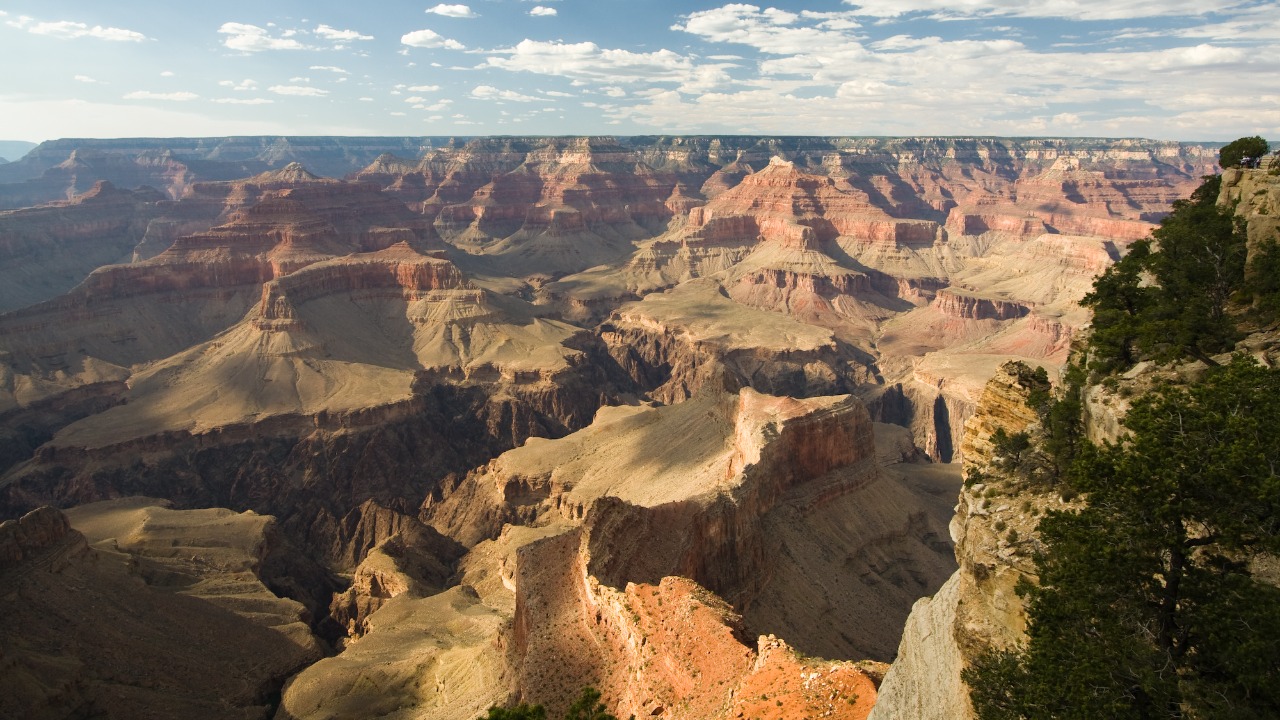
2. Layered “stripes” in the canyon walls reveal vanished oceans and deserts
The colorful stripes that tourists photograph are not just scenic, they are distinct sedimentary formations that record radically different ancient environments. Some of the canyon’s limestones formed on the floors of shallow tropical seas, while cross-bedded sandstones preserve the sweeping curves of long-vanished desert dunes. When I trace those layers with my eyes, I am following shorelines that migrated, rivers that shifted course, and dunes that marched across landscapes that no longer exist. Each band of rock is a snapshot of climate, sea level, and geography at a specific moment in deep time.
Because these layers can be matched to similar rocks far beyond Arizona, the Grand Canyon helps researchers reconstruct the broader geography of ancient North America. The same marine limestones that appear in the canyon, for example, can be traced into Utah and Nevada, confirming that a wide inland sea once covered much of the region. Those correlations let scientists map where coastlines lay, how thick sediment piles became, and how tectonic forces later lifted and tilted them. For climate modelers and stratigraphers, the canyon’s stripes are a benchmark for testing how global sea-level changes and regional uplift interacted over hundreds of millions of years.
3. New work in ancient canyon layers is forcing textbook updates
Recent research in some of the canyon’s oldest strata has uncovered structural and chronological details that are prompting scientists to revise long-standing models of regional geology. Investigations into the ancient layers have revealed previously unrecognized faults, folding patterns, and contact relationships that change how geologists interpret the timing of uplift and erosion. One study of the canyon’s deep rock record reported that subtle features in the ancient layers require a fresh look at when certain tectonic events occurred, a finding highlighted in coverage of new secrets in the ancient layers.
Those discoveries matter because they refine the sequence of events that shaped not only the Grand Canyon but also the broader Colorado Plateau. If a fault turns out to be younger than previously thought, or if a contact between two formations formed under different conditions than assumed, then models of river incision, plateau uplift, and regional stress fields must be updated. For land managers, educators, and researchers, these revisions ripple outward, influencing hazard assessments, resource studies, and how geology is taught in classrooms. The canyon’s rocks are not just static scenery, they are active research sites that continue to overturn earlier assumptions and sharpen the timeline of Earth’s tectonic history.
4. The canyon’s depth reflects a powerful partnership between uplift and river erosion
The Grand Canyon’s depth, in some places more than 1,800 meters from rim to river, is the result of a long partnership between rising land and a persistent river. As the Colorado Plateau slowly uplifted, the Colorado River and its tributaries cut downward, carving through layer after layer of rock. Without uplift, the river would have meandered across a broad plain instead of slicing a deep gorge, and without a sustained river system, the uplifted plateau would not display such dramatic relief. The canyon’s vertical scale is therefore a direct measure of how tectonics and surface processes have interacted over millions of years.
Researchers use the canyon as a natural laboratory to quantify erosion rates and test how rivers respond to changes in elevation and climate. By dating terraces, volcanic flows, and carved surfaces, they can estimate how quickly the river deepened its channel and how incision rates varied over time. Those numbers feed into models that help predict how modern rivers might react to future uplift, climate shifts, or human interventions such as dams. For communities downstream and planners managing water and infrastructure, understanding that deep-time interplay between uplift and erosion provides context for present-day flood risks, sediment transport, and landscape stability.
5. Fossils in canyon rocks chart major steps in life’s evolution
Although the Grand Canyon is not famous for dinosaur skeletons, its rock layers contain a rich fossil record that documents key transitions in ancient life. Marine limestones preserve invertebrates such as brachiopods, trilobites, and crinoids, while other units hold traces of early land plants and trackways left by animals moving across coastal flats. When I examine those fossils in context, I see a progression from simple marine ecosystems to more complex communities that include organisms venturing onto land, all captured in a vertical sequence of rock.
These fossils are crucial for correlating canyon formations with rocks elsewhere and for calibrating the timing of evolutionary milestones. Because many fossil groups evolved rapidly and have distinctive shapes, paleontologists can use them as index fossils to assign relative ages to the layers that contain them. That biostratigraphic framework, combined with radiometric dates, anchors the canyon’s rock record within the global timeline of life’s history. For evolutionary biologists and educators, the Grand Canyon offers a tangible, walkable cross-section of how life diversified through changing seas, shorelines, and climates, reinforcing the broader narrative of deep evolutionary time that underpins modern biology and medicine.
6. Genetic research on humans contrasts sharply with the canyon’s deep-time record
Some researchers working in genetics have argued for a relatively recent origin of humans, interpreting patterns in DNA as evidence for a young human population history. One example is a study presented in a piece on genetics supporting a young Earth, which claims that mutation rates and genetic diversity are consistent with a timescale of only thousands of years. That argument focuses on human ancestry and population models, using genetic data to propose a compressed chronology for human history.
When I compare that kind of young-Earth interpretation with the Grand Canyon’s rock record, the contrast is stark. The canyon’s stratigraphy, radiometric ages, and fossil assemblages collectively indicate that its rocks span hundreds of millions to billions of years, far exceeding any timescale measured in thousands of years. In mainstream Earth science, the canyon’s deep-time evidence is considered robust and is supported by multiple independent dating methods and global correlations. The genetic claims for a young Earth therefore sit outside the scientific consensus and are not used by geologists to interpret the canyon. For educators, this divergence underscores the importance of distinguishing between views grounded in converging geological evidence and those that reinterpret data to fit a much shorter chronology.
7. The canyon helps calibrate radiometric dating techniques
The Grand Canyon’s well-exposed layers and known sequence make it a key site for testing and refining radiometric dating methods. Geologists can sample volcanic ash beds, igneous intrusions, and mineral grains within the canyon’s formations, then compare the resulting ages to the relative order of layers established by stratigraphy and fossils. When radiometric dates align with the expected sequence, they strengthen confidence in both the dating techniques and the geological timeline. If discrepancies appear, they prompt closer scrutiny of sample selection, alteration, or analytical methods, improving the precision of age estimates.
Because the canyon’s rocks span such a wide range of ages, they allow scientists to apply different isotopic systems, including uranium-lead, potassium-argon, and argon-argon dating, across multiple time windows. Cross-checking these methods against each other within the same region helps identify systematic biases and refine decay constants and calibration standards. Those improvements extend far beyond Arizona, influencing how researchers date volcanic eruptions, mountain-building events, and the timing of mass extinctions worldwide. For fields like planetary science and climate research, which rely on accurate timelines, the Grand Canyon’s role as a calibration site reinforces its status as a cornerstone of modern geochronology.
8. Ongoing canyon studies reshape hazard and resource planning
Modern research in and around the Grand Canyon is not limited to reconstructing ancient environments, it also informs present-day hazard assessment and resource management. Detailed mapping of faults, landslide deposits, and rockfall zones helps identify areas where cliffs are unstable or where seismic activity could trigger slope failures. Hydrologists studying how water moves through the canyon’s fractured rocks and aquifers provide critical data for understanding spring flows, groundwater recharge, and the potential impacts of drought. Those findings guide decisions about trail placement, infrastructure, and emergency planning for the millions of visitors who enter the region each year.
At the same time, studies of sediment transport and river dynamics within the canyon influence how managers operate upstream dams and reservoirs. By tracking how sandbars, beaches, and habitats respond to changes in flow, researchers can recommend release schedules that better balance power generation, recreation, and ecosystem health. The canyon’s role as a natural laboratory for these processes means that insights gained there can be applied to other river systems facing similar pressures from climate change and human use. For policymakers and local communities, the science emerging from the Grand Canyon directly shapes strategies for safety, conservation, and sustainable tourism.
9. The Grand Canyon remains a benchmark for testing new Earth science ideas
Across geology, paleontology, hydrology, and tectonics, the Grand Canyon functions as a benchmark against which new hypotheses are tested. When researchers propose a model for how plateaus uplift, how rivers respond to base-level changes, or how sedimentary basins fill and empty, they often ask whether that model can reproduce the patterns seen in the canyon’s rocks and landforms. The clarity of the canyon’s exposures, combined with decades of detailed mapping and dating, makes it a demanding but invaluable proving ground. If a theory cannot account for the canyon’s sequence of layers, incision history, and structural features, it is unlikely to hold up elsewhere.
That benchmark role has broader implications for how Earth science progresses. As new tools such as high-resolution satellite imagery, thermochronology, and numerical landscape models become available, they are quickly applied to the Grand Canyon to see what additional detail they can reveal. Each new dataset either reinforces existing interpretations or exposes gaps that require fresh thinking, ensuring that the canyon remains central to debates about Earth’s long-term behavior. For students, researchers, and the public, this ongoing cycle of testing and refinement at one of the world’s most iconic landscapes illustrates how scientific understanding of our planet is built, challenged, and improved over time.
More from MorningOverview