The next great American tsunami is not a Hollywood fantasy but a scenario that coastal planners, geologists and emergency managers now treat as a near inevitability. Their fear is rooted in hard numbers, from the size of the fault lurking offshore to the height of waves that could erase entire neighborhoods in minutes. What keeps them up at night is not only the scale of the water, but how little time millions of people would have to get out of its way.
At the center of those worries is the Cascadia region, where a single offshore rupture could unleash a wall of water across the Pacific Northwest and beyond. I see the growing body of research, drills and public warnings converging on the same blunt conclusion: the country is still not ready for the day the ocean suddenly rushes inland.
The sleeping giant off the Pacific Northwest
Scientists focus their concern on The Cascadia Subduction Zone, a 700-mile fault that runs from northern California up to British Columbia and is about 70 to 100 m offshore. Along this boundary, one tectonic plate is slowly diving beneath another, locking up until the strain is released in a single violent slip that can produce a magnitude 9 earthquake and a basin-wide tsunami. State emergency officials describe this offshore system as the dominant seismic threat to the region, with the potential to shake cities from the California North Coast to Vancouver Island and send destructive waves toward every low-lying harbor and beach community in between, a risk detailed in state guidance.
Researchers emphasize that the question is not whether this fault will rupture again, but when. Regional analyses warn that a major earthquake along the Cascadia fault off the Pacific Northwest coast is a matter of when, not if, and that such an event could generate a huge tsunami capable of flooding coastal towns and river estuaries far inland, as highlighted in recent regional reporting. County-level planning documents go further, noting that when it eventually ruptures, which scientists predict could happen in the next 50 years, it will devastate communities and infrastructure and threaten hundreds of thousands of people in Oregon and Washington, a warning spelled out in the Key Takeaways for local governments.
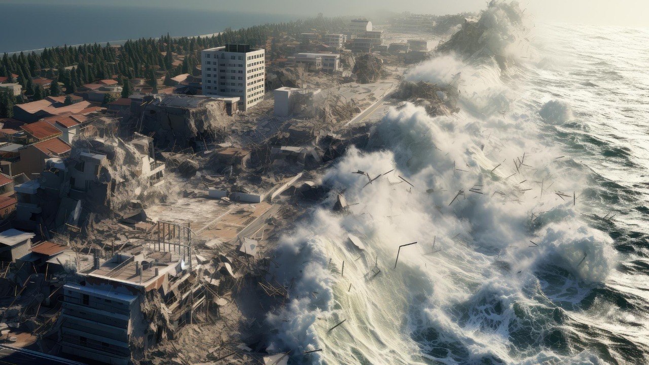
What the next Cascadia tsunami would actually do
To understand why experts sound so alarmed, it helps to picture the sequence they expect when Cascadia finally snaps. As the shaking begins, coastal residents will feel the ground heave and roll, but everyone on the coast will know that the worst is yet to come and that they will need to evacuate as soon as the land stops shaking to escape to higher ground, a scenario laid out in detailed educational modeling. While the shaking is occurring the land is dropping, and, depending on tidal conditions, low-lying areas may experience rapid flooding even before the largest waves arrive, a process described in recent interviews that begin with the phrase While the shaking continues.
Federal scientists now warn that the threat is not limited to the initial surge of water. Research on The Threat of Coastal Flooding from Cascadia Earthquake Driven Land Subsidence finds that coastal floodplains would expand, and areas that are currently dry could become inundated within minutes, with the sinking of the land surface making long term flooding more severe in future storms and high tides, a pattern documented in new subsidence research. One Virginia Tech study cited in that work and in later coverage warns that Cascadia flooding and “subsidence” could leave parts of the coast under six feet of water in minutes, with Geologists at the Virginia Tech College of Science stressing that this combination of sinking land and incoming waves magnifies the danger, as summarized in a recent Cascadia analysis.
From 100-foot walls of water to 1,000-foot outliers
When people talk about a “mega-tsunami,” they are usually thinking of waves on a scale that dwarfs even the worst historical disasters. Federal estimates now warn that an offshore megaquake could cause a tsunami of roughly 100 ft that would slam into parts of the West Coast, a scenario that has been shared widely in a Dec warning about a Seismic Warning for America and the Cascadia Threat Looms Scientists who study the Cascadia Sub hazard. Separate work on extreme events notes that a 1,000-foot mega-tsunami could erase parts of the U.S., and that scientists say it has happened before in Earth’s geologic past, with inland communities also impacted and several states already working on preparedness for such low probability but high consequence scenarios, as described in a Jun feature on 1,000-foot waves.
Researchers caution that the Cascadia event most likely to occur in our lifetimes would produce waves closer to the 100 ft range than the 1,000-foot outliers, but they argue that even this “ordinary” megaquake would be catastrophic without better warning and infrastructure. A Virginia Tech study warns that a Cascadia tsunami could raise water levels by as much as 6.5 feet in some harbors on top of existing tides, and that such surges would interact with local topography in complex ways that could funnel water into specific neighborhoods, a concern highlighted by Aug coverage of Researchers calling for upgrades. Earlier this year, another analysis of mega-tsunamis triggered by earthquakes stressed that, while a 1,000-foot wall of water is unlikely on the modern U.S. coastline, the physics that created such waves in the past still apply, and that coastal planning must account for compound risks from shaking, landslides and seafloor collapse, a point reinforced in a Jun analysis that begins with the word But and traces how strain accumulates over centuries.
Communities in the crosshairs
For coastal residents, these projections translate into very specific maps of who is most at risk. In Oregon, state-backed modeling of expected impacts shows how entire stretches of the coast could be cut off when bridges fail, ports are damaged and tsunami waves overtop dunes and seawalls, with the site Surviving Cascadia using Oregon specific estimates to help people visualize which neighborhoods will be inside the inundation zone, as laid out in its Oregon impact scenarios. Farther north, provincial officials are asking a similar question in British Columb coastal towns, with one recent assessment bluntly asking whether a major earthquake is coming and is British Columbia ready, and noting that, According to the British Columb emergency management guidance, even communities that sit on bluffs above the water depend on roads, ports and utilities that run through low-lying zones, a concern captured in a Jan report.
Smaller cities are discovering that their exposure is greater than they once believed. PORT ANGELES, Wash officials, for example, now warn that Port Angeles faces significant tsunami danger from a Cascadia subduction zone earthquake that could send waves racing into its harbor, with new modeling showing that damage would not be limited to maritime infrastructure but could reach residential and commercial districts as well, findings summarized in a Port Angeles risk study. Along the California North Coast, planners are also being told to prepare for a magnitude 9 earthquake on The Cascadia subduction zone offshore of California’s North Coast, with scenarios in which buildings are toppled and coastal towns isolated by landslides and damaged highways, a chain of events described in a detailed Oct briefing on how Cascadia and the San Andreas might interact.
Why scientists say the clock is ticking
What truly unnerves experts is how little time coastal communities will have to react when the next big rupture begins. In a recent real world test, an 8.8 m earthquake that struck Russia’s far east shook nerves but spared the Pacific from actual disaster, with the tsunami it generated taking hours to cross the ocean and giving emergency managers time to issue alerts and clear beaches, a sequence recounted in a Jul video on that event. By contrast, a Cascadia earthquake would occur just tens of miles offshore, leaving some beaches only minutes between the end of the shaking and the arrival of the first wave, a gap that scientists say is too short to rely on sirens or smartphone alerts alone.
Emergency agencies are trying to close that gap, but they admit that progress is uneven. The State of Oregon Department of Emergency Management has launched a series of Be Prepared for Earthquakes and Tsunamis workshops on the Oregon Coast Join Oregon communities, urging residents to build “2 Weeks Ready” kits and memorize evacuation routes, as described in a preparedness campaign and in separate outreach that invites people to Be Prepared for Earthquakes and Tsunamis on the Oregon Coast Join Oregon ( State of Oregon ) Department of Emergency Management sessions in coastal communities this spring, as outlined in a workshop notice. Nationally, scientists from Virginia Tech and other institutions are warning that massive flooding and tsunamis could affect thousands of people and that new simulations of how earthquakes deform the seafloor will have a direct impact on future tsunami forecasts, a point made in a Virginia Tech led study.
At the same time, recent events have shown both the strengths and limits of current warning systems. When a magnitude 8.8 earthquake near the Kamchatka Peninsula, Russia created an ocean crossing tsunami that reached North America, the first waves took hours to arrive, and Ej Ri PAC NW neighbors were urged to visit Washington Emergency Management Division and Oregon Department of Emergency Managem sites to understand how alerts are issued and why the first wave is not always the largest, guidance shared in a tsunami recap. For Cascadia, scientists warn that only a combination of education, vertical evacuation structures and hardened infrastructure will keep that kind of alert system from becoming a record of what went wrong after the next great American tsunami has already come and gone.
That is why, when I talk to researchers about Cascadia, the mood is less about abstract dread and more about a race against time. They know the fault will rupture again, they know roughly how high the water can rise, and they know which towns sit squarely in the path of the waves. What they do not yet know is whether the country will treat those warnings as a blueprint for survival or as a postscript to a disaster that scientists have been describing in detail for years.
More from Morning Overview