Archaeologists in Ireland have identified what they describe as the largest clustered prehistoric village ever found in Britain and Ireland, a hilltop community whose scale and planning overturn long‑held assumptions about how people on the island lived more than two thousand years ago. The discovery reveals a dense, defended settlement with multiple rings of ramparts and dozens of houses, suggesting a level of social organization and regional influence that rivals early towns. It is a find that forces a fresh look at Ireland’s prehistoric past, from everyday domestic life to the balance of power across the wider Atlantic world.
A hilltop giant hiding in plain sight
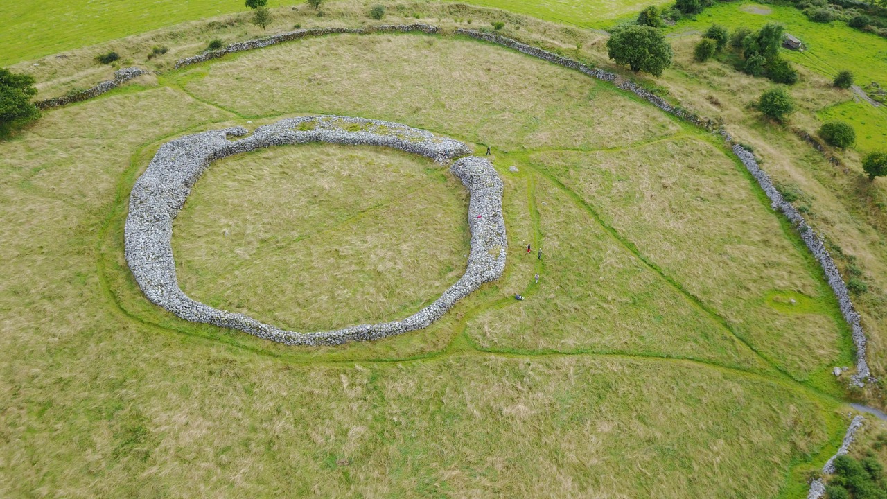
The newly documented settlement sits on a prominent hilltop, enclosed by massive earthworks that would have dominated the surrounding landscape and signalled power to anyone approaching. Rather than a single ringed fort or isolated farmstead, archaeologists describe a sprawling, nucleated community, with houses clustered between multiple defensive ramparts and a clear sense of internal planning. From the air, the outlines of banks, ditches and platforms resolve into a coherent prehistoric neighborhood, not just a fortified refuge.
Researchers link this site to a broader complex of at least 13 large hilltop enclosures spread across the same mountain range, suggesting that the village was part of a network of high‑status centers that structured life in the region. One of these enclosures, identified as a recently discovered large hilltop settlement, has already been cited as significant enough to challenge the long‑standing theory that Vikings were responsible for building the first Irish towns, because it shows dense occupation and organized space centuries earlier within the Atlantic Archipelago, a pattern echoed at the new village site and supported by the wider cluster of large hilltop enclosures.
From hillfort to village: what makes it “largest”
Archaeologists are not simply counting ramparts when they call this Ireland’s largest prehistoric village, they are looking at how many people could have lived here at once and how tightly they were packed together. The settlement is described as a nucleated or agglomerated community, meaning houses were grouped closely rather than scattered across the countryside, and the enclosed area is extensive enough to accommodate a substantial population. Within the inner defenses, traces of roundhouses, yards and working spaces suggest a continuous belt of occupation rather than a few elite dwellings.
Specialists date the occupation firmly to the Late Bronze Age and Early Iron Age, between 1193 BC and 410 BC, a span that covers several centuries of social change and technological innovation in Ireland. One researcher has emphasized that the settlement clearly dates to this Late Bronze Age and Early Iron Age window and represents a nucleated or agglomerated community that was already thriving by around 750 BC, a chronological anchor that helps distinguish it from later medieval ringforts and supports the claim that it is the largest clustered village known in all of prehistoric Britain and Ireland, as outlined in the detailed description of the Late Bronze Age and Early Iron Age site.
How scientists pieced the settlement together
The scale and complexity of the village only became clear once archaeologists combined aerial survey, remote sensing and targeted excavation, a toolkit that has transformed how prehistoric landscapes are mapped. From above, subtle differences in vegetation and soil moisture picked out the lines of buried ditches and banks, while geophysical instruments traced the circular footprints of houses and internal divisions hidden beneath the turf. These non‑invasive methods allowed researchers to see the entire layout before cutting any trenches, revealing a planned interior with zones for housing, storage and perhaps communal activity.
Once the pattern was clear, teams opened a series of small but carefully placed test excavations to ground‑truth what the remote data suggested. Four such trenches were dug to understand how the site was occupied and how its enclosing elements developed over time, with each test ranging from six to more than twenty meters in length and targeting key features like rampart junctions and house platforms. The results, which included structural remains and datable material, have been described as hugely exciting prehistoric artifacts that help refine the chronology of the enclosing elements and confirm that the visible earthworks belong to a single, coherent prehistoric phase rather than a palimpsest of later reuse, as reported in the account of the Four test excavations.
Domestic life inside a prehistoric “megasettlement”
What emerges from the combined evidence is a picture of dense domestic life, with families living side by side in a defended hilltop neighborhood that functioned as a true megasettlement. Roundhouses appear to have been arranged in clusters, perhaps reflecting kin groups or craft specializations, and the spaces between them were likely filled with small yards, animal pens and working areas. The presence of multiple ramparts enclosing this built‑up interior suggests that the community invested heavily in protecting not just people but also stored food, livestock and valuable materials, a sign of both prosperity and perceived threat.
Comparable work in County Wicklow has already shown how such large, enclosed communities mark a leap in settlement complexity, with one newly uncovered Bronze Age megasettlement there described as challenging long‑held beliefs about Ireland’s first towns. Through aerial survey and detailed mapping, that Wicklow site revealed a dense concentration of houses and activity areas that blur the line between fortified farm and proto‑urban center, a pattern that closely parallels what is now being documented at the largest prehistoric village and underscores how these hilltop communities represent a step change in how people organized domestic life, as highlighted in the analysis of the Newly Uncovered Bronze Age Megasettlement.
Rewriting Ireland’s early urban story
For decades, schoolbook narratives have credited Viking raiders and traders with introducing urban life to Ireland, pointing to coastal longphorts and later towns as the first true centers of population and commerce. The hilltop village now emerging from the soil complicates that story by showing that large, planned and densely populated settlements existed in the Irish interior long before Viking ships appeared on the horizon. Instead of isolated farmsteads and small ringforts, the Late Bronze Age and Early Iron Age landscape now includes what looks very much like an inland town in all but name.
Archaeologists working on related hilltop sites have already argued that such discoveries may challenge the theory that Vikings built the first Irish towns, because the newly documented enclosures show complex internal layouts, evidence of craft production and signs of regional influence that predate Scandinavian activity by centuries. One recently identified large hilltop settlement has been singled out as a key example of this earlier urban‑like development within the Atlantic Archipelago, and the scale of the largest prehistoric village strengthens the case that Ireland’s trajectory toward town life began in the Bronze Age, as suggested by the growing body of evidence around the theory Vikings built first Irish towns.
A settlement of regional, not just local, power
The size and fortification of the village point to a community that mattered far beyond its immediate hilltop, likely acting as a focal point for trade, ritual and political authority across a wide hinterland. Multiple ramparts, some of them monumental in scale, would have required coordinated labor to build and maintain, implying leadership structures capable of mobilizing and directing large work parties. Inside the defenses, the density of houses and activity areas suggests a population that could have hosted markets, seasonal gatherings or assemblies that drew people from smaller surrounding sites.
Researchers studying Ireland’s largest prehistoric hillfort settlement have emphasized that what makes such sites unique is not only their size but also their role as central places that emerged hundreds of years earlier than traditionally recognized in the island’s social development. In a recent study, scientists argued that these hillforts and hilltop villages represent a form of early centralization, with evidence that they served as hubs for exchange and decision‑making long before later historical polities took shape, a conclusion that aligns with the interpretation of the new village as a regional power center and is supported by the detailed discussion of Scientists who have uncovered evidence of Ireland’s largest prehistoric hillfort settlement.
Part of a wider prehistoric landscape
The hilltop village does not stand alone, it is part of a broader constellation of prehistoric sites that together map out a surprisingly interconnected Ireland. Across the island, archaeologists have documented other large enclosures, ceremonial complexes and defended settlements that appear to share architectural ideas and perhaps social institutions. The newly recognized village fits into this pattern as one of the most extreme examples of nucleated living, but its ramparts and internal layout echo features seen at other major sites, suggesting that communities were learning from and competing with one another.
One recent synthesis of discoveries across an Irish nature preserve described a vast new complex of prehistoric settlements, including multiple hillforts and associated features, and argued that these finds together represent the largest prehistoric settlement system yet documented in Britain and Ireland. That work highlighted how clusters of enclosures, trackways and domestic sites form a coherent landscape of occupation rather than isolated dots on a map, a perspective that helps frame the new hilltop village as a key node within a much larger network of prehistoric Irish settlements, as outlined in the discussion of the Largest Prehistoric Settlement in Britain and Ireland Discovered.
Why the Wicklow mountains keep yielding surprises
The concentration of major hilltop sites in the Wicklow region is no accident, the mountains offer natural defenses, commanding views and access routes that link the Irish interior to the coast. Archaeologists have increasingly turned their attention to this landscape, using drones, lidar and systematic fieldwalking to pick out previously overlooked earthworks and settlement traces hidden among forestry and heather. The result has been a cascade of discoveries that recast Wicklow not as a marginal upland but as a prehistoric heartland where some of the island’s most ambitious communities chose to build.
Digital mapping tools have been particularly important in this terrain, where traditional ground survey can miss subtle features spread across ridges and plateaus. One project, which focused on a vast prehistoric hilltop settlement discovered in Ireland, used high‑resolution imagery to trace the full extent of ramparts and internal structures that had been partially obscured by later land use, revealing a complex that rivals the newly identified village in both size and sophistication. That work, which credits Antiquity for publishing the core analysis and includes an image credit for the site plan, underscores how modern technology is transforming our understanding of upland archaeology, as seen in the report on the Vast Prehistoric Hilltop Settlement Discovered in Ireland.
From academic paper to public landmark
For now, much of what is known about the largest prehistoric village comes from specialist studies and technical reports, but the site is already beginning to filter into public consciousness. Heritage bodies and local authorities face the challenge of balancing protection with access, deciding how much of the hilltop to open to visitors and how to interpret earthworks that, to an untrained eye, can look like little more than grassy banks. There is also the question of how to integrate this new narrative of early complexity into museums, school curricula and tourism campaigns that have long leaned on later medieval and Viking stories.
Some of the first public‑facing descriptions have come through digital platforms that showcase the site’s location and basic features, including map‑based entries that situate the hilltop within its wider landscape and offer images of the surviving earthworks. One such entry highlights the coordinates and topography of the enclosure and provides a visual sense of the ramparts and interior, giving non‑specialists a way to appreciate the scale of the discovery even before formal visitor infrastructure is in place, as illustrated by the online presentation of the hilltop location that anchors the new research.
What comes next for Ireland’s prehistoric past
The identification of Ireland’s largest prehistoric village is unlikely to be the final word on the island’s early settlement story, if anything, it sets the stage for a new wave of discoveries and debates. Archaeologists are already planning more extensive excavations to sample different parts of the enclosure, from ramparts to house interiors, in order to refine the chronology and understand how the community changed over time. Environmental specialists will analyze pollen, seeds and animal bones to reconstruct diet and land use, while specialists in metalwork and ceramics will look for evidence of craft production that might explain the village’s regional pull.
At the same time, the site is prompting scholars to revisit other large enclosures that were previously written off as purely defensive or ceremonial, asking whether some of them might also conceal dense domestic quarters that would qualify as prehistoric villages or even early towns. Digital tools make it easier to test these ideas quickly, with updated satellite imagery and lidar scans already being used to re‑examine the same hilltop coordinates and surrounding terrain that first brought the new village to light, a process reflected in the evolving online records for the mapped enclosure and its neighboring sites.
A more complex Ireland than anyone expected
Taken together, the evidence from this hilltop village and its sister sites paints a picture of prehistoric Ireland that is far more complex, connected and hierarchical than older models allowed. Instead of scattered homesteads loosely tied by kinship and seasonal gatherings, we see large, defended communities that invested in monumental earthworks, coordinated labor and long‑distance exchange. These were societies capable of planning at scale, managing surplus and projecting power across landscapes, qualities that align them with early centers elsewhere in Europe rather than placing them on the periphery.
Archaeologists who first described the largest prehistoric village in Britain and Ireland have emphasized that the site’s clustered houses, double ramparts and extensive enclosed area make it a benchmark for understanding how communities in this part of the world experimented with dense living. Their work, which identifies what may be the most substantial agglomerated settlement of its kind and notes that the majority of domestic structures lie between two major ramparts, provides a template for recognizing similar patterns at other sites and underscores how much there is still to learn about Ireland’s deep past, as detailed in the account titled Archaeologists Uncover the Largest Prehistoric Village in Britain and Ireland.
More from MorningOverview