When a mountainside collapsed into a remote Greenland fjord in 2023, it did far more than send a wall of water racing toward the cliffs. The impact launched a 650-foot wave that sloshed back and forth so powerfully it made the entire planet vibrate every 92 seconds, a subtle global hum that persisted for more than a week. What began as a local disaster in icy Dickson Fjord became a planetary-scale experiment in how climate‑stressed landscapes can jolt Earth’s crust and oceans alike.
I see this event as a rare, almost cinematic glimpse of the climate crisis operating in real time: warming-driven instability in the Arctic triggered a mega-tsunami, satellites watched the water rise and fall, and seismometers thousands of kilometers away recorded the rhythm of the trapped waves. The result is a case study in how a single landslide can couple rock, water, and the solid Earth into one resonant system.
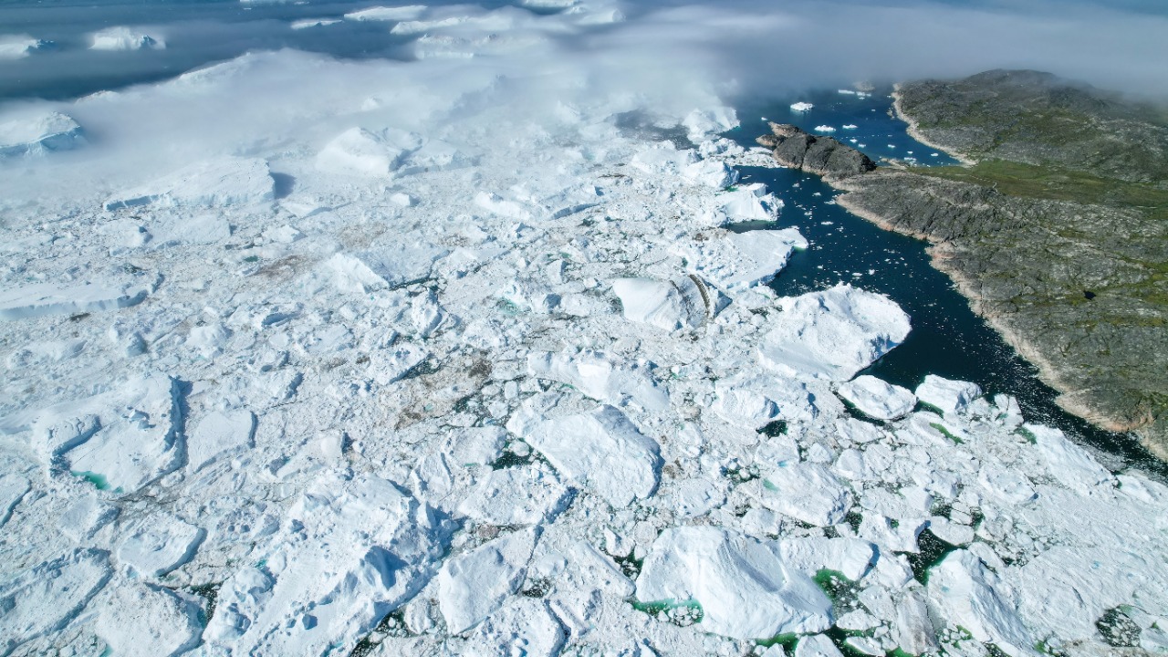
The day a Greenland fjord turned into a giant wave tank
The chain of events began when a huge slab of rock and ice broke loose above Dickson Fjord on the eastern edge of Greenland. On September 16, 2023, more than 25 million cubic yards of debris, enough to fill exactly 10,000 Olympic-size pools, thundered into the narrow waterway. The fjord, hemmed in by steep walls, had little room to absorb that sudden mass, so the water surface heaved upward into a towering crest that reached about 650 feet high, turning a quiet Arctic inlet into a vertical wall of sea.
Geologically, the mechanism was brutally simple. When the mountain fell, the plunging rock slammed into the seafloor like a giant piston, forcing water aside and up in a single violent pulse. That piston effect in Dickson Fjord, which sits along the sparsely populated eastern coast of Greenland, created a wave that raced outward, then rebounded off the fjord’s rock walls. With cliffs rising hundreds of feet on each side, the water had nowhere to dissipate its energy, so it began to oscillate, sloshing from one end of the fjord to the other like water in a shaken bathtub.
A 650-foot wave that would not die
What made this mega-tsunami extraordinary was not only its height but its persistence. The initial crest, a 650-foot wall of water, did not simply crash and fade. Instead, the wave energy became trapped between the fjord’s steep sides and shallow sills, setting up what physicists call a seiche, a standing wave that rocks back and forth at a natural frequency. In this case, the fjord’s dimensions tuned that frequency to roughly 92 seconds, so the water surface rose and fell in a slow, relentless rhythm.
Those oscillations continued for nine days, long after the dramatic splash had ended. Each cycle of the seiche pushed and pulled on the fjord floor, transmitting tiny but measurable stresses into the surrounding crust. Over time, that repeated loading acted like a hammer tapping the planet at regular intervals. The result was a low-frequency vibration that propagated through the solid Earth, a global signal that seismometers picked up as a mysterious, repeating pulse long before anyone knew it came from a remote corner of Greenland.
How scientists traced a global hum back to East Greenland
For seismologists, the signal that emerged in September 2023 was baffling. Instruments scattered across Earth began recording a repeating tremor that did not match the sharp onset of an earthquake or the slow build of a volcanic swarm. The pattern was too regular and too long-lasting. Only later did researchers connect that hum to a catastrophic landslide in an East Greenland fjord, where a mountaintop collapse had poured into the water and unleashed a 650-foot mega-tsunami. The investigation drew on a huge interdisciplinary and international effort, with teams combining seismic records, satellite imagery, and field surveys to reconstruct what happened in East Greenland.
One of the breakthroughs came from looking at the fjord not just as a source of shaking but as a resonant cavity. In September 2023, seismic detectors around the world captured the distinctive signature of the trapped waves, allowing scientists to image how the oscillating water column was driving the crust beneath Greenland. By matching the 92‑second period in the seismic data to the natural sloshing period of the fjord, they could show that the mega-tsunami’s lingering seiche was the metronome behind the global tremor. For me, that detective work underscores how tightly coupled the oceans and solid Earth really are, especially in confined basins where water has no easy escape route.
Climate change primed the slope that failed
Behind the drama of collapsing rock and ringing seismometers lies a slower, more unsettling driver: climate. The slope that failed above Dickson Fjord did not weaken overnight. Years of glacier retreat and permafrost thaw had been undermining the stability of the mountainside, loosening the bonds that held rock and ice in place. When the failure finally came, it was the culmination of long-term warming trends that have reshaped much of Greenland’s rugged coastline, leaving oversteepened slopes perched above deep water.
Recent analyses argue that the Dickson Fjord landslide was directly linked to climate‑induced glacier melting, which removed buttressing ice and allowed fractured rock to move. A massive landslide in Greenland‘s Dickson Fjord triggered a 200-metre-high wave and set off seiches that shook the planet for nine days, a chain of events that would have been far less likely without sustained warming. I see that as a stark example of how climate change is not just raising sea levels or altering weather patterns, but also loading the dice for rare, high‑impact disasters in places that once seemed too remote to matter to the rest of the world.
Satellites, seismometers and a new way to watch the oceans
What turned this event from a local catastrophe into a global scientific milestone was the technology that captured it. Using a brand-new type of satellite altimetry, researchers were able to watch the water surface in Dickson Fjord rise and fall by tens of centimetres in the days after the collapse, effectively turning orbiting instruments into remote tide gauges. That approach, developed by teams at Using advanced methods to interpret satellite altimetry data, allowed scientists to confirm that the same 92‑second oscillation seen in seismic records was also visible from space.
On the ground, dense networks of seismometers filled in the rest of the picture. A detailed reconstruction shared through an Earth-focused explainer shows how the trapped waves in the fjord generated a distinctive pattern of long-period seismic energy that could be traced across continents. For me, the most important lesson is that we are entering an era where satellites and seismology can work together to monitor extreme waves, storm surges, and even “freak” events in remote waters. As lead author Thomas Monahan of the University of Oxford has argued, Climate change is giving rise to new, unseen extremes in the oceans at the very moment when traditional physical sensors are limited, so learning to read these subtle planetary vibrations is becoming a crucial part of coastal risk awareness.
More from Morning Overview