The giant earthquake that ripped through central Myanmar earlier this year did something seismologists rarely see: it slid along a fault with almost eerie efficiency, converting tectonic strain into shaking with minimal frictional resistance. That “too smooth” motion is exactly what makes it so alarming for the United States, because the same kind of mature, straight fault geometry exists under California’s most infamous seismic threat. If Myanmar’s rupture is a preview, the next American “Big One” could be faster, longer, and more damaging than official scenarios currently assume.
Scientists now view the Myanmar event as a real-world experiment that played out along a fault strikingly similar to the San Andreas. The way the rupture raced along the fault, the distance it covered, and the way energy reached the surface are forcing a rethink of how bad a continental strike‑slip earthquake can be. For a country that has built millions of homes, freeways, and pipelines across its own version of that fault, the lesson is blunt: a smoother rupture is not a gentler one, it is a more efficient weapon.
Myanmar’s mega‑quake, in plain terms
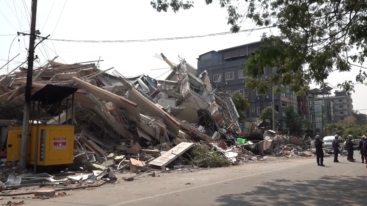
The Myanmar earthquake that now has seismologists on edge was a shallow, continental strike‑slip event that tore through the country’s heartland along a major fault. Detailed satellite and seismic analyses describe a moment magnitude of 7.7, with the rupture slicing past Mandalay and other densely populated areas. Unlike subduction megathrusts that dive under the ocean, this was a lateral tear through the crust, the kind of quake that can fling one side of a city several meters past the other in less than a minute.
What makes this event stand out is not only its size but its reach. Field and remote‑sensing work show that the rupture extended for roughly 510-kilometer along the Sagaing Fault, an almost unheard‑of length for a continental strike‑slip quake. That distance, combined with the shallow depth, meant that a vast swath of central Myanmar was exposed to intense shaking for an unusually long time, a worst‑case combination for infrastructure and emergency response.
A rare “ultra‑long” rupture that behaved too well
Seismologists classify the Myanmar event as an “ultra‑long” earthquake, a rupture that keeps propagating far beyond what standard models predict for its magnitude. Detailed waveform modeling shows that the fault slipped efficiently along its entire length, with the rupture front maintaining high speeds instead of sputtering out in segments. One research team described it as a rare, ultra‑long earthquake in Myanmar that revealed how a mature fault can deliver its full force directly to the surface.
That same work emphasizes that the quake “did everything scientists hoped to see” during a major continental rupture, not because it was benign, but because it exposed the upper limits of how efficiently a fault can fail. The rupture’s persistence and speed, documented in high‑resolution seismic records, show that once the fault let go, there were few internal barriers to slow it down, a pattern reinforced by follow‑up analysis of the ultra‑long rupture. For planners in the United States, that is the nightmare scenario: a fault that behaves not like a chain of smaller segments, but like a single, well‑oiled fracture.
The “trio of super factors” that made it supershear
Researchers digging into why the Myanmar quake ran so far and so fast have zeroed in on what one team calls a “trio of super factors.” First, the fault segment that broke was remarkably straight, which allowed the rupture front to accelerate without being deflected by bends or step‑overs. Second, the fault surface itself was unusually smooth at seismogenic depths, reducing friction and letting the slip transition into a supershear regime where the rupture speed exceeded the shear‑wave velocity of the surrounding rock. Third, the crust around the fault was relatively homogeneous, so the energy did not scatter as much as it might in a more chaotic geological setting, a combination laid out in a trio of super factors analysis.
Supershear ruptures are particularly dangerous because they can concentrate energy into a Mach‑cone‑like front, amplifying shaking in the direction of rupture. In Myanmar, that meant communities aligned with the direction of slip were hit by a sharper, more damaging pulse than standard hazard models would have predicted. A separate team, Using global seismic data, satellite radar (InSAR), and optical imagery, confirmed that this combination of straight geometry, smooth surfaces, and favorable crustal properties allowed the rupture to accelerate and persist in unusually dangerous ways. For California, where long, straight stretches of the San Andreas share similar traits, that trio is a warning label.
Sagaing Fault and San Andreas: familiar twins
The Myanmar quake did not happen on a random fracture. It tore along the Sagaing Fault, a major plate boundary that cuts through the country in a mostly straight north–south line. Geologists describe Sagaing Fault and San Andreas Connections, noting that The Sagaing Fault runs almost arrow‑straight through Myanmar, accommodating the lateral motion between the India and Eurasia plates. That geometry, combined with its length, makes it a near‑textbook analogue for California’s most famous fault.
In fact, one detailed comparison describes the Sagaing system as a “Fault With” a Familiar Twin The Sagaing Fault to the San Andreas, noting that it runs nearly straight from the Himalayas to the Andaman Sea, slicing through what one summary abbreviates as Mya. The famed San Andreas Fault in California is nearly identical in its basic mechanics, which is why the Myanmar rupture is now being treated as a full‑scale rehearsal for what could happen along the American fault.
Why “super smooth and efficient” is bad news
Field reports and seismic inversions describe the Myanmar rupture as “super smooth and efficient,” language that might sound reassuring until you understand what it means physically. A smooth, mature fault can let accumulated strain release in a single, coherent burst, with little of the energy wasted on grinding rock into powder or chewing through bends. One analysis of the Massive Myanmar earthquake notes that this efficiency allowed the rupture to deliver more of its energy directly into ground shaking at the surface, rather than dissipating it at depth.
Another study of the same event, framed as a 500-kilometer earthquake, quotes researcher Lindsey saying that on mature, smooth faults, the energy is highly focused and comes right to the surface. That is the core of the problem for the United States: long, well‑developed sections of the San Andreas share that maturity, which means that if they go, they may not produce a patchwork of moderate quakes, but a single, highly efficient rupture that sends concentrated shaking into cities from Los Angeles to the Bay Area.
California’s tectonic setup mirrors Myanmar’s
Myanmar’s seismic vulnerability is rooted in its position between two colliding plates, a setting that has clear parallels in the western United States. Geologists describe What lies beneath the surface in Myanmar, noting that the country sits between the India and Eurasia plates, which grind past and under each other in a complex dance of strike‑slip and thrust faults. That tectonic squeeze is what loads the Sagaing Fault with strain, setting the stage for large, shallow earthquakes.
California, for its part, sits astride the boundary between the Pacific and North American plates, with the San Andreas accommodating much of the lateral motion. One detailed comparison bluntly states that the Myanmar event “should be a wake‑up call for California,” precisely because the San Andreas Fault is nearly identical to the one that just ruptured. The implication is that the same tectonic recipe that produced a 7.7, 510‑kilometer supershear rupture in Myanmar exists under America’s most populous state.
What the Myanmar rupture says about the U.S. “Big One”
For decades, U.S. hazard models have been built around historical events like the 1906 San Francisco earthquake, when a rupture in the northern section of the San Andreas produced a magnitude 7.9 event that killed more than 3,000 people, according to the U.S. Geological Survey. Those scenarios typically assume that future ruptures will be limited by bends and step‑overs along the fault, keeping them shorter and somewhat less efficient than the theoretical maximum. The Myanmar quake challenges that assumption by showing that a long, straight, mature fault can break in one go, with little or no vertical movement but devastating lateral slip, a pattern that one analysis notes geologists were expecting on the Sagaing Fault but were still surprised by when it actually happened.
Several recent assessments now argue that San Andreas fault earthquakes may be significantly larger in the future than previously modeled, precisely because of the Myanmar precedent. Another overview framed as “A Mega‑Quake Shocked Myanmar. Could California Be Next?” lays out how the Sagaing rupture demonstrates the possibility of a multi‑hundred‑kilometer, supershear event on the San Andreas that would link segments once thought likely to fail separately. For the United States, that means the “Big One” might not just be a repeat of 1906, but something longer, faster, and more punishing to modern infrastructure.
Scientists’ evolving view, from Mandalay to Los Angeles
Seismologists have been unusually candid about how much the Myanmar event is reshaping their thinking. In one televised breakdown, John Colin Mutter, a seismologist and professor of earth and environmental sciences at Columbia University, walked through how the rupture’s length, shallow depth, and supershear characteristics combined to produce such widespread damage. He emphasized that the quake’s behavior was not a freak outlier, but a manifestation of what mature strike‑slip faults are capable of when conditions line up, a point that resonates uncomfortably when applied to the San Andreas.
Peer‑reviewed work on the 28 March 2025 MW7.7 Myanmar earthquake uses InSAR and other remote‑sensing tools to map the rupture in fine detail, providing a template for how scientists might analyze a future California event from orbit if ground access is cut off. That same integrated approach, combining satellite radar, optical imagery, and global seismic networks, is now being used to refine U.S. hazard models, with researchers explicitly citing the Myanmar rupture as a case study in how long, smooth faults can fail. From Mandalay’s shattered neighborhoods to the freeways of Los Angeles, the scientific message is consistent: the physics does not respect national borders.
What this means for U.S. policy and preparedness
For the United States, the Myanmar quake is less a distant tragedy than a stress test of its own assumptions. If a 7.7, 510‑kilometer supershear rupture is possible on a San Andreas‑like fault in Asia, then it is physically plausible on the San Andreas itself, which cuts through or near cities that are central to the national economy. That raises hard questions for building codes, retrofitting priorities, and the design of lifeline infrastructure such as aqueducts, gas pipelines, and high‑voltage transmission lines that cross the fault. The Myanmar event shows that a single, efficient rupture can disrupt a region’s core systems for months, a scenario U.S. planners must now treat as more than a theoretical worst case.
At the same time, the detailed scientific work on the Myanmar quake offers tools as well as warnings. The integrated use of global seismic data, InSAR, and optical imagery, as highlighted in the UCLA study, is already being folded into U.S. early‑response planning, so that agencies can rapidly map rupture extent and ground deformation after a major event. Analyses like the Myanmar–California comparison and the Myanmar quake hints piece are already filtering into policy conversations about how to update “Big One” scenarios. The core takeaway is stark: a fault that moves “too smoothly” is not a sign of a gentle release, it is a signal that when it finally breaks, it may do so in the most efficient, and therefore most destructive, way possible.
More from MorningOverview