Deep beneath Greenland’s vast ice sheet, scientists are uncovering a hidden source of heat that could accelerate melting and unsettle long term sea level projections. New three dimensional models of the rock and mantle below the island suggest that the ice is not resting on a uniform deep freeze, but on a patchwork of warmer and cooler zones that subtly lubricate its base and change how it flows. If those findings hold up, the world’s coastal cities may need to rethink how quickly seas can rise and how soon defenses must be built.
I see this discovery as a reminder that climate risk is not just about what happens in the atmosphere, but also about how the solid Earth and ancient ice interact in ways we are only beginning to resolve. The physics of that interaction is complex, yet the stakes are simple: hundreds of millions of people live in places that depend on accurate sea level forecasts, and hidden heat under Greenland could shift those numbers in ways current planning does not fully capture.
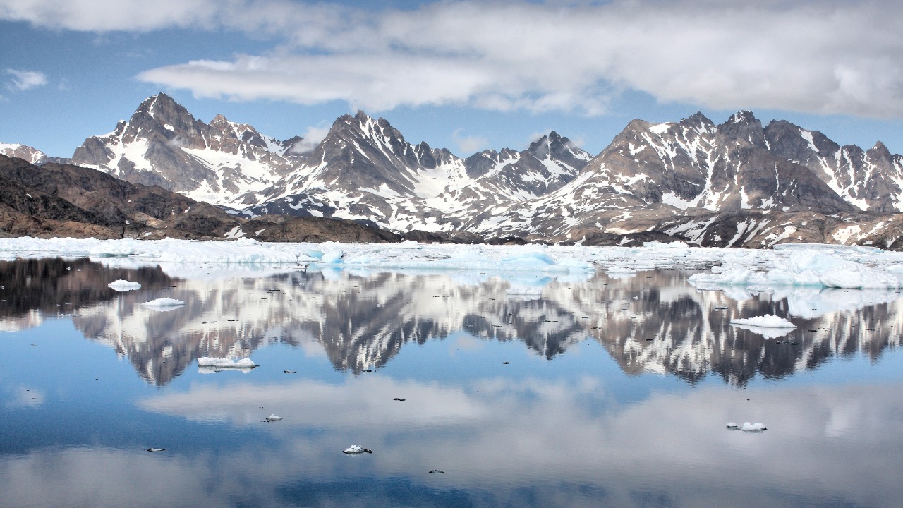
Greenland’s ice sheet was already a global risk
Before anyone started talking about underground heat, Greenland’s ice sheet was already one of the largest contributors to rising oceans. The ice cap stores enough frozen water to raise global sea level by several meters if it were lost, and its outlet glaciers are already calving icebergs into fjords in southeastern Greenland, as seen in an Aug file image of a glacier front that has become emblematic of rapid change. Analysis of the ice sheet’s recent behavior shows that melting of Greenland’s ice sheet is exposing more areas to melting temperatures and feeding a steady increase in ocean volume that is now baked into long term projections.
Those projections sit within a broader scientific consensus that global warming is driving thermal expansion of seawater and the loss of land ice worldwide, a picture synthesized in assessments from the Intergovernmental Panel on Climate Change. Work focused specifically on the Greenland Ice Sheet, sea level rise, and coastal communities has highlighted how even modest additional centimeters of water can amplify storm surge and erosion for low lying neighborhoods, from small Arctic settlements to major ports. The Belfer Center’s analysis of the Greenland Ice Sheet, sea level rise, and coastal communities notes that as more of the ice surface crosses the threshold into melt season conditions, the downstream effect is a higher baseline for coastal flooding risk in every ocean basin.
A buried heat source comes into focus
The new twist is that Dec Scientists studying Greenland have built the most detailed three dimensional models yet of temperatures deep beneath the island, revealing that the bedrock and mantle are far from uniform. Instead of a simple cold foundation, the models show uneven pockets of warmth that can trap heat beneath parts of the ice sheet and subtly change how it moves and melts. By combining seismic data, gravity measurements, and ice flow observations, the researchers have mapped how this hidden heat varies from one region to another, suggesting that some outlet glaciers may be sitting atop warmer, more deformable rock than others.
According to reporting on Scientists have built the most detailed 3D models of temperatures beneath Greenland, this work indicates that the ice sheet’s base is influenced by geothermal heat that had been poorly constrained in earlier models. Dec Scientists involved in the project describe how these warmer zones can increase basal sliding, effectively greasing the underside of the ice and allowing it to respond more quickly to surface warming and ocean intrusion. That means the deep Earth, not just the atmosphere and ocean, is now part of the story of how fast Greenland can change.
Trapped heat and faster ice motion
What makes this discovery so consequential is not just that there is heat under the ice, but that it appears to be trapped in ways that directly affect ice sheet motion. Dec Scientists have identified zones where geothermal energy accumulates beneath Greenland, warming the base of the ice and promoting the formation of meltwater that can act as a lubricant. When that water pools at the interface between ice and rock, it can reduce friction and allow large sections of the ice sheet to slide more readily toward the coast, feeding outlet glaciers and increasing the rate at which ice is discharged into the ocean.
Reporting from The Brighter describes how Scientists find trapped heat beneath Greenland that is already impacting ice sheet motion and future sea level change. The Brighter notes that this subsurface warmth is not evenly distributed, which helps explain why some glaciers accelerate while others remain comparatively stable even under similar atmospheric conditions. For planners who have treated Greenland as a single, monolithic block of ice, the implication is clear: local geology matters, and some sectors of the ice sheet may be primed for faster change than global models currently assume.
3D modeling of Earth’s interior advances our understanding
To get at these hidden processes, researchers have turned to sophisticated three dimensional modeling of Earth’s interior that would have been impossible a generation ago. Dec Scientists studying Greenland have used seismic waves, gravity anomalies, and ice flow data to reconstruct how heat moves from deep within Earth toward the base of the ice, capturing variations tied to mantle plumes, crustal thickness, and long term tectonic history. By resolving these details, the models can show where the bed is likely to be warm enough for ice to slide, and where it remains locked to the rock by cold, rigid conditions.
Coverage of this work emphasizes that such 3D modeling of Earth’s interior advances our understanding of how Greenland’s ice sheet interacts with the solid planet beneath it. The Cool Down notes that Scientists studying Greenland have uncovered not only temperature variations but also the role of processes such as glacial isostatic adjustment, in which the crust slowly rebounds as ice mass is lost. That rebound can change stress patterns and potentially alter how and where geothermal heat reaches the ice base, adding another layer of complexity to projections of future behavior.
Why this matters for sea level rise forecasts
For coastal communities, the key question is not just how much ice Greenland will lose, but how quickly that loss will occur. Earlier this year, Dec reporting framed the new findings in stark terms, asking Why this finding is important at a moment when Greenland’s ice sheet is already one of the largest contributors to rising sea levels worldwide. If hidden heat is making parts of the ice sheet more responsive to surface warming, then timelines for sea level rise that once seemed conservative may now be underestimating the pace of change, especially in sectors where basal sliding is enhanced.
As one analysis put it, understanding why Greenland behaves the way it does helps societies prepare for what lies ahead, from redesigning coastal infrastructure to revising flood maps and insurance models. The Yahoo report on Why this finding is important stresses that the discovery of uneven underground temperatures is not an abstract curiosity, but a factor that can shift real world risk calculations. When combined with satellite records of accelerating ice loss and ocean monitoring, it suggests that the envelope of plausible sea level outcomes may be wider, and skewed toward faster rise, than many coastal planners have assumed.
Mapping hidden heat and improving projections
The effort to turn these geophysical insights into better forecasts has centered on detailed mapping of the subsurface. A project described as Mapping Hidden Heat Beneath Greenland was carried out at the University of Ottawa in partnership with researchers who specialize in ice dynamics and solid Earth physics. By integrating seismic tomography with ice sheet models, the team has been able to produce high resolution maps of geothermal flux that can be plugged directly into simulations of how Greenland will respond to different warming scenarios, rather than relying on crude, uniform assumptions.
According to a Dec account of Mapping Hidden Heat Beneath Greenland, the University of Ottawa led work is explicitly aimed at Improving Predictions of Future Sea Level Rise by better capturing how heat inside Earth interacts with ice. A related discussion of Improving Predictions of Future Sea Level Rise notes that by refining estimates of Greenland’s contribution to global sea level rise, these models can feed directly into the main documents used by policy makers, including national adaptation plans and international climate assessments. In practical terms, that means the hidden heat maps are not just scientific curiosities, but inputs that can change the numbers in coastal risk spreadsheets from Rotterdam to Miami.
Signals of a sudden threat and public perception
As the technical work has progressed, the story of Greenland’s buried heat has also spilled into public discourse, sometimes with more urgency than nuance. A widely shared Dec video titled Greenland Discovery Signals Sudden Sea Level Threat framed the findings as evidence that intense heat beneath Greenland could trigger rapid, perhaps abrupt, changes in the ice sheet. In that clip, Scientists are shown explaining that Greenland’s interior is warmer than expected, and the narration links this directly to fears of sudden jumps in sea level that could catch coastal communities off guard.
The Facebook post that promoted Greenland Discovery Signals Sudden Sea Level Threat uses dramatic language and imagery to convey the stakes, highlighting hashtags such as IceSheet, Geophysics, EarthChanges, and BreakingResearch. While the underlying science does point to a more sensitive ice sheet, the leap from enhanced basal heat to immediate catastrophe is not fully supported by the available sources. Unverified based on available sources are any claims that the new findings alone imply an imminent, step change collapse, yet the public reaction underscores how discoveries in Greenland resonate far beyond the scientific community.
What satellites and global records already show
Even without the new geothermal maps, the trajectory of global sea level has been unmistakable. NASA satellite data from 1993 to the present day, spanning more than 30 years, show a clear upward trend in global mean sea level, with the rate of rise increasing as ice sheets and glaciers lose mass and oceans absorb more heat. Those records, compiled and explained through resources that aggregate NASA sea level rise links, provide the baseline against which any new contribution from Greenland’s hidden heat must be measured.
At the same time, detailed observations of Greenland’s surface and edges have become routine. In the modern era, we take for granted satellite data that can tell us almost instantly what percentage of the ice sheet is melting on a given summer day, information curated by institutions such as the National Snow and Ice Data Center. A feature titled In the Greenland’s Melting Ice, A Warning on Hard Climate Choices, notes that this near real time view has already revealed episodes when surface meltwater rapidly drains to the bed, temporarily speeding up ice flow. The new geothermal findings suggest that where that water ends up, and how long it stays liquid, may depend heavily on the deep heat patterns now being mapped.
From research to policy: integrating hidden heat into planning
Turning these insights into action will require more than just better models, it will demand a tighter link between the research community and those who write the rules and budgets for coastal adaptation. Programs such as the NERC Ice Sheet Stability Programme, known as iSTAR, offer a template for how that can work. iSTAR scientists will be working together to engage with the scientific community on sea level projection to make sure that the latest understanding of ice dynamics, including factors like basal heat, is reflected in the main document used by policy makers when they plan for future risk.
The description of iSTAR scientists underscores that this is not just an academic exercise, but a deliberate effort to translate complex glaciology into numbers that finance ministries, city planners, and disaster agencies can use. As hidden heat beneath Greenland is incorporated into projections, I expect to see its influence show up in revised sea level scenarios in future assessments, including those coordinated by bodies like the Intergovernmental Panel on Climate Change. For coastal communities weighing whether to build higher seawalls, retreat from vulnerable zones, or redesign drainage systems, the message is that the ground truth under Greenland is shifting, and with it, the timelines they must plan against.
More from MorningOverview