Over the next decade, rising oceans are poised to redraw the edges of some of the world’s best known coastal cities, turning today’s “once in a century” floods into regular events and pushing salt water into streets, subways, and drinking water systems. By 2035, the combination of higher seas and sinking land will leave planners in places from Miami to Jakarta making hard choices about which neighborhoods to defend, which to elevate, and which to surrender to the tide.
I see the next ten years as a stress test for coastal civilization: enough time for sea level rise to become impossible to ignore, but not enough for slow political systems to fully catch up. The science is clear that oceans will keep climbing for generations, yet the shape of cities in 2035 will depend on decisions taken now about infrastructure, zoning, and emissions.
The science behind a 2035 coastal tipping point
Global sea level is not rising in a straight, gentle line. Warmer oceans expand, land ice melts, and in many deltas and coastal plains the ground itself is subsiding, which means local water levels can climb far faster than the global average. A major assessment on The Next 30 Years of Sea Level Rise along the U.S. coastline projects an average increase of 10 to 12 inches by the early 2050s, effectively stacking an extra foot of water under every storm and high tide. That kind of background rise turns today’s nuisance flooding into chronic inundation, especially in low lying neighborhoods built barely above current sea level.
Some coastal advocates warn that a sea level rise of three feet is “very probable” by 2100, with a range of “2m +/- 1m” possible by 2050, a scenario that would significantly reshape shorelines unless emissions are curbed and local defenses strengthened. In California, a briefing on The Issue of sea level rise stresses that even intermediate projections would disrupt ports, highways, and groundwater unless impacts are “mitigated by reducing emissions.” When I look at those numbers through a 2035 lens, the message is blunt: the next decade is not about distant hypotheticals, it is about managing a rapid transition from sporadic flooding to a new coastal normal.
Mapping the new shoreline: tools that show what is coming
For city planners and homeowners, the most sobering evidence is not in abstract graphs but in maps that show which streets and buildings sit in the future flood zone. In the United States, one of the most widely used tools is the Sea Level Rise Viewer, which lets users dial in different water levels and see how far tides would reach into their communities. The platform includes detailed Fly Through Scenarios for places like Biloxi, Mississippi at zero, six, and ten feet of sea level rise, turning abstract projections into a visceral sense of what neighborhoods could be lost.
Another influential platform, Surging Seas, uses elevation, tides, and population data to highlight areas at risk from different combinations of sea level rise and storm surge. Its Introduction explains that the Risk Zone maps focus on near term flooding potential, layering in population density and property value to show where damage would be most severe. When I overlay those maps with city boundaries, the pattern is stark: by the mid 2030s, many iconic waterfronts are less a fixed line on a chart than a moving frontier between land and sea.
U.S. cities already on the front line
Scientists have been blunt that some American cities face serious trouble on a 2035 timeline. One study cited by Scientists listed coastal communities expected to be “inundated by 2035,” and warned that more would join the list within the next “50, 80” years if emissions remain high. A separate analysis shared in News found that the fastest rates of sea level rise are occurring in Gulf states like Texas and Louisiana, while many East Coast communities are also seeing water levels climb faster than the global average. That combination of subsiding land and rising seas is already visible in places like New Orleans, where levees and pumps are constantly tested by higher baselines.
Maps of future inundation show that some resort towns could be almost unrecognizable by mid century. A widely shared projection highlighted how Atlantic City in New Jersey and nearby Ocean City could be largely submerged if seas rise several feet, with some neighborhoods “completely destroyed” and others “flooded with sea water.” Smaller communities like Rockport on the Texas coast and Grand Isle, Louisiana already sit precariously close to sea level, so even modest additional rise by 2035 will magnify the impact of every hurricane and king tide.
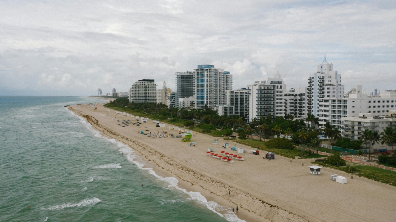
Miami and the paradox of booming growth in a sinking city
Few places capture the contradictions of coastal risk like Miami. The city sits on porous limestone, which means water can seep up from below even when seawalls are high, and its low lying neighborhoods already endure frequent “sunny day” flooding. An analysis of the five riskiest U.S. cities for coastal flooding noted that Miami in Florida faces flooding not just from storms and high tides but also from water rising through that limestone foundation. By 2035, even a foot of additional sea level could turn parts of the city into a patchwork of dry islands and regularly flooded streets.
Yet property markets in nearby Miami Beach remain red hot. A report on celebrity real estate noted that Wealthy buyers continue to flock to the area despite dire predictions about sea level rise expected by the year 2030. That disconnect between short term optimism and long term risk is exactly why I see the 2035 horizon as so important: it is close enough that today’s mortgages and infrastructure bonds will still be active, yet far enough that the full impact of higher seas will only just be unfolding.
Jakarta, Bangkok and Ho Chi Minh City: Southeast Asia’s sinking megacities
In Southeast Asia, the challenge is not only rising seas but also rapidly sinking land. In Jakarta, decades of groundwater extraction have caused parts of the city to subside at alarming rates. A planning study on adaptation to flood risk reported that Lobo predicted the inundated area of Jakarta would increase 50.21% by 2035, with “half of Jakarta” projected to be inundated by a combination of land subsidence and growing rising sea water. When I consider that figure, it is hard to escape the conclusion that parts of the current capital are on track to become uninhabitable within a single generation.
Bangkok faces a similar squeeze. One global review of Sea Level Rise Projections warned that Bangkok, Thailand is among the world’s most vulnerable capitals as sea encroachment “is expected to get worse.” Another assessment noted that Bangkok is sinking at a rate of more than 1 centimeter a year and could be below sea level by 2030. A separate list of at risk cities pointed out that But Bangkok is also built on very dense clay soil, which makes it more prone to flooding, and warned that by 2030 most of the coastal districts could be underwater, as could its main airport, Suvarnabhumi International. When I extend those trends to 2035, the picture is of a megacity racing to raise roads and build barriers just to keep pace with the sinking ground.
Further down the coast, Ho Chi Minh City sits in the low lying Mekong delta, where sea level rise and upstream dams are already reshaping sediment flows. Regional analyses of Sea level impacts highlight the city as another hotspot where even modest additional rise could push salt water far inland. By 2035, without aggressive adaptation, I expect the combined effect of higher tides and heavier monsoon rains to force difficult decisions about which districts to fortify and which to gradually retreat from.
Atlantic and Gulf hubs: Norfolk, Charleston and New Orleans
On the U.S. Atlantic seaboard, historic port cities are discovering that their charm comes with a growing flood bill. In Norfolk, Virginia, home to a major naval base, recurrent tidal flooding already disrupts roads and neighborhoods, and sea level rise projections suggest that by the 2030s some low lying blocks could be underwater during routine high tides. Farther south, Charleston, South Carolina has seen a sharp increase in so called nuisance floods that close streets and damage historic buildings, a trend that will accelerate as seas climb another several inches.
In the Gulf, the stakes are even higher because subsidence compounds global sea level rise. New Orleans already relies on levees and pumps to stay dry, and projections used in federal planning show that by 2035, higher baselines will leave less room for error when storms push water toward the city. Small barrier island communities like Grand Isle, Louisiana are even more exposed, with some scenarios suggesting that repeated storm damage and chronic flooding could make long term habitation untenable.
California’s coastal icons: San Francisco and San Diego
On the Pacific coast, sea level rise is slower than in the Gulf but still fast enough to threaten infrastructure that was never designed for a higher ocean. A recent analysis of a California flood risk map warned that Large cities face rising sea levels along the coast despite the state’s climate change defenses, and that new data show how unchecked sea level rise could damage the state’s infrastructure. In San Francisco, that means waterfront freeways, light rail lines, and low lying neighborhoods around the bay are all in the crosshairs as tides creep higher.
Farther south, San Diego faces a different but related set of challenges. Its beaches and coastal bluffs are central to the local economy, yet higher seas will accelerate erosion and push storm waves closer to rail lines and highways that hug the shore. A statewide overview of The Issue of sea level rise in California underscores that even a three foot rise, which is described as “very probable” by 2100, would inundate large stretches of coastline and that impacts could arrive much earlier in low lying pockets. By 2035, I expect both cities to be deep into expensive debates over which seawalls to raise, which roads to relocate, and how to protect critical wastewater and power infrastructure from salt water.
How cities are adapting, and what 2035 will test
Urban adaptation is no longer a theoretical exercise, it is a line item in city budgets. In the United States, coastal planners are using tools like the Sea Level Rise Viewer and Surging Seas Risk Zone maps to prioritize which neighborhoods need new drainage, raised roads, or buyout programs. The Introduction to those Risk Zone tools emphasizes that they combine elevation, population density, and property value, which helps local governments weigh the cost of defenses against the potential damage. In my view, the cities that fare best by 2035 will be those that treat these maps not as worst case curiosities but as blueprints for zoning, insurance, and infrastructure.
Education and public awareness are also shifting. A learning resource that invites viewers to Join Jack Black as he meets climate scientists at the University of Miami to analyze the possible effects of sea level rise on coastal cities underscores that even if greenhouse gas emissions stopped increasing, the oceans would keep rising for decades because of heat already stored in the system. That lag means adaptation is unavoidable. By 2035, I expect the political debate to shift from whether to adapt to how fast and who pays, as more residents see flood maps line up with water in their streets.
What a redrawn coastal map means for people and power
Behind every contour line on a sea level map are homes, jobs, and cultural landmarks. A global list of Sea Level Rise Projections for at risk cities makes clear that places like Bangkok, Jakarta, Ho Chi Minh City, Miami, and New Orleans are not fringe settlements but economic engines and cultural capitals. As seas rise, some districts will be protected with walls and pumps, others will be elevated, and some will be gradually abandoned, shifting population and political power inland. A widely circulated map showing that a “significant proportion” of North American coastal cities could be underwater, with some cities “completely destroyed,” is a blunt reminder that the stakes are not just about occasional floods but about whether entire communities can remain where they are.
By 2035, I expect the phrase “redrawing the map” to be more than a metaphor. Insurance markets will have retreated from some high risk zones, public housing authorities will be weighing relocation, and debates over seawalls in places like San Francisco, San Diego, Norfolk, Virginia, and Charleston, South Carolina will have moved from engineering drawings to construction sites. The choices leaders make now, informed by tools like Sea Level Rise Viewer and Surging Seas, will determine whether those new coastlines are the product of chaotic retreat or planned adaptation.
More from MorningOverview