Miami’s glittering skyline has always been framed by water, but new research suggests the ground beneath some of those towers is quietly dropping faster than many experts anticipated. A detailed satellite analysis of coastal high-rises now points to dozens of structures that are not just coping with rising seas, but also with land that is slowly sinking beneath their foundations. The findings sharpen long-standing worries about how a low-lying, heavily built coastline will hold up as climate pressures intensify.
I see this work as a turning point in how the region thinks about risk: not as a distant climate abstraction, but as a measurable shift in the elevation of specific buildings people live and vacation in every day. The study’s focus on luxury condos and hotels along some of the most valuable stretches of shoreline makes the stakes impossible to ignore, for residents, investors, and local governments alike.
What the new subsidence study actually found
The latest analysis from the Univers team zeroed in on coastal structures and identified a clear pattern: a cluster of high-rises along the Atlantic edge of South Florida is experiencing measurable subsidence. Using satellite radar to track tiny changes in elevation over several years, the researchers flagged 35 specific buildings where the ground is settling. In each case, the land under the structure is moving, not in a sudden jolt, but through a slow process that can continue for many years and subtly change how a building bears its own weight.
Those 35 buildings include some of the most recognizable luxury condos and hotels in the region, with measurements showing that parts of their sites have sunk by as much as three inches over the study period. Earlier reporting described how the researchers focused on beachfront properties that rose between 2016 and 2023, then compared their movement to nearby stable reference points to isolate true ground settlement. Experts quoted in the coverage called the pattern “unexpected,” not because engineers assumed the land was perfectly still, but because the rate and concentration of movement in such high-profile locations had not been fully appreciated before.
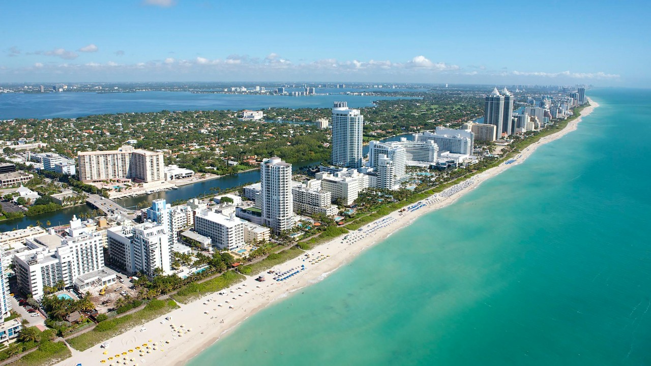
Dozens of Miami luxury towers in the spotlight
The most eye-catching part of the findings is the roster of affected buildings, which includes Dozens of high-end condos and hotels in MIAMI and neighboring coastal cities. These are not anonymous mid-rises tucked inland, but glassy towers that market ocean views and resort-style amenities, often with price tags to match. The study’s authors singled out a string of properties along the sand where subsidence rates were higher than expected, raising questions about how those buildings will perform as sea level rise and storm surge add more stress.
Coverage of the research has highlighted how many of the flagged structures sit in a relatively narrow band of shoreline, north and south of central Miami. One report described how these Scientists-identified hotspots line up with some of the region’s most heavily marketed addresses, where buyers may have assumed that newer construction automatically meant lower risk. Instead, the data suggest that even relatively recent towers can be affected when the underlying geology and construction history line up in the wrong way.
Why Miami’s ground is giving way
To understand why these buildings are settling, it helps to look beneath the surface. Much of the urbanized coast sits on limestone and other porous materials that can dissolve, erode, or compact over time. In a recent public discussion, researcher Falk Amelung described how limestone can contain caves and holes that gradually change as water moves through them, creating voids or weak spots. When a heavy high-rise is placed on top of that kind of substrate, even small shifts can translate into measurable subsidence at the surface.
The new work on subsidence hotspots in South Florida adds another layer, pointing to how construction practices and vibrations from nearby projects can contribute to gradual settlement. While builders try to minimize those forces, the combination of heavy loads, changing groundwater, and a complex subsurface can still produce slow downward movement. Earlier regional research, summarized in a separate analysis of how land subsidence magnifies sea level rise, warned that this one-two punch could turn what looks like a manageable amount of flooding on paper into a much larger problem on the ground.
The one-two punch with rising seas
Even if the land were perfectly stable, Miami’s low elevation would make it vulnerable to higher tides and stronger storms. What the new findings underscore is that the baseline is not fixed. When the ground under a building sinks, even by fractions of an inch per year, it effectively accelerates the impact of sea level rise for that specific site. Earlier regional modeling, described in a Nature-focused report, showed how combining modest land subsidence with projected ocean levels could leave far more property flooded by mid century than sea level alone would suggest.
That context matters for the Nearly three dozen high-rises now identified as sinking or settling. A tower that was designed with a certain flood elevation in mind may find that its effective height above water shrinks faster than planners anticipated, especially if subsidence is uneven across a site. I see this as a shift from thinking about climate risk in broad maps to thinking about it building by building, where a few extra centimeters of downward movement can change how a structure experiences king tides, storm surge, or even routine heavy rain.
How fast are the buildings sinking?
The study’s measurements show a range of subsidence rates, with some buildings moving only slightly and others settling more quickly. One synthesis of the findings reported that the researchers saw subsidence ranging between roughly 0.8 millimeters per year and higher values that, over several years, added up to multiple inches of movement. Another account emphasized that some of the Friday-highlighted buildings had sunk by as much as three inches between 2016 and 2023, a pace that surprised even seasoned observers.
It is important to stress that subsidence alone does not mean a building is unsafe. Engineers routinely design for some settlement, especially in soft or variable soils, and the new research does not claim that all of the identified towers are at imminent risk. What it does show, through detailed satellite tracking and cross checks with University of Miami field work in South Florida, is that the ground under certain properties is moving in ways that merit closer inspection. I read the numbers less as a verdict and more as a screening tool, a way to prioritize where detailed structural assessments should happen first.
Surfside’s shadow and the question of safety
Any discussion of sinking high-rises in South Florida inevitably unfolds in the shadow of the Surfside condo collapse, even when researchers are careful not to draw direct lines. The new subsidence work explicitly references how South Florida engineers have spent years grappling with how much multi story buildings can safely settle, and how to interpret small but persistent movements in the context of aging structures. A separate Miami Herald investigation described how professionals have debated the thresholds that should trigger deeper inspections, especially in older towers that predate modern codes.
In that light, the new satellite-based findings are both reassuring and unsettling. On one hand, they give regulators and building owners a powerful new tool to spot potential trouble early, long before cracks or tilts become obvious. On the other, they reveal that some of the region’s most prominent towers are already moving more than expected, which raises difficult questions about long term maintenance and retrofits. I find it telling that follow up coverage has focused not just on the raw numbers, but on how local governments might integrate this kind of data into recertification programs and emergency planning.
Spotlight on specific properties and neighborhoods
Although the study did not single out every building by name in public summaries, subsequent reporting has zeroed in on several marquee properties. One widely shared piece asked bluntly, What Lies Beneath some of the most recognizable towers, framing the issue as “Miami Buildings Are Sinking, Is Yours One of Them?” That framing captured the anxiety of owners who suddenly found their addresses mentioned in technical discussions of ground movement, even when engineers stressed that the observed subsidence did not automatically translate into structural danger.
Beyond individual towers, the research points to geographic clusters where subsidence is more pronounced. Some of those hotspots line up with well known stretches of Miami Beach, while others appear in neighboring barrier islands and coastal neighborhoods. Additional mapping work has highlighted how parts of Sunny Isles, Bal Harbour, and Surfside share similar subsurface conditions, which may help explain why certain blocks show more movement than others. For residents, that means the story is not just about a few headline grabbing towers, but about the broader fabric of neighborhoods built on shifting ground.
What engineers and officials can do next
The immediate question for local leaders is how to translate these findings into action without causing unnecessary panic. One practical step is to fold satellite based subsidence data into existing building recertification processes, so that towers showing faster movement receive more frequent or more detailed inspections. The New study’s emphasis on using stable structures as reference points offers a template for how cities might build their own monitoring systems, combining satellite data with on the ground sensors and engineering assessments.
There is also a policy dimension that goes beyond any single building. Regional analyses of how land subsidence magnifies sea level rise suggest that zoning, infrastructure planning, and even insurance rules may need to account for changing ground elevations. I see a strong case for creating public facing maps that show not just flood zones, but also measured subsidence rates, so buyers and renters can make informed decisions. That kind of transparency will not stop the ground from moving, but it can help align private choices with the physical realities that the new research has brought into sharper focus.
More from MorningOverview