Across the United States, a highly unusual winter setup is colliding with peak holiday travel, raising the odds that long‑standing temperature and snow records will fall in rapid succession. Meteorologists are tracking a pattern that favors almost summerlike warmth for millions while unleashing disruptive storms on both coasts, a combination that is rare for late December and potentially historic in scope. The stakes range from shattered “white Christmas” expectations to dangerous flooding and travel chaos, all unfolding as forecasters warn that this is not a one‑day fluke but part of a broader, volatile season.
The rare pattern that has forecasters on alert
In recent days, a prominent Dec meteorologist has urged viewers to “get ready” for what he describes as an extremely rare winter pattern capable of toppling temperature records across large swaths of the country. His warning centers on a setup in which warm, subtropical air surges unusually far north at the same time that cold air is bottled up, a configuration that sharply tilts the odds toward record highs instead of the deep freezes many Americans associate with late December. In his earlier forecast, he emphasized that this is not just a mild spell but a configuration that could leave snowpack struggling to survive even in places that had fresh snow on the ground a few days earlier, a sign of how aggressive the warm push may be.
What makes this pattern stand out is not only its intensity but its timing, arriving just as families are counting on predictable winter conditions for travel and holiday traditions. The Dec meteorologist’s call to “get ready” reflects concern that communities may underestimate how quickly temperatures can spike and how thoroughly the warmth can erase recent snowfall, especially when it follows a colder stretch earlier in the season. His description of an “extremely rare winter pattern” underscores that this is not the typical back‑and‑forth of seasonal weather but a configuration that, if it locks in for several days, could shatter records across multiple states at once.
How the setup could smash temperature records
At the heart of the looming warmth is a strong ridge of high pressure that is poised to dominate the central and eastern United States, a feature that effectively acts like a heat pump in the middle of winter. As air sinks beneath this ridge, it compresses and warms, allowing temperatures to soar well above seasonal norms and, in some cases, challenge all‑time December records. Forecasters expect this ridge to be both expansive and stubborn, a combination that can keep daytime highs elevated and overnight lows unusually mild, a recipe for record‑breaking streaks rather than a single warm afternoon.
In a widely shared Dec Video Transcript, one forecaster walked viewers through model projections that show temperatures surging into the 50s and 60s for high temperature readings in areas that would typically be bracing for snow and ice. He highlighted that as we go into Christmas Day, this pattern could deliver readings that feel more like early spring than the heart of winter, with the potential for dozens of locations to challenge or exceed their warmest Christmas values on record. The emphasis on 50s and 60s for high temperature forecasts is not just a curiosity, it is a concrete signal that the atmosphere is primed to smash records in places where residents are more accustomed to shovels than short sleeves at this time of year.
What is causing the warmup across the country
To understand why this winter looks so different, it helps to zoom out to the large‑scale drivers that are steering the atmosphere. A key factor is a pronounced ridge of high pressure stretching across the central and eastern United States, which is funneling warm, moist air northward from the Gulf of Mexico and the subtropics. This ridge is effectively blocking colder Arctic air from plunging south, leaving much of the country under a dome of warmth that can persist for days and keep temperatures elevated even overnight, when radiational cooling would normally bring a sharper chill.
Analysts describe this ridge as the central feature in what is Causing The Warmup, a pattern that is expected to make Christmas the warmest on record for millions of Americans. Under this setup, forecast highs and lows are projected to run far above average, with the warmest anomalies centered from the Plains into the East, while only a few pockets of the West and far North hang on to more typical winter readings. One detailed breakdown notes that the unusual warmth is being driven by this strong ridge of high pressure stretching across the country, a configuration that helps explain why Santa will be sweating it out this year as temperatures soar to levels that could make Christmas feel more like a late‑season tailgate than a winter holiday.
White Christmas dreams meet a warm reality
For many families, the emotional core of the holiday forecast is simple, will there be a white Christmas or not. This year, the answer across much of the country is leaning strongly toward “no,” as the same warm pattern that is poised to break records also melts away the odds of fresh snowfall. Forecasters tracking the holiday week expect that on Thursday and into the weekend, the warm sector of the storm track will dominate from the central Plains through the East, favoring rain or drizzle instead of the postcard‑perfect snow that retailers and movie scripts often promise.
On Christmas Day, record high temperatures are possible for millions from the Midwest to the South, with Temperat projections that would be more at home in late March than late December. Forecast discussions highlight that one of the only parts of the country with a solid shot at a white Christmas will be higher elevations and far northern zones, where colder air can hang on as a separate storm system moves in on Christmas Day. In contrast, cities like Washington, D.C., are expected to see readings in the 50s, a far cry from the frosty scenes many imagine when they think of the holiday, a shift captured in detailed holiday weather guidance.
From the coldest winter in years to a sudden flip
The looming warmth is even more jarring when set against the backdrop of the previous cold season, which ranked as the coldest winter in more than a decade for the United States. Earlier this year, large portions of the country endured persistent Arctic outbreaks that drove temperatures well below average and kept heating demand elevated for weeks at a time. That stretch was marked by sharp temperature contrasts between frigid air masses and milder zones, a setup that helped fuel a series of dynamic storms and reminded many residents what a truly harsh winter feels like.
Those large temperature differences did more than just make for dramatic maps, they helped power a midweek storm pattern in which an atmospheric disturbance, resembling a bowling ball, swirled across the country and triggered severe weather, including a few tornadoes, as meteorological spring moved into full swing. The contrast between that cold‑dominated pattern and the current warm‑leaning setup underscores how quickly the atmosphere can flip from one extreme to another, leaving communities to adapt on the fly. The same climate system that delivered the U.S. its coldest winter in more than a decade is now setting the stage for a holiday period in which a strong ridge and anomalous warmth could again rewrite the record books, a shift documented in analyses of how Large temperature differences shaped last season.
Storms, snow and flooding at the edges of the warmth
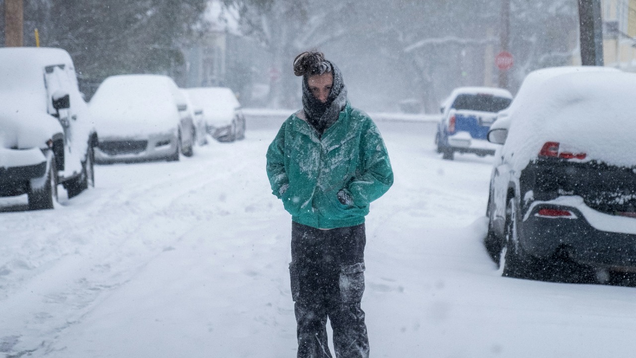
While much of the attention is on record warmth, the atmosphere is not delivering a quiet holiday for everyone. On the colder side of the pattern, winter storms on both coasts are already wreaking havoc for travelers, with heavy snow, strong winds and low visibility combining to snarl roadways and trigger flight cancellations. In the mountain pass area of Donner Summit, firefighters in Truckee extended a ladder to stranded residents at a house, a vivid example of how quickly conditions can deteriorate when Pacific moisture slams into cold air over high terrain.
Farther downstream, the same storm systems are tapping into deep moisture and dropping heavy rain, raising concerns about rivers and streams that are already running high. Forecasts warn that as these storms continue into the week, they could threaten record flood levels in some basins, particularly where snowmelt from earlier events adds to the runoff. The juxtaposition of stranded residents near Donner Summit and the risk of record flooding underscores how this winter pattern is not just about warmth but about volatility, with some communities facing dangerous snow and others bracing for high water as winter storms on both coasts collide with the broader pattern.
Travel, infrastructure and safety in a record‑threatening season
For travelers, the combination of record‑challenging warmth and intense storms creates a complicated and, at times, misleading picture. Mild temperatures can lull drivers into a false sense of security, encouraging longer trips or last‑minute departures, even as heavy rain, fog or high winds make highways treacherous. At the same time, those flying into or out of storm‑affected hubs must contend with cascading delays and cancellations, as airlines juggle aircraft and crews around snow‑choked runways in the West and weather‑disrupted airspace along the coasts. The disconnect between how the air feels at ground level and the hazards unfolding along the storm track is one of the defining risks of this pattern.
Infrastructure faces its own set of challenges in a season that swings between extremes. Rapid warmups can accelerate snowmelt and stress river levees, while saturated soils increase the odds of landslides and road washouts in hilly terrain. Urban drainage systems, already tested by intense downpours in recent years, must handle bursts of heavy rain that fall on ground that may still be partially frozen in some regions, a combination that can quickly overwhelm storm sewers and flood underpasses. As the Dec meteorologist and other forecasters emphasize, “getting ready” in this context means more than packing a lighter coat, it means recognizing that a rare winter pattern capable of shattering records also magnifies the stakes for travel safety, emergency response and the resilience of the systems that keep daily life running.
What this winter pattern signals about future extremes
Looking beyond the immediate holiday window, the emerging pattern offers a glimpse into how future winters may unfold in a warming climate that still supports sharp cold snaps. The fact that the U.S. just experienced its coldest winter in more than a decade, followed so quickly by a setup favoring record warmth around Christmas, illustrates how climate change can amplify both ends of the spectrum rather than simply erasing cold weather altogether. Warmer background temperatures load the dice toward higher records on the warm side, while shifts in jet stream behavior can still deliver intense, if shorter‑lived, Arctic outbreaks that feel every bit as harsh as those of past decades.
For communities, that means planning for winters that are less predictable and more prone to abrupt swings, with infrastructure and emergency systems that can handle both deep freezes and unseasonable thaws. Energy grids must be ready for surging demand during cold snaps and for the strain of warmer, stormier periods that bring high winds and heavy rain. Transportation networks, from interstates to rail lines and airports, need contingency plans that account for snow‑choked passes like Donner Summit one week and flooded lowlands the next. As I weigh the Dec meteorologist’s warning about an extremely rare winter pattern against the broader backdrop of recent seasons, the message is clear, record‑shattering events are becoming less of an outlier and more of a recurring test of how well we understand, and prepare for, the atmosphere’s capacity for surprise.
More from MorningOverview