On the flanks of Washington State Mount Rainier, a spike in seismic rumbling has revived an old, unsettling question for the Pacific Northwest: what happens when the region’s most dangerous volcano stirs within reach of a major metro area. Scientists are not saying an eruption is imminent, but they are clear that the system is restless and that an eruption is likely at some point in the future. For the millions who live and work in the shadow of this ice‑clad giant, the latest signals are a reminder that the clock on the next major event is still ticking.
Mount Rainier’s recent behavior is unfolding against a backdrop of heightened volcanic activity across the United States, from underwater peaks off the Oregon Coast to lava fountains in Hawaii. Taken together, these developments show how a chain of restless volcanoes intersects with dense population centers, critical infrastructure and fragile supply lines, turning geologic processes into a very human story of risk, preparation and political will.
Why Mount Rainier tops the US danger list
Mount Rainier has long been singled out by federal scientists as the most dangerous volcano in the country, not because it erupts more often than its peers, but because of where it sits and what surrounds it. The volcano towers over western Washington, its flanks draped in thick glaciers that can melt and collapse into fast‑moving lahars, volcanic mudflows capable of racing down river valleys and burying communities in minutes. Those valleys funnel directly toward the Puget Sound corridor, where suburbs, industrial hubs and transport arteries cluster around the broader Seattle–Tacoma region.
That combination of ice, steep slopes and downstream development is why hazard planners treat Rainier as a uniquely high‑consequence threat. Federal updates on Mount Rainier emphasize that even a moderate eruption could destabilize glaciers and trigger lahars that travel far beyond the mountain’s immediate slopes. The same agencies that monitor the volcano’s magma and gas also map evacuation routes, model mudflow paths and work with local governments to integrate those scenarios into land‑use and emergency plans, a level of attention that reflects Rainier’s place at the top of the national risk rankings.
The swarm that set off fresh alarm
Public anxiety spiked after reports that Washington State Mount Rainier had logged over 250 earthquakes in roughly a single day, one of the most intense swarms recorded there in years. For people who live in the lahar zones, the idea of hundreds of tiny quakes rattling beneath the ice‑capped summit sounded like the opening chapter of a disaster movie. Social media posts framed the swarm as proof that “something underground is shifting,” and the phrase quickly migrated into local conversations about whether the volcano was finally waking up.
Seismologists were quick to point out that swarms like this are not unusual at restless volcanoes, and that the key question is not how many quakes occur, but how their patterns evolve. Earlier in the year, specialists tracking the Cascades noted that the rate of Saturday the Mount Rainier earthquake swarms had already begun to decline after an earlier burst of activity, and that the strongest events appeared to be linked to preexisting faults beneath the volcano rather than clear magma movement. That context matters: a swarm can be a symptom of pressurizing magma, but it can also reflect the crust adjusting under long‑term tectonic stress, a distinction that shapes how urgently officials respond.
What the scientists are actually seeing
Inside the monitoring centers that watch the Cascades, the mood is more analytical than alarmist. Specialists at the regional observatory that oversees the range, including Mount Rainier, sift through streams of seismic, deformation and gas data to separate background noise from genuine unrest. Their public updates stress that the current signals, while elevated at times, remain within the envelope of behavior seen at other quiet but active volcanoes. That is why the official alert levels for the range have not been pushed to their highest settings, even as the public conversation has grown more urgent.
On a recent bulletin covering the broader CASCADE RANGE, the agency responsible for volcano alerts listed the current Volcano Alert Level and aviation color codes for multiple peaks, noting that activity across the chain remained within expected bounds for a restless but not erupting system. The notice, timestamped on a Friday morning in both PST and UTC, underscored that no Cascade volcano was in full eruption, even as some showed low‑level seismicity and gas emissions. That kind of language is calibrated: it acknowledges that the system is active without suggesting that people should expect ash in the air tomorrow.
Lessons from Mount St. Helens’ “ghost ash”
To understand how easily volcanic signals can be misread, it helps to look south to Mount St. Helens, where a strange ash haze earlier this year triggered a wave of speculation that the mountain was erupting again. Photos of gray skies and dusted cars ricocheted across feeds, and the memory of the catastrophic blast 45 years ago loomed over every rumor. Yet when scientists weighed in, they explained that the haze was not fresh magma at work, but older material being lofted back into the air by weather and climate shifts.
One detailed analysis noted that the ash cloud was “just stirring up leftover ash 45 years after ‘the big one,’” as By CNN Meteorologist, Briana Waxman, Updated Sep explained, and that seismic instruments around the volcano were still reading at normal, background levels. Another report, framed under the question “Where the ash around the mountain is coming from,” by Ginnie Sandoval of the Salem Statesman Journal, Updated Sept, walked through how wind patterns and lingering deposits can mimic the look of a fresh eruption. For Mount Rainier, the St. Helens episode is a cautionary tale: surface impressions can be dramatic, but the real story lies in the instruments.
How the Cascades are watched, minute by minute
Behind every calm or cautious statement about Rainier’s status is a dense web of sensors and specialists. The Cascades Volcano Observatory, part of the federal monitoring network, maintains seismometers, GPS stations and gas samplers on and around the major peaks, feeding data into models that track how magma and hydrothermal systems evolve. When the ground inflates, when gas ratios shift, when quake patterns change from scattered pops to rhythmic tremors, analysts at the observatory are the first to see it and to decide whether it signals a brewing eruption or routine background noise.
The observatory’s public portal for the Cascades Volcano Ob lays out how this surveillance works, from real‑time seismic feeds to hazard maps that show where lahars and pyroclastic flows are most likely to travel. For Mount Rainier, that means constant scrutiny of the glacier‑mantled summit and the valleys that drain it, as well as coordination with local emergency managers who would have to move people out of harm’s way. The same system keeps tabs on other Cascade peaks, ensuring that any shift in the broader volcanic arc is quickly folded into the risk picture for the Pacific Northwest.
Anchorage, Axial Seamount and a restless Pacific Rim
Rainier’s rumblings are part of a wider pattern of activity along the Pacific Rim that stretches from Alaska to Hawaii. To the north, the city of Anchorage sits within reach of multiple active volcanoes that rise from the Aleutian arc, a reminder that major urban centers and restless peaks often share the same geography. Farther south, an active underwater volcano off the Oregon Coast has become a case study in how precisely scientists can sometimes forecast eruptions, and how those forecasts intersect with coastal communities and offshore infrastructure.
Researchers tracking Axial Seamount, a submarine volcano on the Juan de Fuca Ridge in the Pacific Ocean, now predict that it will erupt in 2026, based on years of seafloor deformation and seismic data. One detailed report described how Axial Seamount, an active underwater volcano off the Oregon Coast in Oregon, has been inflating as magma accumulates beneath the seafloor. While a submarine eruption there would not send ash over cities the way a Cascade blast might, it could affect deep‑sea ecosystems, undersea cables and scientific observatories, underscoring how varied the impacts of volcanic activity can be even within a single region.
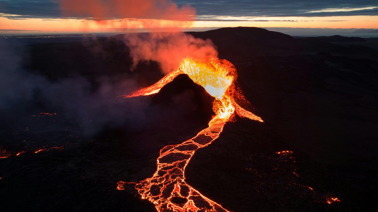
Hawaii’s lava, Rainier’s ice and the spectrum of eruption styles
At the other end of the spectrum from Rainier’s icy slopes is Kīlauea, where lava has been erupting episodically from the summit crater. In mid‑Dec, the volcano’s ongoing summit eruption in Hawaii’s Hawaiʻi Volcanoes National Park reached Episode 38, sending lava fountains and a plume soaring above 20,000 feet. Visitors watched from designated overlooks as molten rock arced into the air, a vivid display of volcanic power that, while hazardous near the vent, is relatively predictable compared with explosive, glacier‑capped systems like Rainier.
Scientists at the Hawaiian Volcano Observatory noted in a Dec update that Kīlauea has been erupting episodically since early in the month, and that “the forecast interval may change if the inflation rate varies,” a reminder that even well‑instrumented eruptions can shift as magma supply and pressure evolve. The bulletin on Dec activity also recalled how a south vent exploded earlier in the sequence, altering the eruption’s character. For Mount Rainier, the contrast is instructive: while Kīlauea’s lava flows are largely contained within a national park, Rainier’s hazards are dominated by water‑rich lahars and debris flows that can surge far downstream, turning a remote summit event into a lowland catastrophe.
How close is too close: cities in the shadow of giants
When people talk about Rainier as the country’s most dangerous volcano, they are really talking about proximity. The mountain looms over a corridor of suburbs, industrial zones and transport links that tie the Pacific Northwest into national and global supply chains. In that sense, it shares a family resemblance with other volcano‑city pairings, from Anchorage’s relationship with the Aleutian arc to the communities that ring the Cascades and Alaska’s interior peaks. The risk is not just ash in the air, but the cascading effects on aviation, shipping, energy and housing when a major eruption intersects with modern infrastructure.
Geography also shapes how people perceive and respond to that risk. For residents of towns built on ancient lahar deposits, the idea that their neighborhoods sit atop the debris of past disasters can feel abstract until a swarm of quakes or a plume of steam makes the hazard visible again. That is why detailed place‑based information, such as the mapping of Mount Rainier and its surrounding valleys, matters so much: it turns a distant summit into a concrete set of streets, schools and industrial parks that lie in potential flow paths. Similar mapping tools for the same volcano area help planners and residents visualize evacuation routes and shelter locations long before sirens ever sound.
From alerts to action: what preparedness really looks like
For all the attention on seismic swarms and alert levels, the most important work around Rainier happens in the quieter realm of planning and drills. Emergency managers use federal hazard maps to design evacuation zones, stage lahar sirens and run tabletop exercises that test how quickly schools, hospitals and businesses can move people out of harm’s way. They also work with communities to ensure that residents know whether they live in a lahar zone, where to go if an alert sounds and how to reunite with family if roads are cut or cell networks falter.
Those efforts are increasingly informed by detailed federal briefings on Mount Rainier and by the broader monitoring framework that covers the Cascades. They are also shaped by lessons from other volcanoes, including the way Kīlauea’s episodic eruptions have forced Hawaii’s authorities to refine their communication strategies, and how the Mount St. Helens ash scare showed the cost of misinformation. Even the way agencies describe Rainier’s geography, through tools that let users zoom in on the surrounding region, is part of that preparedness, turning abstract risk into something people can see on a map and plan around.
Living with a likely eruption
When scientists say that an eruption at Rainier is likely in the future, they are not predicting a specific day or even a specific decade. They are acknowledging that the volcano is part of an active arc, that it has erupted repeatedly in the geologic past and that its current behavior fits the profile of a system that will erupt again. For people in the region, the challenge is to translate that long‑term certainty and short‑term uncertainty into practical choices about where to build, how to insure and what to do when the next swarm or plume makes headlines.
In that sense, Rainier’s story is less about a single looming catastrophe and more about a permanent condition of life along the Pacific Rim. From Axial Seamount’s forecast eruption off the Oregon Coast to the episodic lava at Kīlauea and the ash ghosts of Mount St. Helens, the United States is threaded with reminders that its landscapes are still being built and rebuilt from below. The question is not whether the country can eliminate that risk, but whether it can stay honest about the stakes, invest in the science and infrastructure that make early warnings meaningful, and treat each new tremor as a prompt to refine, rather than panic about, the plans that will save lives when the mountain finally does more than stir.
More from MorningOverview