A set of mysterious grooves on a cave floor in France has turned out to be far more than abstract art. Archaeologists now argue that the engravings form the world’s oldest known three-dimensional map, a 13,000-year-old guide to a river valley that only fully reveals itself when water runs across the stone. The discovery not only rewrites the history of cartography, it also shows that Paleolithic people were already building interactive models of their landscapes long before paper maps or digital GPS.
By tracing how this ancient map was made, how it works and how it compares with later carved slabs from the Bronze Age, I can see a continuous thread of spatial thinking that stretches from Ice Age hunters to modern lidar surveys. The Ségognole 3 rock shelter, the Saint-Bélec slab and the latest digital scans all point to the same conclusion: humans have been turning terrain into touchable information for far longer, and with far more sophistication, than most of us imagined.
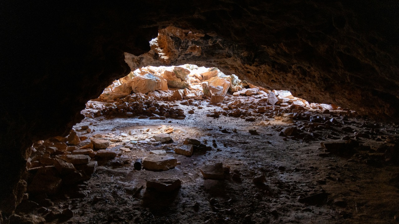
The cave floor that turned into a landscape model
The story begins in the Ségognole 3 cave in France’s École River Valley, where archaeologists had long known about enigmatic engravings cut into the floor. For years, these lines were catalogued as decorative or symbolic, part of the wider repertoire of Paleolithic art that includes animals and abstract signs. Only when researchers stepped back and looked at the full pattern did they realise that the grooves matched the contours of the surrounding valley, turning the cave floor into a miniature relief of the outside world that had been hiding in plain sight.
Researchers now argue that the engravings are not random, but a deliberate attempt to reproduce the topography of the École River Valley in three dimensions, with ridges, channels and basins corresponding to real hills and watercourses that would have been familiar to the people who lived there. The team behind the new interpretation describe how Researchers believe that engravings uncovered on the floor of the Ségognole 3 cave in France’s École River Valley may represent a sophisticated spatial model, revealing the mapping capabilities of early human societies.
A 13,000-year-old interactive 3D map
The age of the Ségognole 3 engravings is striking in its own right. Based on archaeological context and stylistic comparison, the team dates the work to approximately 13,000-years-ago, placing it near the end of the last Ice Age when hunter-gatherer groups were adapting to rapidly changing environments. That makes this 13,000-year-old carving the oldest known three-dimensional map, predating other contenders by several millennia and pushing the origins of 3D cartography deep into the Paleolithic.
What sets this map apart is not just its age but its interactivity. The study authors suggest that the map was modelled to reflect the region’s natural water flows and geomorphological features, and that its full effect emerges when water is poured or flows across the grooves, bringing the carved relief to life as channels fill and drain. One analysis notes that the map can be brought to life by water, which turns the static grooves into a dynamic simulation of streams and pools, a feature highlighted when Scientists Just Found the World‘s Oldest Map in a Cave, And It was described as interactive.
From sandstone shelter to quarzitic megaclast
The Ségognole 3 engravings sit within a broader cluster of discoveries that show how late Ice Age people used rock surfaces as three-dimensional canvases. In an ancient sandstone shelter, Researchers have uncovered what could be the world’s oldest three-dimensional map, etched into a quarzitic mega clast that forms part of the shelter wall. This massive block provided a stable, slightly curved surface that lent itself to carving relief features that mimic the surrounding terrain, turning geology into a natural screen for spatial information.
Reports describe how the 13,000-year-old, world’s oldest 3D map found in France shows advanced artistry, with the quarzitic mega clast covered in carefully planned incisions that align with local rivers and ridges. The object is described as the oldest example of its kind, a claim grounded in detailed comparison with later carved slabs and supported by the way the grooves track real-world features around the shelter. One account notes that the 13,000-year-old, world’s oldest 3D map found in France is located in a quarzitic mega clast in the sandstone shelter, underscoring how the natural rock was integral to the design.
How archaeologists proved it is really a map
Convincing the wider scientific community that a set of grooves is a map rather than abstract art requires more than a good story. The team working on Ségognole 3 and the sandstone shelter relied on a combination of high-resolution scanning, spatial analysis and comparison with modern topographic data to test their hypothesis. By digitally recording every incision and then overlaying the resulting 3D model on current maps of the École River Valley, they could show that key features, such as river bends and ridge lines, lined up far better than chance would allow.
This approach echoes the analysis used to interpret other ancient carved stones as maps. A recent study of the Saint-Bélec slab, for example, used detailed recording and statistical comparison to argue that the stone reproduces a real territory. That work, published in the Bulletin of the French Prehistoric Society, showed that the slab is a three-dimensional representation of a specific landscape, not a generic pattern. The same logic underpins the new cave interpretation, where the authors emphasise that their conclusions rest on systematic analysis rather than intuition, similar to the way a recent analysis in the Bulletin of the French Prehistoric Society demonstrated that a carved slab is a three-dimensional map of a territory in the world.
What the grooves reveal about water, movement and memory
Looking closely at the Ségognole 3 engravings, I see more than a static picture of hills and rivers. The emphasis on channels and basins suggests that water was central to how these mapmakers understood their world, and to how they chose to encode it. The carved lines trace the paths that streams take through the valley, the places where water pools and the routes that people and animals would follow along the banks. In a landscape where seasonal floods and shifting channels could make the difference between a successful hunt and a dangerous crossing, turning that knowledge into a shared, durable model would have been a powerful tool.
The interactive quality of the map reinforces this idea. When water is poured over the grooves, it follows the carved paths, dramatizing how rainfall or snowmelt would move through the valley and where it would collect. The study authors suggest that the map was modelled to reflect the region’s natural water flows and geomorphological features, which implies a deep understanding of hydrology long before formal science. One detailed report on the Ségognole 3 rock shelter notes that the study authors suggest that the map was modelled to reflect the region’s natural water flows and geomorphological features and that it dates to approximately 13,000-years-ago, a conclusion presented in oldest known three-dimensional map coverage.
Not a “map” in the modern sense, but something deeper
Even as archaeologists celebrate the Ségognole 3 engravings as the earliest known 3D map, some of the researchers involved are careful about the language they use. Dr. Milnes, who contributed to the study, has emphasised that this ancient representation is not a map in the modern sense of a scaled, north-oriented plan designed for precise navigation. Instead, it is a hybrid object that blends practical knowledge of routes and water sources with symbolic ideas about place, memory and perhaps even cosmology, reflecting a worldview in which landscape and story are inseparable.
I find that distinction important because it prevents us from projecting our own cartographic habits onto people who lived 13,000-years-ago. Rather than treating the cave floor like an early version of a road atlas, it may be more accurate to see it as a shared reference point where a group could gather to discuss journeys, hunting grounds or seasonal movements, using the grooves as prompts for oral explanations. One account of the research notes that Dr. Milnes stressed that this ancient representation is not a “map” in the modern sense, a point made in a discussion of how Dr. Milnes sees such carvings as part of a broader category dedicated to lidar archaeology and the ways past societies engaged with their environment.
The Saint-Bélec slab and the Bronze Age mapping tradition
The Ségognole 3 discovery does not stand alone. In western Brittany, a carved stone known as the Saint-Bélec slab (Breton: Taol Sant-Beleg) has already transformed how archaeologists think about early maps. The Saint-Bélec slab is a stone artefact from Brittany thought to be a map of a local territory, with raised areas and incised lines corresponding to hills, rivers and boundaries. It was made during the Bronze Age, long after the Paleolithic engravings, but it shows that the idea of turning landscapes into three-dimensional diagrams persisted and evolved.
The slab was first discovered in Brittany in 1900, then forgotten in a cellar until it was rediscovered and reanalysed using modern techniques. After analysing marks and engravings, researchers concluded that the piece of rock, known as the Saint-Bélec Slab, is believed to date to the Bronze Age and that it could be a map of a political territory, perhaps linked to the authority of a local ruler. One report explains that the slab was first discovered in Brittany in 1900 and that the piece of rock, known as the Saint-Bélec Slab, is believed to date to the Bronze Age and that it could be a map, a conclusion that helped establish it as the oldest 3D map in Bronze Age Europe.
From forgotten cellar stone to political map
The modern story of the Saint-Bélec slab underlines how easily evidence of early mapping can be overlooked. After its initial discovery, the stone spent decades out of sight, stored in a cellar where its significance went unrecognised. Only when archaeologists returned to it with fresh questions and better tools did they realise that the patterns of lines and depressions were not random decoration but a coherent plan of a real landscape, complete with boundaries that may mark the extent of a chiefdom or estate.
Detailed study has shown that the slab was made during the Bronze Age and later reused as part of a burial, suggesting that its political meaning may have shifted over time. One account notes that The Saint-Bélec slab (Breton: Taol Sant-Beleg) is a stone artefact from western Brittany thought to be a map, and that The Saint-Bélec slab was made during the Bronze Age and then broken and reused, perhaps as a symbolic act marking the end of the previous political entity, a narrative summarised in the entry on The Saint slab from Brittany.
Why this Paleolithic map changes the history of cartography
When I place the Ségognole 3 engravings alongside the Saint-Bélec slab, a clear pattern emerges. The Bronze Age stone shows that by that time, elites were using carved maps to assert control over territories, while the Paleolithic cave floor suggests that much earlier communities were already capable of abstracting their surroundings into three-dimensional models. The new discovery therefore pushes the roots of cartographic thinking far deeper than the Bronze Age, showing that the cognitive skills needed to build maps were present in hunter-gatherer societies that left no written records.
This shift matters for how historians and archaeologists write the story of maps. Instead of starting with clay tablets or medieval portolan charts, the narrative now has to account for Ice Age engravers who could translate hills and rivers into lines and ridges on stone, and who may have used those models to coordinate movement, share knowledge and negotiate access to resources. One overview of early mapping traditions notes that a recent analysis, published in the Bulletin of the French Prehistoric Society, has shown that a carved slab is a three-dimensional representation of a territory in the world, a finding that, when combined with the Ségognole 3 evidence, forces a rethinking of early world maps and the deep history of spatial representation.
Digital tools meet Ice Age design
Ironically, it has taken some of the most advanced mapping technologies of the twenty-first century to reveal the sophistication of these Stone Age maps. High resolution 3D scanning, photogrammetry and lidar have allowed researchers to capture every millimetre of the cave floor and carved slabs, then manipulate the data to test how well the engravings match real terrain. By simulating water flow across the digital models, they can also explore how the interactive aspects of the Ségognole 3 map would have worked in practice, something that would be impossible to see clearly in the dim light of a cave.
These tools are not just technical add-ons, they are central to the argument that the engravings are intentional maps rather than coincidental patterns. In the sandstone shelter case, for example, the team used detailed scanning to show that the quarzitic mega clast carries a coherent three-dimensional representation of the surrounding landscape, supporting the claim that it is the world’s oldest three-dimensional map. One report on this work describes how Researchers have uncovered what could be the world’s oldest three-dimensional map, etched into a quarzitic mega clast in an ancient sandstone shelter, a finding presented under the heading World’s Oldest 3D Map discovered in an ancient sandstone shelter.
How far back could 3D mapping really go?
The Ségognole 3 discovery currently holds the title of the oldest known three-dimensional map, but it almost certainly will not be the last. Once archaeologists start looking at engraved stones and cave floors with mapping in mind, other candidates are likely to emerge, especially in regions where hunter-gatherers relied on complex river systems or coastlines. The key will be applying the same rigorous combination of fieldwork, digital recording and spatial comparison that has been used in France, rather than assuming that any abstract pattern is purely symbolic.
At the same time, I think it is important to recognise the limits of what the evidence can show. Not every set of grooves will turn out to be a map, and there is always a risk of seeing patterns where none were intended. That is why the Ségognole 3 case is so compelling: the engravings align with real topography, they highlight water flows in ways that make functional sense, and they fit within a broader tradition of carved landscape models that includes the Saint-Bélec slab and other Bronze Age stones. One widely cited account of the French discoveries notes that a freshly unearthed Bronze Age slab found in France is the oldest 3D map in Europe and that after analysing marks and engravings, one of the study’s authors told the BBC that the piece of rock is believed to date to the Bronze Age and that it could be a map, a reminder, in the context of The slab, of how careful analysis can turn a carved stone into a recognised map.
More from MorningOverview