Far off the rocky tip of Brittany, a stone barrier nearly the length of a football field has emerged from the Atlantic, not by receding tides but through sonar scans and diver surveys. The 7,000-year-old underwater wall appears to be part of a vanished Stone Age landscape, and its scale suggests it may rank among the largest prehistoric structures ever identified on a European seabed. As researchers piece together how and why it was built, the discovery is reshaping what I thought I knew about early engineering in Atlantic Europe.
The wall’s age places it thousands of years before written records in the region, at a time when sea levels were lower and the coast of what is now France looked radically different. Yet the structure’s deliberate layout, its association with other submerged features, and its survival beneath shifting sands all point to a community that invested serious labor and planning into reshaping its environment.
The wall that surfaced from the seafloor
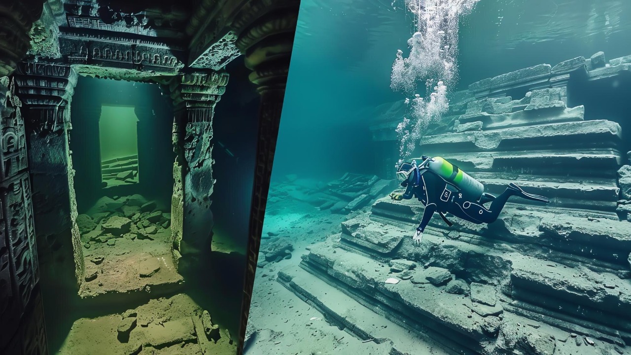
The newly documented structure lies off the coast of Brittany, near the far western tip of France, where strong currents and shallow banks have long challenged sailors. Marine archaeologists first noticed an unusual linear feature while surveying the seabed, then confirmed through dives that it was a continuous stone barrier, not a random scatter of boulders. Early reports describe a nearly 400-foot-long alignment of granite blocks, carefully stacked and interlocked, that now rests about 30 feet below the surface in waters off the Ile de Sein and the surrounding shoals of Brittany.
Researchers estimate that the wall dates back roughly 7,000 years, placing its construction around 5800 BCE, when this part of the continental shelf was still dry land. The structure has been described as a 400-foot-long granite formation that retains a consistent height and orientation, which strongly suggests deliberate human design rather than natural deposition. Its discovery came as part of a broader effort to map submerged Stone Age landscapes, and the team has linked the feature to a cluster of other manmade elements, including smaller walls and possible enclosures, that extend across the now-flooded plain off western France.
How divers and lasers found a Stone Age giant
The wall did not reveal itself to chance snorkelers. It emerged from a combination of high-resolution seabed mapping and targeted diving, a method that has become standard in underwater archaeology. A French geologist working along the Brittany coast noticed a straight, raised line on bathymetric data that cut across the natural contours of the seafloor. That anomaly prompted a closer look using remote laser and sonar techniques, which confirmed a continuous ridge about 30 feet down that did not match the surrounding geology. Only after this digital groundwork did divers descend to inspect the stones directly and document their arrangement.
Once in the water, the dive team reported a massive 7,000-year-old undersea wall that ran in a remarkably straight course, with stones placed in a way that resisted the Atlantic’s powerful swells. According to accounts of the survey, the structure was found alongside a dozen smaller manmade features, some of which appear to form pens or funnels that could have guided animals. The divers’ observations, combined with morpho-tectonic analysis of LIDAR and sonar data, have been shared with specialists who study submerged prehistoric landscapes, and the find is now being discussed in connection with broader research on ancient coastal settlements in the International Journal of Nautical Archaeology.
Measuring up: length, age, and engineering
In raw dimensions, the wall is impressive. Reports describe it as nearly 400 feet long, or about 120 meters, which makes it comparable in length to a modern soccer pitch and far larger than most known Mesolithic or early Neolithic structures preserved underwater. One analysis refers to a submerged wall measuring approximately 120-meter in length, emphasizing that it is one of the oldest prehistoric constructions yet documented on a seabed. The stones are granite, a hard local rock that would have required significant effort to quarry, move, and stack into a stable barrier that could withstand coastal weather even before the sea advanced.
Dating a structure like this is not straightforward, since the granite itself cannot be radiocarbon dated. Instead, archaeologists rely on associated sediments, sea-level reconstructions, and any organic material trapped around the base of the stones. Multiple lines of evidence converge on an age of about 7,000 years, which aligns with a period when the shoreline lay several kilometers seaward of its present position. That timing is consistent with other underwater features in the area, including additional 7,000-year-old walls discovered off the French coast that appear to be part of the same drowned landscape. Together, these metrics support the claim that this is not only a very old structure but potentially one of the largest early Holocene walls yet identified beneath European waters.
A vanished coastline and a sunken city
To understand why anyone would build such a wall, I have to picture the region as it looked before the sea rose. At the time of construction, the area now covered by waves would have been a low-lying coastal plain, with marshes, tidal channels, and perhaps small islands connected by dry ground. Archaeologists have found evidence of a 7,000-Year-Old Sunken City in the same general zone, suggesting that entire settlements once stood where fishing boats now pass. These communities would have had access to rich marine resources, fertile soils, and strategic vantage points along what was then the Atlantic fringe of Europe.
As global sea levels climbed after the last Ice Age, this landscape was gradually inundated, turning fields and villages into what some researchers now call a prehistoric Atlantis. One report even describes a huge 7000-year-old undersea wall found in a sunken Stone Age city which “inspired Atlantis myth,” noting that FRENCH marine archaeologists uncovered the feature near the far western tip of France. While direct links to any specific legend remain speculative and unverified based on available sources, the idea of a once-thriving coastal community swallowed by the ocean is no longer fantasy. It is a working hypothesis grounded in sonar maps, diver logs, and the stonework that still stands on the seabed.
Hunting wall or territorial line? Competing theories
Archaeologists are now debating what purpose the wall served, and two main hypotheses have emerged. The first sees it as a sophisticated hunting device, a kind of funnel or drive line used to corral animals. In this view, the barrier would have guided herds of wild game, perhaps red deer or aurochs, toward natural bottlenecks, pits, or waiting hunters. The presence of a dozen smaller manmade structures near the main wall, some arranged in arcs or enclosures, supports the idea of a complex designed to manipulate animal movement. One study notes that the structures likely formed part of a system that extended a few miles to the east, suggesting a large-scale landscape modification rather than an isolated feature.
The second hypothesis interprets the wall as a boundary marker, either between groups or between different zones of land use. Some researchers have suggested that the 7,000-year-old underwater wall found off the French coast may have functioned as a territorial line, a property boundary, or even a symbolic demarcation between communities. This idea gains traction from comparisons with later Neolithic field systems and megalithic alignments, which often served social as well as practical roles. A related analysis of a submerged wall approximately 120 meters long and over 7 years old (a phrasing that clearly intends to convey a much greater antiquity) notes that archaeologists are working with two main hypotheses about the structure’s purpose, echoing the same split between hunting infrastructure and boundary marker.
Rewriting the timeline of European megaliths
Whatever its function, the wall’s age has major implications for the history of large-scale stone construction in Europe. For years, many scholars placed the emergence of megalithic architecture, such as stone circles and long barrows, in the later Neolithic, after farming communities became established. The new underwater evidence suggests that people along the Atlantic seaboard were moving and arranging heavy stones centuries earlier than previously thought. One assessment explicitly frames the find as a 7000-Year-Old Sunken Discovery Points to European Megalithic Construction Centuries Earlier Than Previously Thought, arguing that the wall predates classic monuments yet shows comparable ambition in its engineering.
This shift in timing matters because it challenges the assumption that only settled farmers had the social organization and surplus labor to build large stone works. The communities that raised this wall may have been hunter-gatherers, or groups in transition toward early agriculture, yet they still coordinated the transport and placement of hundreds of granite blocks. Another report on a Prehistoric Underwater Wall Hints at Sophisticated Human Engineering 7,000 Years Ago, describing a 400-foot-long structure, reinforces the idea that complex construction projects were already underway long before the better-known megaliths of Brittany and the British Isles. The wall, in other words, pushes back the clock on when Europeans first began to reshape their landscapes with stone on a monumental scale.
From routine missions to record-breaking finds
The discovery also highlights how much of prehistory still lies hidden in unexpected places, sometimes revealed by activities that have nothing to do with archaeology. One account describes How a Routine Mission Led to a Rare Find, noting that a French Army operation, not typically associated with archaeological sites, helped uncover a record-breaking feature. In that case, survey work carried out for defense or navigation purposes produced data that, once examined by specialists, revealed traces of ancient human activity on the seabed. The same pattern appears in the Brittany wall, where mapping for coastal management and hazard assessment provided the baseline imagery that archaeologists later reinterpreted as evidence of a human-made structure.
Public interest in such finds can be intense, and sometimes it intersects with broader political or economic narratives. The same report that details the routine mission and rare find also mentions that it is Officially Confirmed that Americans will soon get “very large refunds” of a kind not typically associated with archaeological sites, a reminder of how online stories can blend disparate topics to capture attention. For researchers, the challenge is to separate the sensational from the substantive, focusing on the hard data from sonar, LIDAR, and diver observations while acknowledging that dramatic phrases like “record-breaking” or “Atlantis” help bring much-needed visibility and funding to underwater heritage work.
Science in public: from journals to Reddit threads
As news of the wall spread, discussion quickly moved beyond academic circles into online communities. A post titled Ancient undersea wall dating to 5800 BCE appeared on a science forum, where users highlighted the morpho-tectonic analysis of LIDAR that helped identify the feature and debated the implications for early coastal settlement. The thread, shared by a user named Hrmbee, included comments that began with “Please” and “Some” as participants asked for more data, questioned the dating methods, and compared the find to other submerged landscapes like Doggerland in the North Sea. This kind of informal peer review, while not a substitute for formal publication, shows how rapidly new discoveries are now scrutinized and contextualized by a global audience.
At the same time, more traditional outlets have emphasized the role of professional divers and marine archaeologists in verifying the structure. One detailed report notes that Divers discover massive 7,000-year-old undersea wall off coast of France, describing how the team documented the stones, measured their alignment, and linked the feature to a broader pattern of submerged structures that will be analyzed in the Journal of Nautical Archaeology (2025). Another account of divers who discover 7,000-year-old undersea wall off coast of France stresses that the nearly 400-foot-long wall was found off the Ile de Sein in Brittany, along with a dozen smaller manmade structures from the same period, and quotes researchers who say it is likely the oldest such find in the region. Together, these channels, from Reddit threads to peer-reviewed journals, are shaping how the public and the scientific community understand the wall’s significance.
What the wall reveals about early coastal life
Beyond its engineering, the wall offers a rare window into how people lived along the Atlantic coast 7,000 years ago. Evidence from the broader region indicates that societies were transitioning from mobile foraging to more settled Neolithic communities, with mixed economies that combined hunting, gathering, and early farming. One synthesis notes that Archaeologists Found Evidence of a 7,000-Year-Old Sunken City and promises that readers will learn how societies transitioned to Neolithic settlements, underscoring that the drowned landscape off Brittany was not just a hunting ground but a place where people built homes, managed herds, and perhaps cultivated crops. The wall, whether used for driving game or marking fields, fits into this picture of increasing territoriality and investment in specific places.
Other underwater structures off the French coast reinforce this interpretation. A survey that describes 7,000-year-old walls discovered off French coast emphasizes that these feats of engineering are unique in their scale and arrangement, suggesting a community that understood both the opportunities and risks of living close to the sea. Another analysis of a human-made wall beneath the waves notes that the seabed was once dry land, and that direct dating cannot be used on the stone itself, but the surrounding context points to a time when people were adapting to rising waters. In that sense, the wall is not just a relic of the past but a case study in how human societies respond to environmental change, a theme that resonates strongly today.
Why this submerged giant matters now
For me, the most striking aspect of the 7,000-year-old underwater wall is how it compresses so many themes into a single line of stone: technological ingenuity, environmental upheaval, social organization, and the fragility of coastal life. It stands as a reminder that long before modern sea walls and climate adaptation plans, people along the Atlantic fringe were already grappling with shifting shorelines and trying to shape their surroundings to survive. The fact that such a massive structure could vanish beneath the waves and remain hidden until remote sensing and careful diving brought it back into view speaks to how incomplete our picture of prehistory still is.
As researchers continue to analyze the wall and its neighboring features, I expect more surprises. The structure that this latest discovery revealed dates back about 7,000 years, and early interpretations suggest it may be one of the largest ever found on a seabed, whether as a hunting device, a boundary line, or a territorial marker. Future work will likely refine its age, map its full extent, and perhaps uncover associated artifacts that can tell us more about the people who built it. For now, the wall off Brittany joins a growing list of submerged sites that are forcing archaeologists to redraw maps of early Europe, and it underscores how much of human history still lies just out of sight, beneath the surface of the sea.
More from MorningOverview