Ocean heat is quietly rewriting the rules of the planet’s most dangerous storms, loading hurricanes with more fuel than the current scale was ever designed to capture. As those waters warm, a growing group of researchers now argues that the world is edging into an era where a “Category 6” label may be the only honest way to describe the most extreme cyclones.
The debate is not about semantics so much as survival: if the atmosphere keeps absorbing heat from record‑warm seas, the ceiling on hurricane intensity rises, and with it the risk of damage that outstrips today’s planning assumptions. I see the emerging science as a warning that coastal societies are underestimating both the power of future storms and the speed at which they can form.
Why hotter oceans are turbocharging hurricanes
To understand why scientists are even talking about a Category 6, it helps to start with the physics. Tropical cyclones are heat engines that run on warm, moist air, drawing energy from the ocean surface and converting it into ferocious winds and rain. Classic hurricane “anatomy” research notes that one of the first conditions for formation is sea water above 26 degrees Celsius, or 79 degrees Fahrenheit, and that storms tend to weaken over water Below this threshold. As climate change pushes more of the world’s oceans above that line for longer stretches of the year, the “fuel tank” for hurricanes is effectively expanding.
Warmer seas do not just flip storms on, they also crank them up. As sea surface temperatures rise, the ocean transfers more latent heat into the atmosphere, which allows winds to strengthen and pressures to fall more quickly. An in‑depth explainer on hotter oceans notes that the warmer the ocean water is, the more energy a storm can accumulate and the more rapidly it can intensify once winds exceed 74 miles per hour. A separate chapter that is Source material, Adapted from IMO, underscores that Climate change is altering tropical cyclone formation in two key ways: by increasing the amount of warm, moist air available and by shifting the regions where storms that use warm, moist air as fuel can form.
The Saffir‑Simpson ceiling and the Category 6 proposal
The current Saffir‑Simpson scale tops out at Category 5, which covers any storm with sustained winds of at least 157 miles per hour, whether it barely clears that bar or far exceeds it. That made sense in an era when such extremes were rare, but as the planet warms, some storms are now so intense that they cluster at the very top of the scale with little distinction. A detailed analysis of recent storms notes that Feb research has identified multiple hurricanes since 2013 whose winds significantly surpassed the minimum Category 5 threshold, raising questions about whether the scale still communicates risk effectively.
That is where the Category 6 idea comes in. A group of scientists has suggested carving out a new top tier for storms with sustained winds above roughly 192 miles per hour, a level that would capture only the most extreme cyclones on record. In a Warming World analysis, researchers in a piece titled Climate Scientists Consider Category 6 Hurricanes explain that such a category would apply to storms with wind speeds greater than 192 mph, and the piece is By Linda Vu, who highlights how Hurricane Hurricane Patrici helped crystallize the debate.
Evidence that storms are already pushing past Category 5
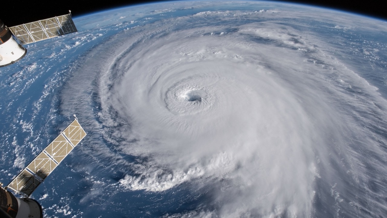
Scientists are not speculating in a vacuum; they are looking at a data set that shows the upper tail of hurricane intensity thickening. One global review of satellite and best‑track records finds that Earth is witnessing a rise in the number of storms that would be ranked as Category 5, a trend that aligns with basic thermodynamics as oceans warm. That same research points to Hurricane Patricia of 2015, described in another Stronger analysis as an example of a storm whose peak winds were so high that it would fit neatly into a hypothetical new Category 6, and the report even invites readers to View a larger image of Hurricane Patricia of 2015 to appreciate its structure.
Other researchers have tried to quantify just how rare such monsters are. One study of historical records concluded that, Of the Of the 197 hurricanes classified as Category 5 from 1980 to 2021, only a handful, including storms like Typhoon Haiyan and Typhoon Surigae, would meet the criteria for a hypothetical new Category 6. That tiny fraction is precisely why some experts argue that a new label would not be used lightly, but would instead flag only the most catastrophic events that demand extraordinary preparation.
Ocean “hotspots” and the spread of mega‑hurricane fuel
Behind the statistics is a more unsettling geographic shift: the regions of the ocean capable of powering these mega‑storms are spreading. New modeling work shows that the “thermal reservoirs” needed to sustain the most intense cyclones are expanding across the tropics and subtropics, creating more patches of water deep and warm enough to keep a storm at peak strength. A detailed feature on the emerging “era of the mega‑hurricane” describes how Dec research has found that these ocean hotspots have spread rapidly in just the last decade, a harrowing sign that the background conditions for extreme storms are becoming more common.
More granular work from climate scientists backs up that picture. A recent analysis of “Category 6” tropical cyclone hot spots concludes that Burgeoning ocean hotspots feed big storms, and that the area of the Atlantic and western Pacific with waters warm and deep enough to support such extremes has grown as well, according to work led by Lin and colleagues. Another global overview of these hot spots notes that this process, driven by climate change, is increasing the risk of “Category” 6 tropical cyclones making landfall in densely populated regions, with one report warning that such hotspots capable of driving catastrophic mega‑hurricanes are rapidly expanding across the oceans Dec.
How scientists define a hypothetical Category 6
Even among experts who agree that storms are getting stronger, there is debate over where to draw the line for a new category. The most widely cited proposal would keep Category 5 as it is and introduce Category 6 for storms with sustained winds above about 192 miles per hour, a threshold chosen because it captures only a few historical outliers. A detailed science explainer asks, How strong such a storm would be and explains that a new Category 6 would apply to hurricanes with maximum sustained winds above that 192 mph mark, with the authors warning that the frequency of such storms is expected to increase with climate change.
Other researchers are exploring whether the entire rating system needs an overhaul rather than a simple add‑on. One proposed framework would move away from a wind‑only scale and instead rate storms based on multiple hazards, including rainfall, storm surge, and wind, with the possibility of adding a Category 6 when any two threats are extreme. A detailed breakdown of this idea explains that a Sep proposal for a new system suggests that a Category 6 Hurricane label could be triggered when any two of those hazards reach the highest level, reflecting the reality that flooding and surge often kill more people than wind alone.
The scientific debate: scale change or public‑awareness tool?
Not all scientists are convinced that the Saffir‑Simpson scale should be rewritten, even if they agree that storms are intensifying. Some argue that adding a Category 6 could create confusion or complacency, with people in the path of a “mere” Category 4 underestimating the danger. A nuanced overview of the debate notes that the scientists behind the new research are not necessarily saying the scale should change, and that, according to a Feb summary, they see their work more as a way to spur academic discussion and public awareness, as one researcher told the Washington Post when describing the findings.
Others counter that the language we use to describe risk matters, especially as climate change reshapes the extremes. A televised segment titled Feb “In Depth with Dan” asks whether we need a Category 6 for hurricanes and walks viewers through how “climate boosted” storms are pushing scientists to rethink classifications. Another analysis of the broader trend notes that Greater awareness of climate change is driving interest in how hurricane categories might need to evolve, with researchers warning that the strongest storms are expected to increase under climate change and that public communication must keep pace.
Real‑world storms that look like Category 6 prototypes
For coastal residents, the Category 6 debate becomes tangible when they see storms that already seem to fit the description. Super Typhoon Haiyan, which devastated parts of the Philippines, is often cited as a prototype, with satellite imagery showing a near‑perfect, tightly wound eye and extraordinarily cold cloud tops. A detailed look at the growth of hot spots notes that Satellite images of Super Typhoon Haiyan at maximum intensity illustrate just how extreme these storms can become, and the same report, titled Hotspots for Category 6 storms are growing, links that visual evidence to the expanding ocean hot spots beneath.
More recently, Atlantic storms like Hurricane Beryl have reignited the conversation. When Beryl rapidly intensified over exceptionally warm Caribbean waters, some researchers pointed to it as an example of how quickly storms can now jump categories. A detailed piece on that storm asks, Why some scientists are proposing a new Category and quotes climate scientist Michael Wehner of the Lawrence Berkeley National Laboratory and co‑author James on how a revised scale might better capture that behavior.
Climate change, frequency, and the risk of catastrophic damage
One nuance that often gets lost in public debate is that climate change may not increase the total number of hurricanes, but it is likely to shift their intensity profile. Several modeling studies suggest that while overall storm counts could stay the same or even decline, the share of storms that reach the highest categories will grow. A concise summary of this research notes that Hurricanes may become less frequent but more intense, and that the most powerful storms are more likely to do catastrophic damage, a pattern that is already prompting debate on whether a new Category is needed.
That shift has profound implications for coastal infrastructure and insurance systems that were designed around historical risk. A detailed climate science feature explains that Hurricanes are getting stronger because the warmth of the air and the oceans drives hurricanes, and both Earth’s atmosphere and seas are warming, with the strongest storms expected to increase under climate change. Another in‑depth report on how Home planet Earth is changing warns that Oceans Are Supercharging Hurricanes, and that scientists warn “Scientists Warn” Category 6 storms are becoming more likely as these storm‑forming hot spots proliferate.
Public communication, preparedness, and what comes next
For emergency managers and coastal residents, the Category 6 conversation is ultimately about clarity. If the scale does not keep up with the physics, there is a risk that people will misjudge the danger of the most extreme storms, especially as rapid intensification becomes more common. A widely discussed study on the topic, summarized in a national news report, notes that Feb research on a potential new Category finds that Scientists, including Kossin, have occasionally raised the idea precisely to better communicate the upper‑end risk to the public.
At the same time, some experts caution that focusing too much on a hypothetical new label could distract from more immediate steps, like improving building codes, evacuation planning, and flood defenses for storms of all categories. A broader climate‑risk overview notes that Liz Ritchie and Tyo emphasize that even without a formal Category 6, communities must prepare for hurricanes that are less frequent but more intense, and that the storms most likely to do catastrophic damage are already here. As I read the emerging science, the message is blunt: whether or not the scale changes, warming oceans are rewriting the upper limits of hurricane power, and coastal societies have little time to catch up.
More from MorningOverview