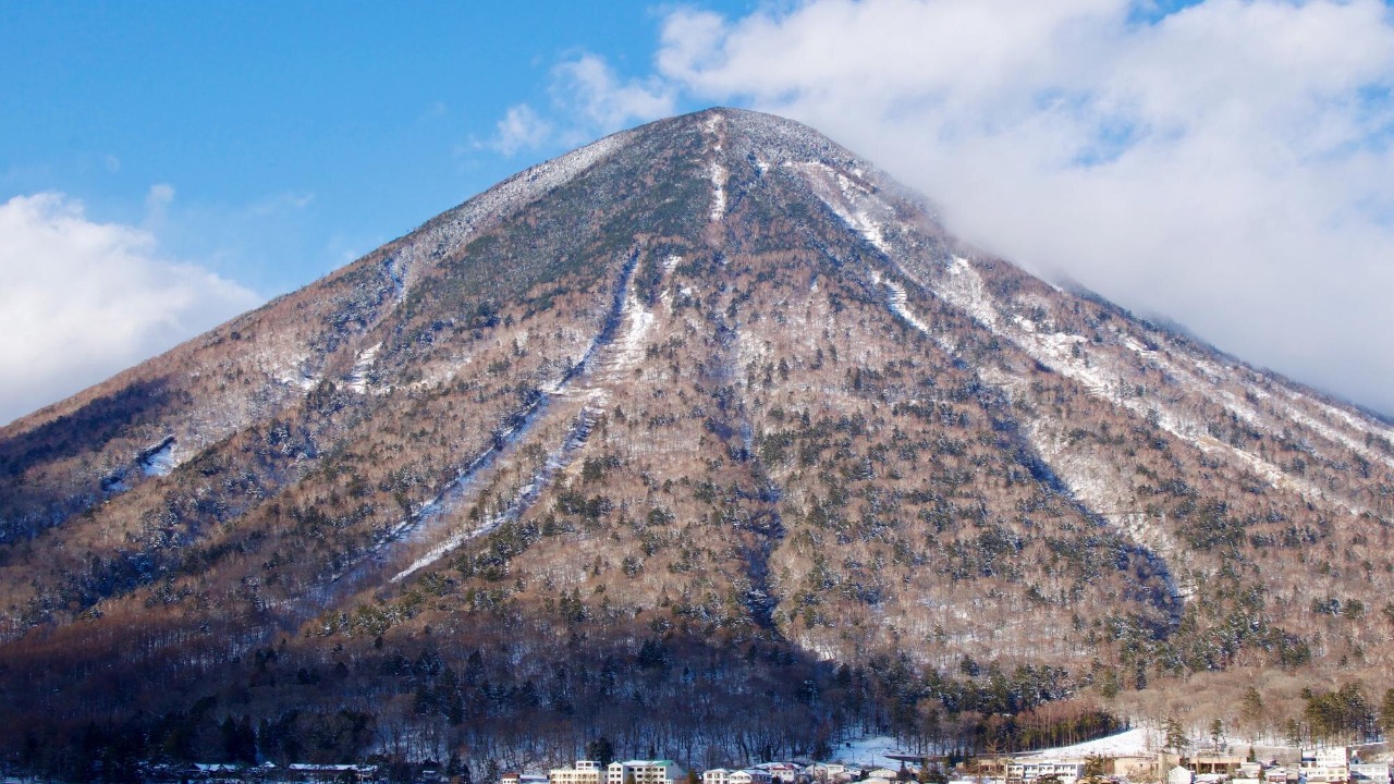
Mount Rainier’s quiet, snowcapped profile hides a restless interior that has just rattled itself with more than a thousand tiny earthquakes, a reminder that one of the country’s most dangerous volcanoes sits within striking distance of the Seattle–Tacoma metro area. For the roughly 300,000 people who live, work, or commute through the river valleys draining its flanks, the real risk is not fire and ash but fast-moving mudflows that could race down those channels with little warning. The latest swarm has reignited questions about what is happening beneath the mountain, how worried residents should be, and whether the region is truly prepared for the worst-case scenario.
Scientists tracking the swarm say the quakes are small and shallow, and so far they see no sign that magma is on the move toward the surface. Yet the sheer number of events, layered on top of Mount Rainier’s history of catastrophic landslides and lahars, is enough to test public nerves and fuel viral rumors. I want to unpack what the data actually show, why experts are stressing calm rather than panic, and how a hazard that could affect hundreds of thousands of people is being monitored in real time.
Rainier’s restless summer: from swarm to “typical” again
The story of this year’s seismic burst at Mount Rainier begins with a cluster of small quakes that lit up monitoring screens earlier in the summer and then kept going. Instruments recorded a swarm of low magnitude events beneath the volcano, with activity peaking in early July and continuing into late August as the mountain shuddered more than 1,000 times in a matter of weeks. The pattern fit what volcanologists describe as a classic swarm, a flurry of earthquakes in a confined area that can reflect changes in fluids or stress within the crust rather than a single large fault rupture.
By late Aug, federal scientists reported that Earthquake activity at Mount Rainier had eased back to what they consider typical background levels, even as they continued to review the data. A separate notice for MOUNT RAINIER highlighted that the swarm, which included events up to magnitude 2.42, had been closely tracked and that key parameters like deformation and gas output remained stable. Those bulletins, issued on a Monday afternoon in local PDT and cross referenced in UTC, underscored a central point: the mountain had been noisy, but the broader system did not show the hallmarks of an impending eruption.
What a 1,350-quake swarm really means
Raw numbers can be alarming, and the figure that grabbed attention this year was the tally of roughly 1,000 to 1,350 earthquakes beneath the volcano. For a layperson, that sounds like a drumroll to disaster. For seismologists, the more important questions are how big those quakes are, how deep they occur, and whether they are changing over time. In this case, the swarm was dominated by tiny events, many too small for people at the surface to feel, clustered beneath the summit and upper flanks where the volcano’s hydrothermal system circulates hot water and gas.
Researchers later detailed that 1,350 earthquakes were logged during the episode, a count that puts the swarm among the more active periods in Rainier’s modern monitoring record. Yet the same analysis emphasized that the seismicity fit within the range of behavior seen at other active volcanoes and that the pattern, while busy, did not show the escalating energy or deep-to-shallow migration that would suggest magma forcing its way upward. In other words, the number is striking, but the character of those 1,350 events matters more than the headline figure.
Inside the swarm: small, shallow, and closely watched
To understand what was happening beneath the ice, scientists leaned on a dense network of seismometers and other instruments that ring the volcano. Those monitoring stations picked up a swarm of small magnitude earthquakes centered beneath the edifice, with many events occurring at shallow depths where hot fluids circulate through fractured rock. The pattern resembled previous swarms recorded at Rainier, including one in 2009, suggesting that the mountain was repeating a familiar internal adjustment rather than entering a new, more dangerous phase.
In a technical update, the Cascades Volcano Observatory described how monitoring stations detect small magnitude earthquakes at Mount Rainier and use them to map out the volcano’s shallow plumbing. The note, labeled “By Cascades Volcano Obs,” explained that the swarm, which ramped up in Jul and included a magnitude 2.42 event on July 11, was consistent with movement of fluids in the volcano’s hydrothermal system. That interpretation was echoed in other coverage that described how hundreds of small earthquakes rattle Mount Rainier in a way that resembles earlier swarms, with magnitudes and depths that fit a noneruptive pattern.
Officials say “no cause for concern,” and why that matters
As the swarm unfolded, the agencies responsible for tracking the volcano moved quickly to frame the risk in plain language. They stressed that while the number of quakes was elevated, the behavior did not match the kind of accelerating unrest that would prompt an alert level change or evacuations. That message was aimed not only at scientists and emergency managers but also at hikers, climbers, and residents who might see the raw seismic data online and assume the worst.
In one widely cited briefing, Officials tracking an earthquake swarm at Mount Rainier said there was “no cause for concern,” explaining that the quakes were small, that there was no sign of magma rising toward the surface, and that other indicators like ground deformation and gas emissions remained steady. The same message surfaced in local coverage that noted how, Despite the flurry of activity, scientists saw no abnormal sounds or other warning signs in their sensors. That kind of consistent, measured communication is crucial in a region where the stakes are high and the margin for misinterpretation is thin.
What gas sampling reveals about the volcano’s plumbing
Seismometers are only part of the toolkit that scientists use to interpret a swarm like this. To probe what was driving the quakes, researchers turned to airborne and ground-based gas measurements, essentially sniffing the volcano’s breath for clues. If magma were rising or degassing more vigorously, they would expect to see changes in the composition or volume of gases like carbon dioxide and sulfur dioxide escaping from the summit and flanks.
In a detailed analysis, investigators described What they found using Volcanic gas sampling, comparing the process to a doctor checking a patient’s vital signs. The gas sensors detected small changes consistent with adjustments in the volcano’s shallow hydrothermal system rather than a surge of new magma, and the measurements indicated that the deeper magmatic source had not changed much. A companion report on the same work, framed as Here is what caused the swarm of 1,350 earthquakes at WA’s Mount Rainier Seismicity, tied those gas results to the seismic pattern and concluded that the swarm likely reflected shifts in hot water and steam within the volcano’s upper crust, not a prelude to eruption.
America’s “deadliest” volcano and the 300,000 at risk
Even when the mountain is behaving itself, the stakes around Mount Rainier are unusually high. The volcano towers over a densely populated region of Washington, with river valleys that funnel directly toward towns, industrial zones, and transportation corridors. The greatest threat is not a towering ash column but lahars, fast moving slurries of mud and debris that can be triggered by eruptions, landslides, or even intense rainfall destabilizing volcanic deposits. Those flows can travel tens of miles, burying communities and infrastructure in their path.
Regional emergency planners often cite estimates that There are “Hundreds of thousands…” of people living in areas that could be affected by lahars from what some call America’s deadliest volcano, a label that reflects the combination of hazard and exposure rather than a prediction of imminent disaster. That same reporting emphasized that there has been no increase in volcanic earthquakes, no ground swelling, and no change in the official alert level during the recent rumor cycle, underscoring the gap between the volcano’s long term risk profile and its current, relatively calm state. For the roughly 300,000 residents in mapped lahar zones, the lesson is that their vulnerability is tied to geography and history, not to any single swarm.
Viral rumors, debunked in real time
Into this fraught context stepped a wave of viral headlines and social media posts claiming that Mount Rainier was on the verge of erupting, often accompanied by dramatic graphics or misinterpreted seismograms. Those stories spread quickly, feeding on the understandable anxiety of people who live in the shadow of a large volcano and may not have the background to parse technical updates. The result was a familiar cycle: alarming claims, worried calls to local agencies, and a scramble by scientists to correct the record.
One cluster of posts framed the mountain as Viral proof that “America” was facing a new eruption threat at Mount Rainier, but seismologists with the Pacific Northwest Seismic Network, or PNSN, pushed back, noting that the instruments they oversee showed no similar behavior to past pre-eruptive patterns. Another widely shared piece claimed that scientists had detected seismic tremor signaling magma movement, a story that was later labeled False in a segment titled “The Brief,” which explained that the supposed tremor was a misreading of routine noise. A separate local report, headlined as experts debunking a supposed increase in seismic activity, opened with “Nov” and “SEATTLE” and stressed that SEATTLE area residents should know there is not increased activity at Mount Rainier, and that a glitch at a receiver site in Graham had contributed to the confusion.
How local media and scientists counter misinformation
What stood out in this rumor cycle was how quickly local journalists and scientists moved to meet the misinformation where it was spreading. Instead of relying solely on written statements, they appeared on television, radio, and online videos to walk viewers through the data and explain why the scary sounding claims did not match what instruments were actually recording. That kind of rapid, transparent engagement is becoming a core part of hazard communication in an era when anyone can screenshot a seismogram and spin a story around it.
One televised segment featured El Thomas and reporter Maline Otie, identified on air simply as Maline, breaking down the viral “eruption threat” narrative and contrasting it with the measured assessments from monitoring agencies. Another local piece, framed as a short explainer, reiterated that The Brief on the situation was that scientists had debunked the rumor and that Mount Rainier’s seismicity remained within expected bounds. By pairing clear visuals with straightforward language, those segments helped reset the narrative from panic back to perspective.
Why this “deadly” volcano is still open for hiking
For people planning a summer hike or climb, the juxtaposition can be jarring: on one hand, maps that show lahar zones stretching across lowland communities; on the other, trailheads and campgrounds that remain open even as the mountain hums with small quakes. The key distinction is between long term hazard and short term risk. Mount Rainier is inherently dangerous because of its geology and location, but that does not mean it is constantly on the verge of erupting or collapsing.
Coverage of the swarm made this point repeatedly, noting that Try as one might to draw parallels to Mount St. Helens, the current seismicity at Mount Rainier looks more like previous noneruptive swarms than the run up to a blast. Officials have kept the park open, advising visitors to stay informed but not to cancel trips based solely on the presence of small earthquakes. That approach reflects a broader philosophy: living and recreating near an active volcano requires respect and preparation, not constant fear.
The geography of risk: valleys, lahars, and the 300,000
When scientists and emergency managers talk about the 300,000 people in harm’s way, they are thinking in terms of maps and flow paths. The Puyallup, Nisqually, Carbon, and White river valleys all drain Mount Rainier’s flanks, and each has a history of carrying volcanic debris flows far from the mountain itself. Modern communities, industrial facilities, and transportation hubs have grown up along those same corridors, drawn by flat land and access to water, inadvertently placing more people and assets in zones that past lahars have swept.
Local hazard assessments, some of which are referenced in pieces that describe Mount Rainier as “America’s deadliest volcano,” estimate that hundreds of thousands of people live or work in areas that could be inundated by lahars generated by a large eruption or flank collapse. Those same reports stress that the recent swarm, while attention grabbing, did not show the kind of deformation or seismic tremor that would hint at such a scenario unfolding in the near term. The risk is real, but it is rooted in the volcano’s long history and the region’s development patterns, not in a sudden, secret escalation of unrest.
How scientists read the mountain’s signals
Behind every calm public statement lies a complex web of instruments and analyses. Seismometers record the timing and strength of each quake, GPS stations track millimeter scale movements of the ground, tiltmeters measure subtle changes in slope, and gas sensors sample the air and water for shifts in volcanic emissions. Data from those systems flow into regional observatories, where teams of geophysicists and geochemists compare current readings to decades of baseline behavior.
One technical note on the swarm explained how monitoring stations around Mount Rainier allowed scientists to pinpoint the depths and locations of the small magnitude earthquakes, revealing a cluster beneath the summit that aligned with known hydrothermal features. Another analysis, focused on Volcanic gas sampling, likened the process to checking a patient’s symptoms and concluded that the deeper magmatic system had not changed much. Together, those lines of evidence support the conclusion that the swarm was a surface level adjustment, not a sign of deeper unrest.
Living with a dangerous neighbor
For the Seattle region, the lesson of this swarm is not that Mount Rainier is suddenly more dangerous, but that it remains a powerful neighbor whose moods must be watched closely. The 1,350 small earthquakes that shook its interior this year did not herald an eruption, yet they served as a stress test for the monitoring network, the communication channels between scientists and the public, and the region’s ability to separate signal from noise in an age of viral fear. In that sense, the episode was a reminder that preparedness is not a switch flipped only when ash starts to fall, but a continuous process of education, planning, and trust building.
Maps that show lahar zones and evacuation routes, siren systems in valley towns, and school drills that teach children how to respond to warnings are all part of that quiet work. So are the less visible efforts, like the detailed mapping of the volcano’s flanks and deposits that helps refine hazard models. As long as Mount Rainier stands, the 300,000 people in its shadow will live with a certain level of risk. The goal, for scientists and residents alike, is to ensure that when the mountain’s signals do change in a truly worrisome way, the region is ready to listen and act.
More from MorningOverview