Deep beneath the French countryside, a set of faint engravings on a cave floor is forcing archaeologists to rethink when humans first began to picture their world in three dimensions. Specialists now argue that a prehistoric cavern in France may preserve the earliest known attempt to carve a 3D landscape, a claim that challenges long‑held assumptions about how and when mapping began.
If that interpretation holds, the discovery would push the origins of cartography far deeper into prehistory than the famous Bronze Age slabs that have dominated the story so far, and it would recast early Europeans not just as artists or hunters but as sophisticated spatial thinkers. I see this emerging debate as less a competition over “firsts” than a window into how different communities, separated by thousands of years, tried to capture their surroundings in stone.
How a quiet French cave entered the mapping debate
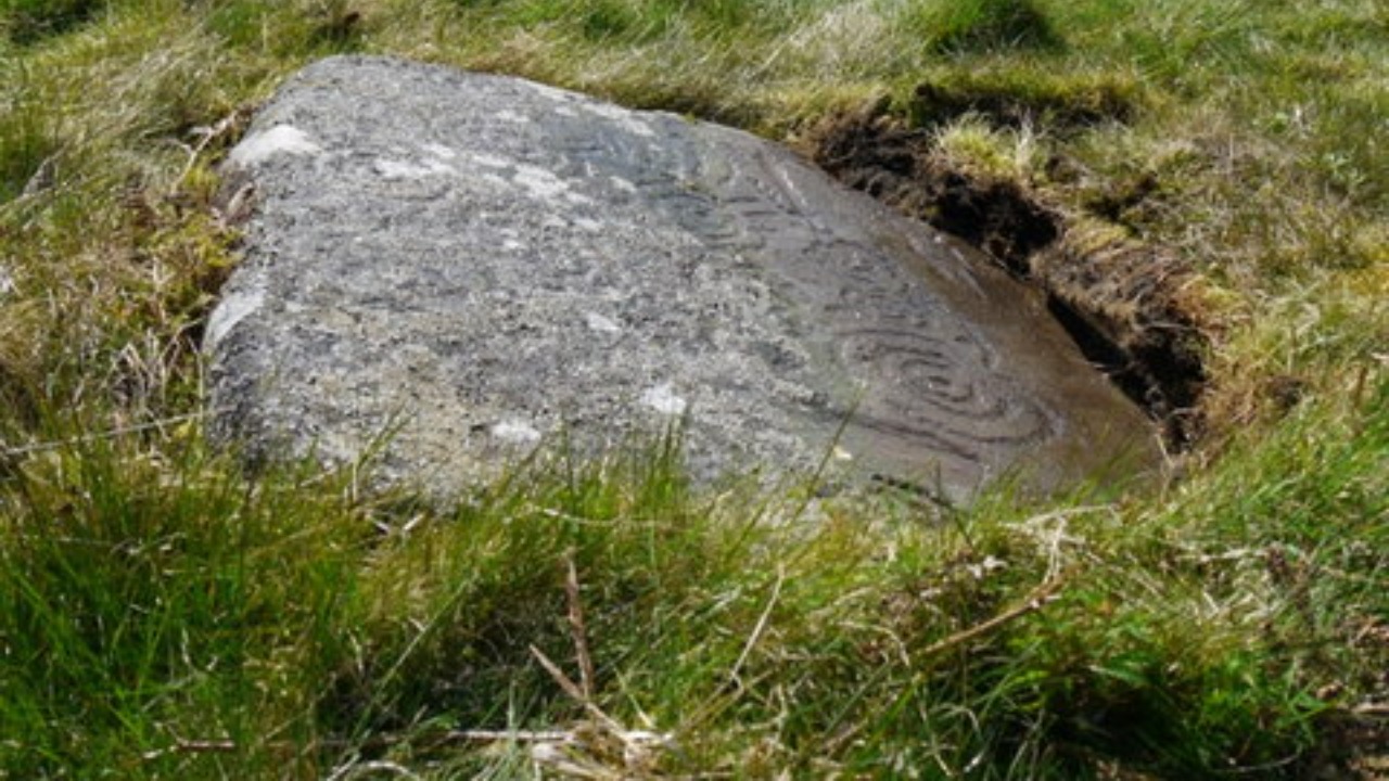
The Ségognole 3 cavern sits in France’s École River Valley, a landscape shaped by water, limestone, and deep time. For decades it was known to specialists mainly as one more prehistoric site in a region rich with Paleolithic traces, but recent work has drawn fresh attention to a cluster of engravings on its floor that had long been overlooked. Researchers now argue that these markings are not random scratches or purely symbolic motifs, but a deliberate attempt to model the surrounding terrain in three dimensions.
What makes the claim so striking is the setting itself. The École River Valley is carved by steep banks, meanders, and terraces, and the cave lies within walking distance of features that could plausibly be translated into carved ridges and depressions. According to researchers working at Ségognole 3, the engravings uncovered on the floor of the cave appear to echo that surrounding topography, suggesting that the people who made them were not only observing the landscape but encoding it in a tactile, spatial form.
Reading the engravings as a three‑dimensional landscape
At the heart of the argument is the way the Ségognole 3 engravings rise and fall across the rock surface. Rather than a flat panel of lines, the floor carries overlapping grooves, ridges, and depressions that together create a relief effect. When I look at how specialists describe these features, the case hinges on the idea that the carvers were intentionally using depth and contour to represent hills, valleys, and perhaps watercourses, turning the cave floor into a miniature terrain model that could be read by touch as much as by sight.
That interpretation aligns with a broader shift in archaeology toward treating prehistoric art as more than decoration. The suggestion that the Ségognole 3 engravings function as a 3D map implies that their makers had a mental image of the wider École River Valley and could translate that image into a scaled, abstracted form. The team behind the work argues that such a feat would require advanced spatial reasoning and a shared understanding of how carved lines and raised areas corresponded to real‑world features, which is why they describe the engravings as evidence of sophisticated mapping capabilities in early human societies.
What “oldest 3D map” really means
Calling any artifact the “oldest 3D map” is a bold move, and I find it useful to unpack what that phrase actually covers. In practice, archaeologists are talking about objects that combine three elements: a deliberate representation of a real landscape, a use of relief or depth rather than only flat lines, and a scale that compresses a larger area into a portable or bounded surface. The Ségognole 3 engravings appear to meet those criteria, which is why some experts now place them at the very beginning of the known 3D mapping tradition.
Yet the label is also a claim about chronology and context. To argue that a French cavern holds the earliest example, researchers must compare it to other contenders and show that it predates them while still clearly functioning as a map. That is where the debate becomes more than a catchy headline. The Ségognole 3 team is effectively saying that the cognitive leap to three‑dimensional cartography occurred long before the better known Bronze Age examples, and that it emerged among communities whose names and languages are lost but whose carved stones still carry traces of their mental worlds.
The Saint‑Bélec Slab and the previous mapping benchmark
Until the Ségognole 3 claims surfaced, the benchmark for early 3D mapping in Europe was a carved block of stone from Brittany known as the Saint‑Bélec Slab. First unearthed in 1900, the slab was later reexamined and identified as a stylized depiction of a local territory, with raised motifs and incised lines that together form a relief map. Specialists dated the Saint‑Bélec Slab to the Bronze Age and argued that its complex composition showed a community with both political organization and a strong sense of spatial control.
The Saint‑Bélec Slab became famous because its repeated motifs and structured layout looked unmistakably cartographic, with patterns that could be matched to known river systems and land divisions in Brittany. Researchers pointed to the presence of repeated motifs on the Saint‑Bélec Slab as evidence that it was not a random artwork but a deliberate representation of a specific area, and they argued that such a piece reflected the territorial organization and social hierarchy of the time. In that framework, the slab stood as the oldest known 3D map in Europe, a title that the Ségognole 3 engravings now potentially challenge.
How the cave engravings compare to the Saint‑Bélec Slab
When I set the Ségognole 3 engravings alongside the Saint‑Bélec Slab, the contrast is as revealing as the similarities. The slab is a single, transportable object, carved on a large but bounded surface that could, at least in theory, be moved, displayed, or buried as a unit. The cave engravings, by contrast, are fixed to the floor of a specific chamber, inseparable from the rock that holds them. That difference alone hints at distinct uses: one perhaps tied to formalized power or memory, the other embedded in a lived space that people entered and traversed.
Stylistically, both artifacts rely on repeated motifs and structured layouts, but the Saint‑Bélec Slab presents a more obviously organized composition, with patterns that can be correlated to known geographic features in Brittany. The Ségognole 3 engravings are subtler, their relief emerging from overlapping lines and contours that require careful study to decode. If the cave floor is indeed a 3D map, it may represent a more intimate or localized understanding of the École River Valley, one that was meant to be experienced in situ rather than displayed as a freestanding symbol of territory.
What the Ségognole 3 map suggests about prehistoric cognition
Accepting the Ségognole 3 engravings as a three‑dimensional map has far‑reaching implications for how I think about prehistoric cognition. It would mean that people living in or near the École River Valley were not only navigating their environment but abstracting it, compressing hills, valleys, and watercourses into a carved model that others could interpret. That kind of abstraction requires a mental leap from direct experience to representation, a capacity often associated with later, more complex societies.
It also suggests a shared visual language within the group that created the engravings. For a carved relief to function as a map, its makers and users must agree, at least implicitly, that certain shapes stand for certain features, and that the layout on the stone corresponds to the layout on the ground. The Ségognole 3 work, if correctly interpreted, points to a community that could coordinate around such conventions, passing on knowledge of the landscape through a medium that outlasted any single journey or generation.
Why early communities might have needed 3D maps
Understanding why a prehistoric group would invest time and effort in a 3D map helps ground the debate in everyday life rather than abstract theory. In a valley like the École, where resources such as water, game, and raw materials are distributed unevenly, a carved model of the terrain could serve as a teaching tool for younger members of the group, a planning aid for seasonal movements, or a way to remember routes that were not traveled every day. The tactile nature of a relief map would make it especially useful in low light or for people learning by touch.
There is also a social dimension to consider. A community that can represent its territory in stone can also claim it, narrate it, and perhaps negotiate over it. The Saint‑Bélec Slab has been interpreted as a sign of territorial control in Bronze Age Brittany, and while the Ségognole 3 engravings come from a very different context, they may reflect an earlier stage in the same trajectory, where mapping begins as a practical and mnemonic tool before becoming a marker of power. In that sense, the cave floor could be both a guide to the landscape and a quiet assertion of belonging within it.
The limits of the evidence and the risk of over‑interpretation
For all the excitement around Ségognole 3, I think it is important to acknowledge how fragile the evidence can be. Rock art is notoriously difficult to date precisely, and interpreting abstract engravings always involves a degree of inference. Without accompanying inscriptions or unambiguous depictions of recognizable landmarks, any claim that a set of lines forms a map must rest on patterns, correlations, and expert judgment rather than direct proof. That does not invalidate the mapping hypothesis, but it does place it on a spectrum of probability rather than certainty.
There is also the risk of projecting modern concepts of cartography onto societies that may have thought about space in very different ways. A carved relief that looks like a map to contemporary eyes might have served ritual, symbolic, or narrative functions that only partly overlap with navigation or territorial planning. The strongest arguments for Ségognole 3 as a 3D map come from the way its engravings appear to mirror the surrounding École River Valley, yet even that mirroring could have been embedded in myth or ceremony as much as in practical route‑finding. Recognizing those ambiguities keeps the conversation honest while still allowing room for bold interpretations.
How the discovery reshapes the story of European mapping
Even with those caveats, the Ségognole 3 engravings have already begun to reshape how I see the history of mapping in Europe. Instead of a narrative that starts in the Bronze Age with the Saint‑Bélec Slab and then accelerates with classical and medieval cartography, the timeline now appears more layered, with deep prehistoric roots that blur the line between art, ritual, and spatial science. The cave floor suggests that the impulse to model landscapes in three dimensions may have emerged long before formal states or written records, within small communities whose survival depended on intimate knowledge of their surroundings.
Placing Ségognole 3 alongside the Saint‑Bélec Slab also highlights the diversity of early mapping practices. One is a fixed, immersive surface in a cavern of the École River Valley, the other a carved block from Brittany that could be moved or hidden. One may have served as a communal tool for understanding local terrain, the other as a symbol of organized territory and authority. Together they show that the story of the “oldest 3D map” is not a single object’s biography but a broader shift in how humans learned to see their world from above, compress it into stone, and share that vision with others.
More from MorningOverview