A vast slab of rock in central Bolivia has turned out to be one of the most crowded dinosaur thoroughfares ever found, preserving an estimated 18,000 tracks along what was once a shallow coastal lake. The newly documented site captures a moment in the Late Cretaceous when meat‑eating theropods, plant‑eating sauropods, and other dinosaurs converged on the same watery edge, leaving behind a fossil traffic jam that now sets a global record for dinosaur footprints. For paleontologists, it is not just the raw number that matters, but the way these overlapping paths reveal how dinosaurs moved, fed, and even swam through a landscape that no longer exists.
The discovery, centered on the Carreras Pampa tracksite in Bolivia’s Torotoro National Park, turns a once obscure rock surface into a key archive of dinosaur behavior. By tracing thousands of individual steps, tail drags, and swim marks, researchers can reconstruct a dynamic ecosystem that stretched along an ancient shoreline, offering a rare, high‑resolution look at life between roughly 101 million and 66 million years ago.
Bolivia’s record‑breaking “dinosaur freeway” on an ancient coast
The Carreras Pampa surface is remarkable because it compresses an entire community of dinosaurs into a single exposed layer, effectively freezing a busy day along a Cretaceous lakeshore. Instead of a handful of isolated tracks, scientists have documented a dense network of overlapping paths that turns the rock into what they describe as a kind of “dinosaur freeway,” with footprints heading in multiple directions and at different speeds. The setting was once part of an ancient coastal plain, where fluctuating water levels left broad mudflats that could record every step before hardening into stone.
Researchers place Carreras Pampa within Torotoro National Park, a protected region in central Bolivia that already hosts other fossil tracksites but has never seen anything on this scale. The formal description of The Carreras Pampa track surface identifies it as an Upper Cretaceous site, tying it to a time when South America was home to large theropods and long‑necked sauropods that roamed near lakes and coastal inlets. Satellite and mapping views of the park show how the track‑bearing strata sit within a broader landscape of canyons and folded rock, and a detailed location view of the national park region is captured in a Torotoro map that situates Carreras Pampa within Bolivia’s rugged interior.
How 18,000 tracks turned one site into a world record
The headline figure is stark: scientists estimate roughly 18,000 individual dinosaur traces at Carreras Pampa, a tally that includes footprints, swim marks, and tail drags preserved across the exposed rock. That number alone makes the site stand out, since most tracksites around the world preserve hundreds or, at most, a few thousand prints. Here, the density is so high that nearly every square meter of the main surface carries some sign of dinosaur traffic, turning the area into what researchers now regard as the world’s most extensive dinosaur tracksite.
More detailed counts break that total into about 16,600 footprints and 1,378 swim tracks, along with several tail traces that record animals dragging their tails through shallow water. Those figures, reported as a total of nearly 18,000, 16,600, 1,378 individual marks, underscore just how intensively dinosaurs used this lakeshore. A separate analysis of the same site describes it as the 18,000 Tracks Discovered at what is now considered the World’s Largest Dinosaur Tracksite, highlighting how the combination of footprint counts and swim traces pushes Carreras Pampa past previous records.
Inside the Carreras Pampa tracksite: footprints, tail drags, and swim marks
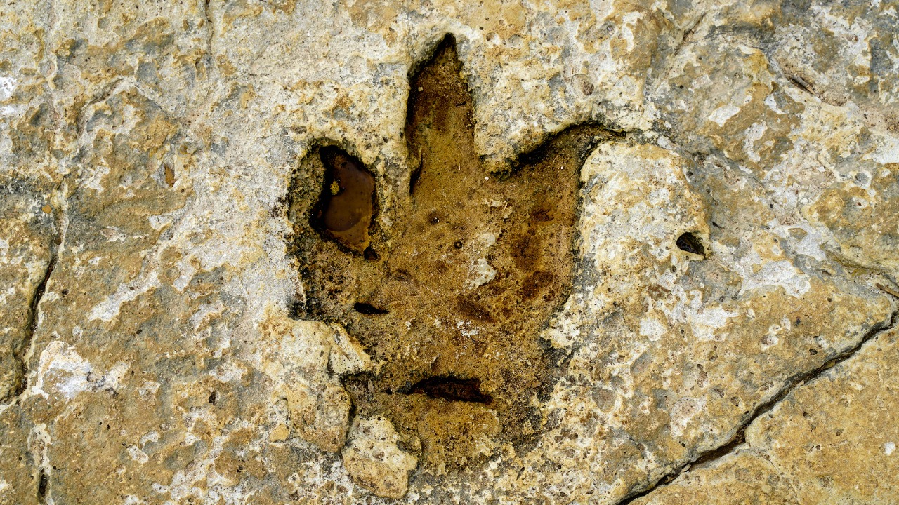
What makes Carreras Pampa scientifically rich is not just the volume of tracks but their variety. The main surface preserves classic three‑toed theropod prints, broader sauropod impressions, and a suite of unusual marks that record tails dragging and claws raking through water. Some trackways show animals walking steadily along the shoreline, while others capture sharp turns, changes in pace, and interactions with the water’s edge. Taken together, the surface reads like a storyboard of dinosaur behavior rather than a static snapshot.
The formal description of the site emphasizes that the Carreras Pampa surface in Torotoro National Park records thousands of Cretaceous dinosaur tracks, tail traces, and swim tracks, including evidence of tail dragging and even sharp turns preserved in the rock. That behavioral diversity is highlighted in a detailed overview of the Fossil Site in Bolivia Records Thousands of Cretaceous Dinosaur Tracks, Tail Traces, Swim Tracks, which notes how the abundance of different trace types allows paleontologists to infer not only which animals were present but how they moved through the environment. A focused section of the scientific paper on behaviors indicated by the trackways further breaks down how specific patterns, such as parallel paths or sudden shifts in direction, point to herd movement, foraging, or cautious approaches to deeper water.
A crowded lakeshore: what the tracks reveal about dinosaur behavior
When I look at the layout of the Carreras Pampa tracks, what stands out is how they cluster and cross, suggesting that dinosaurs were not just passing through but repeatedly returning to the same shoreline. The concentration of footprints near what would have been the water’s edge hints at a shared resource, likely a shallow lake that offered drinking water, vegetation, and perhaps fish or invertebrates for opportunistic feeders. The presence of both walking tracks and swim marks indicates that some animals waded in until they lost firm footing, then paddled, leaving claw scrapes on the lake bottom.
Researchers interpret this pattern as evidence that the lake was a valuable resource for the animals living nearby, with the sheer preponderance of tracks pointing to repeated visits over time rather than a single mass event. One analysis notes that The lake at Carreras Pampa, the researchers say, was central to the local ecosystem, and that the density of tracks reflects how dinosaurs congregated along its margins. Another report on the same site underscores that the abundance of imprints shows dinosaurs were not evenly spread across the landscape but instead funneled into this lakeshore, where they left overlapping paths that now serve as a proxy for crowding and repeated use.
Theropods, sauropods, and more: who left the marks?
Although no bones have been reported directly from the Carreras Pampa surface, the shapes and sizes of the tracks point to a diverse cast of dinosaur trackmakers. Three‑toed prints with sharp claw marks are typical of theropods, the group that includes predators such as abelisaurids and other carnivores that roamed South America in the Late Cretaceous. Broader, more rounded impressions with multiple toe pads likely belong to sauropods, the long‑necked giants that would have towered over the shoreline as they moved between feeding grounds.
Field descriptions of the site refer to a “dinosaur freeway” dominated by theropod tracks, with some prints large enough to suggest sizeable predators pacing the mud. A report on the Bolivian dinosaur freeway notes that the surface is crisscrossed by meat‑eating theropods, while other trackways point to heavy, plant‑eating dinosaurs that trudged through the same area. A more detailed breakdown of the footprint counts explains that scientists documented over 16,000 footprints across roughly 7,485 square meters, a density that implies multiple species using the same corridor. That figure is echoed in a focused summary that notes Scientists document over 16,000 footprints in the world’s most extensive dinosaur tracksite, reinforcing the idea that Carreras Pampa was a shared pathway rather than a single‑species trail.
From mud to monument: how the tracks were preserved
Transforming a muddy lakeshore into a fossil archive requires a precise sequence of events, and Carreras Pampa appears to have benefited from just the right conditions. Dinosaurs first had to walk across soft, cohesive sediment that could hold a clear impression without collapsing. Those prints then needed to dry or firm up before being buried by a new layer of sediment, protecting them from erosion. Over millions of years, the stacked layers were compressed and lithified into rock, then later uplifted and exposed by erosion so that modern researchers could find them.
Analyses of the Bolivian site emphasize that the lake’s fluctuating water levels and fine‑grained muds were key to this preservation. One overview notes that the Carreras Pampa surface is now one of the world’s important dinosaur tracksites, with the highest recorded number of tracks in a single locality, precisely because the sedimentary environment repeatedly captured and sealed in footprints. Another report on the same discovery explains that the mud was deep and soft enough for theropods to stamp their feet between roughly 101 million and 66 million years ago, a timeframe summarized in a description that notes There the theropods stamped their feet into the soft, deep mud between 101 m and 66 m years ago, before tectonic forces tilted and exposed the track‑bearing layer.
Reading the rock: what the trackways say about movement and environment
Trackways at Carreras Pampa do more than mark presence; they encode information about speed, direction, and even social behavior. Parallel sets of footprints that maintain consistent spacing can indicate animals moving together, while solitary paths that weave or change stride length may reflect individuals exploring the shoreline. Swim tracks, where only the tips of claws scratched the substrate, reveal moments when dinosaurs were buoyant, paddling through deeper water rather than walking on the bottom.
The scientific analysis of the site’s trackways highlights how these patterns translate into behavioral interpretations. A detailed section on the behaviors indicated by the trackways notes that some sequences show steady, directional movement along the lakeshore, while others capture abrupt turns that may signal avoidance or pursuit. A broader summary of the fossil site explains that the abundance of imprints shows dinosaurs were not randomly scattered but instead concentrated along a narrow band of shoreline, a pattern echoed in a report that states the abundance of imprints shows dinosaurs were using the lake margin intensively rather than spreading out across a wider area. That interpretation is reinforced in a discussion of how The abundance of imprints shows repeated use of the same corridor, turning the rock into a record of movement patterns rather than a random scatter of isolated steps.
How scientists documented the “world’s most extensive” tracksite
Capturing the full complexity of Carreras Pampa required more than a quick field visit. Researchers mapped the surface in detail, tracing individual trackways and cataloging each footprint, swim mark, and tail drag. High‑resolution photography, drone surveys, and 3D modeling allowed them to build a digital replica of the site, which is essential for analyzing track orientations, spacing, and depth without relying solely on field sketches. This systematic approach turned a chaotic‑looking surface into a structured dataset that could be analyzed for patterns.
The scale of the effort is reflected in reports that describe scientists documenting over 16,000 footprints across thousands of square meters, a task that demanded careful measurement and classification. One account notes that scientists document over 16,000 footprints in the world’s most extensive dinosaur tracksite, emphasizing how the team had to distinguish overlapping prints and identify which belonged to walking animals versus swimmers. A separate summary of the discovery underscores that Scientists have discovered a record‑breaking number of fossilized dinosaur footprints and swim tracks in a national park, highlighting the combination of fieldwork and digital tools that turned Carreras Pampa into a quantified, analyzable record rather than a mere curiosity.
Why Carreras Pampa matters for South American dinosaur history
For South American paleontology, Carreras Pampa fills a crucial gap by providing a high‑density record of dinosaur activity in a region better known for skeletal fossils than for trackways. Bones can tell researchers which species lived in an area, but tracks reveal how those animals moved through their environment and how often they used particular habitats. In Bolivia, where the fossil record is still being pieced together, a site that preserves thousands of steps along an ancient shoreline offers a complementary line of evidence about dinosaur ecology.
Reports on the discovery stress that Carreras Pampa is now one of the world’s important dinosaur tracksites, with the highest recorded number of tracks in a single locality, and that it offers a rare insight into a once‑thriving ecosystem. One analysis notes that Carreras Pampa, the researchers say, is now recognized as a key site for understanding how dinosaurs used lakeshore environments in the Late Cretaceous. A broader overview of the fossil site in Bolivia reinforces that the thousands of Cretaceous dinosaur tracks, tail traces, and swim tracks preserved there help reconstruct a dynamic coastal ecosystem, tying local geology to global questions about dinosaur behavior and habitat use.
From national park to global spotlight
Torotoro National Park has long been a destination for travelers interested in caves, canyons, and scattered dinosaur footprints, but the documentation of 18,000 tracks at Carreras Pampa pushes it into a different league. The park now hosts what researchers describe as the world’s most extensive dinosaur tracksite, a distinction that is likely to draw more scientific teams and, inevitably, more visitors. Managing that attention while protecting the fragile rock surface will be a central challenge for Bolivian authorities and local communities.
Descriptions of the site’s setting emphasize that Carreras Pampa lies within a protected landscape that already balances tourism and conservation, with established trails and viewing areas that can be adapted to showcase the new discovery. A detailed scientific account of The Carreras Pampa tracksite in Torotoro National Park, Bolivia, underscores that the site’s scientific value depends on keeping the surface intact, since erosion, vandalism, or unregulated foot traffic could quickly damage the delicate impressions. A more general overview of the park’s location and geology, captured in the Torotoro map view, shows how the tracksite fits into a broader network of fossil localities that, together, are turning this corner of Bolivia into a focal point for dinosaur research.
More from MorningOverview