Deep beneath East Africa, the planet is quietly rewriting its own map. A colossal crack is opening in the crust, slowly enough that no one alive today will see the final result, yet fast enough that scientists can already trace the outline of a future ocean. What looks like a dramatic gash in the ground is, in reality, the first visible chapter in the birth of a new ocean basin.
The day the ground split open
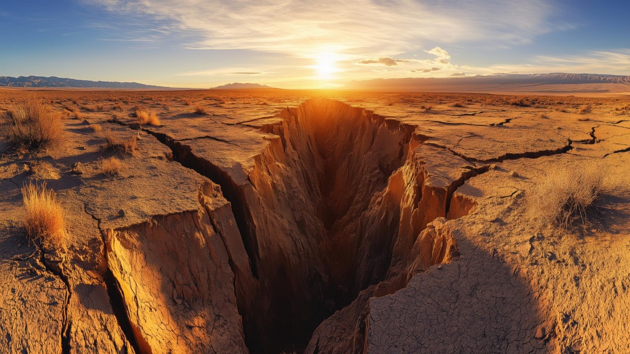
When a large chasm suddenly tore through farmland and a busy road in Kenya, it offered a rare, unsettling glimpse of tectonic forces that usually move in silence. The feature, described as a Large crack in the East African Rift stretching several kilometers, was not just a local curiosity. It was physical evidence that the African continent is being pulled apart along a deep fracture zone that runs from the Red Sea down toward Mozambique. For residents, the sight of asphalt and soil ripped open overnight was shocking. For geologists, it was a vivid confirmation that the rift is active and that the continent is, quite literally, in the process of dividing.
That Kenyan rupture sits within the broader East African Rift system, where the ground is thinning and sinking as tectonic plates drift away from each other. Toward the Afar region in the northeast, the rift branches and widens, affecting areas that include the Horn of Africa and parts of northern Ethiopia. Scientists see these dramatic surface breaks as part of a much longer timeline in action, a sequence in which the crust first fractures, then stretches, and eventually gives way to a new ocean basin. The crack that startled drivers and farmers is one frame in a geologic movie that will play out over millions of years, but it captures the scale of what is underway.
Africa’s hidden tectonic tug-of-war
Below the surface, the African continent is caught in a slow-motion tug-of-war between massive slabs of rock. The landmass is not a single unbroken plate, but a mosaic that includes the Nubian Plate to the west and the Somali Plate to the east, which are gradually peeling away from each other. In the Afar region, a desolate landscape of lava fields and salt flats sits at the junction of three tectonic plates that are very slowly separating, a configuration that Scientists describe as The African continent very slowly peeling apart. That triple meeting point is one of the few places on Earth where the birth of an ocean can be observed in real time, at least in geologic terms.
Each plate boundary in this Afar region is spreading, driven by hot material rising from deep within the mantle and weakening the overlying crust. Over time, these rifting events will reshape the African continent, carving out a new configuration of land and sea. Researchers studying how Over time, these rifting events will reshape the African landmass point to differences in crustal thickness and density that make East Africa particularly prone to splitting. The result is a slow but relentless widening of the rift, as if an invisible wedge were being driven through the continent from the Red Sea inland.
From crack to ocean basin
What begins as a fracture in the ground eventually becomes something far larger. In the early stages, magma rises to fill gaps in the crust, volcanic activity increases, and the land between diverging plates subsides. Over millions of years, that subsiding zone can sink below sea level, allowing water to rush in and form a new ocean. In East Africa, scientists say a new ocean is being born along this line of weakness, with the Afar Depression already resembling a young ocean floor in places. The region is described as one of the most Scientists say a new ocean is being born in one of the planet’s unique spots, because it captures several stages of rifting in a relatively compact area.
Geophysicists often compare this process to the early history of the Atlantic, which also began as a rift that split a supercontinent apart. In East Africa, the same script appears to be unfolding, with the Red Sea and the Gulf of Aden already marking zones where oceanic crust has formed between diverging plates. As the crack widens and deepens, the land between the Nubian and Somali plates will likely drop further, eventually creating a continuous seaway that connects to existing oceans. The transformation from land to ocean is not a sudden event but a gradual transition, as lava flows, faulting, and subsidence slowly remodel the landscape into a future ocean basin.
The 35-mile rift that stunned Ethiopia
One of the clearest signs that this tectonic drama is well underway came when a 35 mile long rift opened in Ethiopia, cutting across the desert in a matter of days. For many observers, images of this gaping fissure were the first visceral proof that Africa is literally splitting apart. The event, widely shared and analyzed, has been cited as A 35 mile rift opened in Ethiopia, proof that Africa is literally splitting apart, and it offered a rare opportunity for scientists to watch a continental rift grow almost in real time. The scale of the crack, visible from satellite imagery and on the ground, underscored how quickly strain can be released when the crust finally gives way.
Researchers who study this Ethiopian segment of the rift emphasize that the underlying process has been underway for millions of years, even if the surface expression sometimes appears suddenly. Measurements suggest that the plates here are moving apart at rates of millimeters to centimeters per year, a pace that is imperceptible day to day but dramatic when released in a single rupture. The 35 mile tear did not start the rift, and it will not finish it, but it serves as a striking marker of how far the continent has already progressed along the path from solid landmass to fragmented terrain that will one day host a new ocean.
Tracking a continent’s slow escape
To understand where this is all heading, scientists have turned to precise instruments that can track the motion of the ground itself. Using GPS and satellite data, researchers have followed the movements of the tectonic plates beneath northern Ethiopia, watching as the land shifts by tiny increments year after year. These measurements show that the region is stretching apart, confirming that the rift is not a static scar but an active boundary that is widening over time. One analysis notes that Using GPS and satellite data, scientists have tracked the plates under northern Ethiopi, revealing a pattern of motion that matches models of a nascent ocean basin.
These satellite based observations are crucial because they allow geologists to quantify a process that would otherwise be inferred only from earthquakes and volcanic eruptions. By comparing GPS stations anchored on different sides of the rift, scientists can calculate how quickly the Nubian and Somali plates are diverging and how strain accumulates before it is released in events like the Ethiopian fissure. The data suggest that while the pace is slow on human timescales, the direction is unmistakable. Over a few million years, the cumulative effect of these tiny shifts will be enough to tear a new ocean wide open, even if the people living on the rift today only ever see modest changes in their lifetimes.
Where the sixth ocean is taking shape
In East Africa, the rift is not just a line on a map but a sprawling zone of volcanoes, hot springs, and thinning crust that stretches across several countries. In this region, tectonic forces are slowly splitting the continent in two, creating a future ocean basin that some researchers describe as a potential sixth ocean. Reports on how In East Africa, tectonic forces are creating a future ocean basin highlight that since 2005, a 35 mile long dike intrusion has been recorded in the region, linked to intense volcanic activity. This combination of stretching and magma injection is exactly what geologists expect to see when a continent begins to transition toward an oceanic state.
The idea of a sixth ocean forming here is not just a poetic label. As the rift deepens and widens, seawater from the Red Sea and the Gulf of Aden could eventually flood into the low-lying areas, isolating the Horn of Africa and adjacent regions as a separate landmass. The Afar Depression already lies below sea level in places, and its geology resembles that of young oceanic crust. If current trends continue, the rift valley could evolve into a narrow seaway, then a wider body of water, and finally a fully fledged ocean that joins the global network of interconnected seas. For now, the landscape remains a patchwork of high plateaus and deep valleys, but the tectonic blueprint of a new ocean is already etched into the rock.
How the map of Africa could be redrawn
The long term implications of this rifting are profound. Millions of years from now, Northern Africa could look very different, with a new ocean separating parts of the continent from the rest of the landmass. Some projections suggest that the Horn of Africa and neighboring regions could detach and drift away, forming an island like block that edges closer to the nearby Saudi Arabian Peninsula. One account notes that Millions of years from now, Northern Africa could be split by a seaway edging toward the nearby Saudi Arabian peninsula, a scenario that would redraw coastlines and reshape regional geography.
Such a transformation would not be unprecedented in Earth’s history. The breakup of earlier supercontinents created new oceans and rearranged continents in ways that profoundly altered climate, ocean circulation, and ecosystems. In Africa’s case, the emergence of a new ocean would create fresh coastlines, new marine habitats, and different patterns of rainfall and temperature on either side of the divide. While these changes lie far beyond any human planning horizon, they underscore how dynamic the planet’s surface really is. The map that seems fixed in school atlases is, in reality, a snapshot of a work in progress, with East Africa currently one of the most active construction zones.
Life along the great rift
For people living along the rift, the story is not just about distant futures but about present day risks and opportunities. The same forces that are tearing the continent apart also fuel volcanoes, earthquakes, and geothermal systems that shape daily life. Analyses of the region describe how Africa’s splitting plates could give birth to a new ocean, but with consequences for communities across Africa, from disrupted infrastructure to the potential for harnessing geothermal energy. Towns built near active faults must contend with ground deformation and occasional seismic events, while farmers adapt to soils and water systems influenced by volcanic activity.
At the same time, the rift offers resources that can be a lifeline in a warming world. Geothermal fields provide low carbon energy options, and rift lakes support fisheries and agriculture for millions of people. The challenge is that the benefits and hazards are intertwined. Roads can be cut by sudden cracks, as seen in Kenya, even as the same tectonic setting creates hot springs that power local grids. Managing life along the great rift means planning for a landscape that is inherently unstable, yet also rich in potential, as the continent slowly evolves toward its next configuration.
Afar: the frontline of a new ocean
Nowhere is the future ocean more tangible than in the Afar Depression, a harsh, low lying region where the crust is stretched thin and the heat from below is close to the surface. This desolate expanse sits atop the juncture of three tectonic plates that are peeling away from each other, making it a natural laboratory for studying how continents break apart. Scientists describe how This desolate expanse sits atop the juncture of three plates and could become an ocean basin millions of years from now, with lava filled fissures and thin crust that resemble the early stages of a mid ocean ridge. Standing here, it is possible to see in one direction the highlands of Ethiopia and in the other the low, salt crusted flats that hint at a future seafloor.
The Afar region also connects the inland rift to existing bodies of water, including the Red Sea and the Gulf of Aden, which already occupy zones of oceanic crust between diverging plates. As the rift propagates and the crust continues to thin, these seas could eventually extend into Afar, flooding the depression and linking it to the wider ocean. For now, the area remains a stark, largely uninhabited landscape, but its geology tells a clear story. The crack that began as a subtle line in the crust has grown into a complex network of faults and volcanic centers that mark the frontline of a continent in the process of division.
What the crack means for the rest of us
It is tempting to treat the East African Rift as a distant curiosity, a slow moving spectacle with no bearing on daily life elsewhere. Yet the forces at work there are part of the same global tectonic system that shapes coastlines, mountain ranges, and earthquake zones around the world. As geologists point out, the growing tear in Kenya has already prompted renewed questions about whether the African continent is splitting in two and what that means for long term stability. One report notes that Geologists say the growing tear has raised questions about the African continent splitting in two in millions of years, a reminder that even seemingly solid landmasses are temporary arrangements.
For the wider world, the slow birth of a new ocean in East Africa is a powerful illustration of how dynamic Earth remains, even in an age dominated by human activity. While climate change, urbanization, and technology occupy most of the headlines, the planet’s deep interior continues to rearrange continents on its own schedule. The crack that will one day host a new ocean is a stark, physical reminder that our maps are provisional and that the ground beneath our feet is part of a much larger, ongoing story of planetary change.
More from MorningOverview