Volcanoes and earthquakes have always shared the same restless roots, but the numbers that drive public fear are not always the ones scientists are actually using. A viral claim that a swarm of 10,000 quakes means a 95 percent chance of a major eruption sounds precise, yet it mashes together statistics from very different hazards and regions. I want to unpack what experts are really saying about seismic swarms, eruption odds, and long term risk, and why the most alarming numbers circulating online do not match the official assessments.
Across the West Coast, from the Cascades to Northern California, researchers are tracking thousands of tiny tremors and subtle ground shifts, but they are not declaring that any specific volcano is on the brink of a catastrophic blast. Instead, they are drawing a careful line between what is possible, what is probable, and what is actually happening in the rock beneath our feet right now. That distinction matters, because it is the difference between panic and preparation.
How a 95 percent earthquake statistic morphed into an eruption scare
The figure at the heart of the latest panic, a supposed 95 percent chance of a major volcanic eruption, does not come from volcano science at all. It traces back to long term seismic forecasts in which Scientists estimate there is a 95 percent chance of one or more magnitude 6.7 or greater earthquakes striking Northern California over a multi decade window. That forecast is about tectonic faults, not magma, and it reflects the long history of big quakes along the plate boundary rather than any sudden new swarm. When that probability is ripped from its context and pasted onto a volcano rumor, it turns a sober, slow burn risk assessment into a false countdown clock.
The confusion deepens because the same forecast notes that other regions are “Also” not immune to strong earthquakes, which some readers have interpreted as a blanket warning that the entire West Coast is primed for simultaneous disaster. In reality, the California Earthquake Probability Map is a planning tool that helps cities, utilities, and insurers understand where damaging shaking is most likely over decades, not a live alert that a volcano is about to erupt this week. When people conflate that long horizon with a short lived swarm of small quakes under a single peak, they end up treating a statistical likelihood as if it were a specific prediction.
What USGS is actually saying about current volcano activity
While social media posts race ahead with talk of imminent catastrophe, the official language from federal scientists is far more measured. The U.S. Geological Survey runs a standing series of volcano updates that track seismicity, gas emissions, and deformation at monitored peaks, and those bulletins are the closest thing the public has to a real time dashboard of volcanic behavior. When the agency sees a pattern that truly suggests magma is moving toward the surface, it raises alert levels and spells out what kind of eruption might follow, from minor ash bursts to larger explosive events.
Right now, those alerts do not match the viral narrative of a region wide emergency. In its most recent Newest Volcano Notice for the Cascades, the agency’s Activity Update states that All volcanoes in the Cascade Range of Washington and Oregon are at normal background activity levels. That list explicitly includes well known names like Mount St. Helens and Crater Lake, which have real histories of eruption but are not currently showing the kind of escalating unrest that would justify talk of a 95 percent eruption probability.
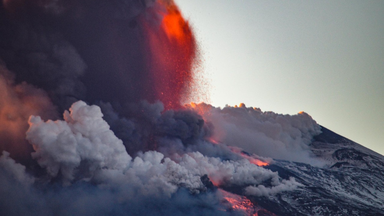
Mount Rainier’s swarm: 1,000 quakes, not 10,000, and what that means
The most recent flashpoint for fear has been Mount Rainier, where a burst of small earthquakes over the summer fueled claims that “America’s deadliest volcano” was waking up. The numbers there are significant but more modest than the viral posts suggest. Over a span from early July through the end of the month, there were More than 1,000 small quakes recorded under the mountain, a clear uptick from the usual trickle of events but nowhere near the 10,000 figure that has been circulating. That swarm was enough to catch the attention of seismologists, who compared it to a shorter burst in 2019 that produced about 120 quakes, yet they emphasized that the energy involved was still low and that the pattern did not match magma forcing its way upward.
Context matters here, and the historical record helps. According to regional monitoring, Rainier‘s last minor eruption was recorded in 1884, while its last major eruptive period occurred roughly a thousand years ago. That long quiet stretch does not mean the volcano is safe forever, but it does show that even a cluster of hundreds of tiny quakes can come and go without leading to an eruption. When I weigh that history against the current data, the leap from 1,000 small events to a supposed 95 percent chance of a major blast looks less like science and more like a game of telephone gone wrong.
USGS says Rainier is back to typical seismic levels
One of the clearest signals that the Rainier swarm was not the start of a runaway crisis is what happened next. After the burst of activity in July, the pace of quakes tapered off, and by late summer the pattern had settled back into its usual rhythm. In its own language, the agency reported that Earthquake activity at Mount Rainier had returned to typical rates of seismicity after the swarm that began earlier in the summer. That kind of reversion to background is exactly what scientists expect from many swarms that are driven by small shifts in the crust or fluids moving through existing cracks rather than by fresh magma rising toward the surface.
It is also telling that, despite the attention Rainier received, the official alert level for the volcano did not spike into the higher tiers that would signal a likely eruption. Instead, the mountain remained in a normal monitoring posture, with instruments continuing to track any new changes but without the color coded escalation that accompanies more serious unrest. When I compare that steady stance to the breathless tone of some online posts, the gap between expert assessment and public perception becomes stark.
Underwater Oregon volcano: a long fuse, not an immediate blast
Another thread feeding the sense of a looming West Coast eruption has been fresh research on an underwater volcano off the coast of Oregon. Scientists studying that seafloor system have concluded that it could erupt within a relatively defined window, but their timing is still measured in years, not days. Based on patterns of inflation and past cycles, they now expect that the submarine volcano off Oregon likely will not erupt until mid to late 2026, even though earlier models suggested it could erupt within a year.
That adjustment is a reminder that volcanic forecasts are probabilistic and that they evolve as new data comes in. The same study notes that, in December of a previous cycle, the volcano showed signs that helped refine the expected timing, which is why the current estimate now stretches into the middle or later part of 2026. When I look at that timeline, it is hard to square it with any claim that a 10,000 quake swarm has pushed the system to a 95 percent chance of an immediate major eruption. Instead, the underwater volcano reads as a slow moving, closely watched experiment in how magma systems breathe over years.
Yellowstone’s supervolcano: overdue myths versus monitored reality
No discussion of American eruption fears is complete without Yellowstone, which has become a magnet for doomsday speculation. The phrase “overdue” gets thrown around so often that it can sound like a scientific verdict, yet the people who actually study the caldera are blunt about the odds. When they are asked, “Is Yellowstone’s supervolcano overdue for an eruption?” their answer is clear: Is Yellowstone overdue? Not anytime soon. The system does release energy, but it does so through a mix of smaller eruptions, ground deformation, and hot water activity rather than through constant cataclysms.
In fact, one of the most common expressions of Yellowstone’s restlessness is not lava at all but Hydrothermal explosions, where superheated water flashes to steam and blasts out craters in the park’s geyser basins. Those events can be dangerous on a local scale, especially to visitors who stray off boardwalks, yet they are a far cry from the continent reshaping eruptions that dominate popular imagination. When I weigh that nuanced picture against the blanket claim of a 95 percent chance of a major eruption, it becomes clear that the number is being misapplied to a system that is being watched precisely so that any real change in behavior would be caught early.
San Jose and the San Andreas: where quakes, not eruptions, are the main threat
Part of the confusion around the 95 percent figure comes from the way people blend together different kinds of seismic risk. In places like San Jose, the primary concern is not volcanic at all but tectonic. In San Jose, several major faults intersect the city and nearby communities, and it is the largest city on the north San Andreas fault segment. That geography explains why long term forecasts assign such a high probability to strong shaking in Northern California, but it does not imply that magma is on the move beneath the city or that an eruption is likely.
When I see people in the Bay Area sharing posts about a 10,000 quake swarm and a 95 percent chance of a major eruption, I suspect they are reacting to a very real earthquake hazard with the wrong mental model. The infrastructure that needs retrofitting in San Jose, from older apartment buildings to freeway overpasses, is vulnerable to ground shaking, not lava flows. Preparing for that reality means bolting homes to foundations, securing gas lines, and updating building codes, not scanning the horizon for ash plumes.
How scientists actually gauge volcanic risk, from threat layers to local updates
Behind every alert level and probability estimate is a web of instruments and analyses that rarely make it into viral posts. The USGS, formally known as the U.S. Geological Survey, maintains a National Volcanic Threat Layer that ranks volcanoes based on factors like past activity, nearby population, and the complexity of their magma systems. That framework is built on systematic Survey work rather than on any single swarm, and it feeds into the Volcano Hazards Pro tools that local officials use to plan evacuations and land use.
At the same time, regional observatories issue frequent bulletins that drill down into the behavior of individual peaks. The Newest Volcano Notice for the Cascades, for example, is not just a status light but a short narrative that explains why the Activity Update concludes that all monitored volcanoes in the Cascade Range of Washington and Oregon are at background levels. When I read those technical notes alongside the broader threat rankings, I see a layered approach that is far more cautious and data driven than the blunt “95 percent” label suggests.
Translating expert nuance into public language (and why jokes can help)
One of the challenges in covering these topics is that the language scientists use to describe uncertainty does not always land with a general audience. Probabilities over decades, background seismicity, and hydrothermal explosions can sound abstract compared with a simple, scary number. That is why some communicators lean on humor to bridge the gap. In a recent social media clip about Mount Rainier, a presenter quipped that earthquakes are “always groundbreaking, they break the ground” and then added, “They’re not always breaking bad. They‘re not always a sign of disaster, and if that pun made you groan, Sorry.” The joke works because it acknowledges the fear while gently undercutting the idea that every tremor is a prelude to catastrophe.
As I parse the current wave of eruption rumors, I find myself trying to strike a similar balance. It is important not to minimize the real dangers that volcanoes and earthquakes pose, especially in densely populated corridors along the West Coast. At the same time, it is just as important not to inflate a cluster of 1,000 small quakes into a 10,000 event crisis or to paste a 95 percent tectonic forecast onto a volcanic system that experts say is at normal background levels. Clear, grounded communication, whether in a formal bulletin or a pun filled video, is one of the best tools we have to keep that balance.
Why the numbers still matter, even when the sky is not falling
Stepping back from the noise, the real story in the current data is not that a major eruption is almost certain, but that the systems designed to catch early warning signs are working as intended. The Rainier swarm was detected quickly, analyzed in detail, and then folded back into a long term record that stretches from its last minor eruption in 1884 to the present. The underwater volcano off Oregon is being tracked closely enough that scientists can revise their expectations from “within a year” to “mid to late 2026” as new measurements come in. Yellowstone’s hydrothermal fields are mapped and monitored so that even small explosions can be studied and factored into future risk assessments.
Those efforts do not eliminate risk, but they do give communities a better chance to prepare in ways that match the actual hazards they face. For some, that means earthquake retrofits and emergency kits tailored to the likelihood of a magnitude 6.7 event. For others, it means evacuation routes that account for lahars or ash fall from a volcano that is quiet today but ranked high on the National Volcanic Threat Layer. When I hear someone say there is a 95 percent chance of a major eruption after 10,000 quakes, I now translate it into a more accurate, if less dramatic, sentence: scientists are watching a restless planet with increasingly precise tools, and the real odds depend on the details that get lost when complex forecasts are boiled down to a single, scary number.
More from MorningOverview