Death Valley has just rewritten its own record book, logging more rain in a single event than any time in at least 115-year of measurements, and the fallout is still unfolding on the ground. Even as the desert absorbs more than 1.75 inches of rare moisture, key roads remain shut, visitors are being turned away from favorite viewpoints, and the park’s famously harsh landscape is revealing how fragile its infrastructure can be when water finally arrives.
I see a story here that is bigger than a freak storm: a collision between climate extremes, a park system stretched by repeated disasters, and travelers who now have to navigate a place where “closed” signs are becoming as common as the iconic thermometer photos. The new rainfall benchmark is a warning that the driest place in North America is not immune to intensifying swings between drought and deluge, and that the way we plan, visit, and even imagine Death Valley will have to adjust.
Record-shattering rain in the driest place in North America
The headline number is stark: Death Valley has broken a 115-year rainfall record after a single storm dumped more than 1.75 inches of water on terrain better known for triple-digit heat than puddles. For a landscape that typically measures annual precipitation in fractions of an inch, that kind of sudden soaking is not just unusual, it is transformative, and it instantly vaults this event into the park’s short but dramatic list of hydrologic milestones in the driest place in North America. The new benchmark, documented through federal monitoring, underscores how even the most arid corners of the continent are now seeing more volatile swings between bone-dry and flooded conditions than their historical averages would suggest, a pattern that is increasingly central to how I interpret Western climate risk.
What makes this storm so significant is not only the raw total but the way it shattered expectations built over more than a century of record keeping. The 115-year figure is not a casual estimate, it reflects formal measurements that tie the deluge to long-term climate data maintained by agencies such as the National Oceanic and Atmospheric Administration, which tracked the more than 1.75 inches that fell on Death Valley and confirmed that the event eclipsed anything in the instrumental record for this particular slice of desert. That context, laid out in detail in analyses of Death Valley rainfall, is what turns a dramatic storm into a benchmark moment for climate watchers and park managers alike.
How a single storm ripped through Death Valley National Park
Behind the record numbers is a very physical story of water moving across rock, sand, and pavement in ways that the park’s infrastructure was never fully built to handle. A large storm system swept into Death Valley National Park and quickly overwhelmed washes and canyons, sending torrents across roadways and into low-lying areas that usually only see dust devils and heat shimmer. In a place where the ground is often baked so hard that it repels water instead of absorbing it, that kind of sudden runoff behaves more like a river than a rain shower, undercutting shoulders, peeling away asphalt, and carving new channels that ignore the neat lines on a visitor map.
Park officials have described how this particular storm triggered widespread flooding that forced immediate closures and set off a chain of inspections, damage assessments, and emergency repairs that will stretch long beyond the last raindrop. Reporting compiled from Interior Department releases details how the large storm caused flooding across multiple corridors of Death Valley National Park, prompting managers to shut down access and warn that additional closures could be necessary as evaluations continue, a sequence captured in coverage of the large storm that set this crisis in motion. For me, that chain reaction illustrates how a single meteorological event can ripple through every aspect of park operations, from road crews to search and rescue.
Roads washed out and a park carved into isolated pockets
The most immediate impact for visitors is simple and frustrating: many of the roads that make Death Valley accessible are now closed, turning what is usually a vast, drive-through landscape into a patchwork of isolated pockets. The National Park Service has issued an Alert that explicitly notes Many roads closed due to flooding on 11/18/2025, a blunt summary of how the storm severed key arteries and left popular routes impassable. When a park that spans thousands of square miles loses its main paved corridors, the effect is not just inconvenience, it is a fundamental reshaping of how people can move through the desert, with some trailheads and viewpoints effectively cut off until heavy equipment can rebuild the ground beneath them.
Those closures are not limited to a single notice or a handful of minor spurs. An updated Alert lists Several park roads closed after the same flooding event, and the agency has paired that with a formal Severity rating that reflects the scale of the disruption, including a Flood Watch that underscores the risk of additional damage if more storms arrive before repairs are complete. The evolving list of shutdowns and warnings is laid out in the park’s own Park Closure information, which has become essential reading for anyone trying to plan a trip. I read those updates as a reminder that in a place defined by extremes, access is always provisional, contingent on what the last storm left behind.
Inside the official response: Alerts, Severity, and a long repair slog
From the moment the floodwaters began cutting across pavement, the National Park Service shifted into emergency mode, leaning on its established system of Alerts and Severity ratings to communicate just how disruptive the storm had been. The agency’s conditions page for Death Valley now opens with a clear warning that Many roads closed due to flooding on 11/18/2025, framed within an Alert that signals a closure level rather than a minor advisory. That language is not accidental, it is part of a standardized vocabulary that helps visitors, tour operators, and even other agencies understand that this is not a routine washout that will be fixed in a weekend, but a park-wide event that will take sustained work to unwind.
Drilling into the details, the same conditions portal explains that Several park roads closed after the storm and assigns a Severity category that reflects the breadth of the damage, while also noting that a Flood Watch remains in effect for parts of the region. Those terms, repeated across multiple entries, are more than bureaucratic labels, they are the scaffolding for decisions about where to send limited crews, how to stage heavy equipment, and when to reopen specific segments without putting drivers at risk. The structure of that response is visible in the layered notices on the Many roads closed alert, which walks through closures, partial openings, and areas still under evaluation. As I read it, the message is clear: the repair slog will be measured in phases, not days.
Superintendent Mike Reynolds and the scale of the damage
On the ground, the task of translating rainfall statistics into practical decisions falls to park leadership, and Superintendent Mike Reynolds has become a central figure in explaining just how extensive the damage is. In official updates, he has demonstrated significant impacts to key corridors, using both photos and field reports to show where pavement has been undercut, shoulders have collapsed, and culverts have failed. That kind of granular assessment matters because it helps the public understand why certain marquee drives remain off-limits even when the sky has cleared, and it gives Congress and partner agencies a clearer picture of the funding and time required to restore safe access.
One of the most telling details in those updates is the focus on specific roads like North Highway, Scotty’s Castle Road and Salt Creek Road, which have all suffered enough damage to warrant extended closures. When Superintendent Mike Reynolds demonstrates significant impacts along those routes, he is not just narrating a storm’s aftermath, he is effectively mapping the new geography of the park, where some of the most beloved drives are now broken into disconnected segments. The National Park Service has captured that reality in a detailed conditions section that highlights the status of North Highway, Scotty’s Castle Road and Salt Creek Road within its broader Superintendent Mike Reynolds briefing, and I see that as a blueprint for how parks can communicate complex infrastructure problems without losing the human scale of the story.
Backcountry risks: self-rescue, stranded vehicles, and fragile tracks
While the headlines focus on paved roads, the storm’s impact on backcountry routes may be even more consequential for the most adventurous visitors. The same rains that carved gullies into asphalt also tore through unpaved tracks, leaving deep ruts, hidden washouts, and stretches of mud that can trap even high-clearance four-wheel-drive vehicles. Park guidance now stresses that if traveling on backcountry roads, visitors should proceed with caution, be prepared to self-rescue and always check current conditions before committing to remote routes, a stark reminder that in this environment, help can be hours away even in the best weather.
Those warnings are not theoretical. Floods in Death Valley have a history of stranding vehicles and erasing tire tracks that once served as the only guide across featureless basins, and the latest record rainfall has only amplified those hazards. The advisory that the rains have also sparked new safety concerns for backcountry travel, including the expectation that drivers be prepared to self-rescue, is spelled out in coverage of record rainfall in Death Valley National Park, which points visitors back to official channels for the latest road status. I read that as a quiet but firm shift in tone: the park is no longer assuming that a standard SUV and a paper map are enough, it is telling people to think like expedition leaders, with recovery gear, extra water, and a realistic sense of their own limits.
Planning a visit when “open” and “closed” change by the day
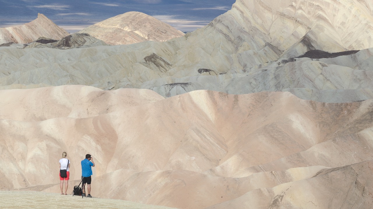
For anyone trying to plan a trip, the new reality is that Death Valley cannot be treated as a static destination where you book a room, circle a few highlights, and assume the roads will cooperate. The park’s own guidance now emphasizes that depending on where you wish to travel in the park, it may take longer than you expect, a polite way of saying that detours, slow zones, and outright dead ends are now part of the experience. That means itineraries built around sunrise at Zabriskie Point, a midday stop at Badwater Basin, and sunset at Dante’s View may no longer be feasible in a single day, especially if key connectors remain washed out or restricted to one-lane traffic controlled by flaggers.
The most practical advice I can offer, drawn directly from park messaging, is to Plan accordingly and to Visit the Deat conditions page before you commit to any long drives or backcountry excursions. The National Park Service has folded that guidance into its broader trip-planning tools, including a dedicated section on how to explore wildflowers that now doubles as a primer on road logistics, with a reminder that visitors should check up to date information on roads in the park before heading out. That blend of inspiration and caution is captured in the agency’s Depending on where you wish to travel guidance, which I see as a model for how parks can weave safety into the same narrative that draws people in.
Why this flood matters for climate risk in the American desert
Stepping back from the immediate closures, the record-breaking storm in Death Valley is a vivid case study in how climate extremes are reshaping even the most iconic American landscapes. A place that built its identity around heat and drought is now grappling with the consequences of intense, short-duration rainfall events that can rival coastal storms in their destructive power. When more than 1.75 inches of rain falls on terrain that has spent years baking under relentless sun, the result is not a gentle recharge of groundwater but a violent rearrangement of surface features, from alluvial fans to canyon mouths, and a stress test for every culvert and bridge that crosses a wash.
That pattern is not isolated to this one park, but Death Valley’s status as the driest place in North America makes it a particularly stark example of how the old mental maps of “wet” and “dry” regions are breaking down. The same data that confirm the 115-year record also hint at a future where such extremes become less of an outlier and more of a recurring challenge, forcing agencies to rethink design standards, maintenance schedules, and even the basic assumptions behind visitor safety messaging. Analyses of Death Valley climate and its surrounding region underscore how sensitive this desert is to shifts in atmospheric patterns, and I see the latest flood as both a warning and an opportunity to invest in more resilient infrastructure before the next storm arrives.
The geography behind the disaster: basins, canyons, and choke points
To understand why this storm caused such outsized damage, it helps to picture the park’s geography as a series of funnels and choke points that concentrate water into narrow corridors. Death Valley itself is a deep basin flanked by steep ranges, and when rain falls on those slopes, gravity does the rest, channeling runoff into canyons and washes that slice across the valley floor. Roads often follow or cross these natural pathways, which means that when a flood arrives, asphalt and gravel become just another layer of sediment for the water to rearrange, especially where culverts are undersized or clogged with debris from previous storms.
Specific areas within the park illustrate this dynamic in sharp relief. Routes that thread through tight canyons or skirt the edges of alluvial fans are particularly vulnerable, because even a modest rise in water level can turn a shallow crossing into a deep, fast-moving torrent that undercuts the roadbed from below. Mapping tools that highlight features like Death Valley basins and adjacent ranges show just how many of the park’s signature drives sit in the path of potential debris flows. When I overlay that mental map on the latest damage reports, it is clear that the storm did not hit randomly, it exploited every natural weakness in the terrain-road interface.
Communities and corridors around the park feeling the strain
The consequences of the flood do not stop at the park boundary, because Death Valley sits within a broader network of rural communities and travel corridors that depend on its roads for commerce and connectivity. When key entrances are closed or restricted, lodging in nearby towns sees cancellations, gas stations lose traffic, and tour operators have to scramble to redesign itineraries that once relied on predictable loops through the valley. For gateway communities that already operate on thin margins, a prolonged disruption in park access can turn a strong season into a financial stress test, especially if visitors decide to reroute entirely to other destinations in the Sierra Nevada or along the coast.
Regional mapping resources that track places like Furnace Creek and other hubs around Death Valley help illustrate how dependent these communities are on a handful of state and federal highways that feed into the park. When those arteries are compromised by flood damage inside the park, the ripple effects can include longer detours for residents, delayed deliveries, and more strain on alternative routes that were never designed for heavy traffic. In that sense, the record rainfall is not just a story about a national park, it is a stress test for the entire human footprint that has grown up around this extreme landscape.
Iconic sites, from Badwater to Scotty’s Castle, caught in the crossfire
Beyond the numbers and maps, the emotional weight of the storm comes from its impact on the specific places that define Death Valley in the public imagination. Visitors do not travel hours into the desert for an abstract experience of aridity, they come for concrete landmarks like Badwater Basin, Zabriskie Point, and the winding approach to Scotty’s Castle, each of which now sits within a web of damaged or at-risk roads. When those access routes are closed, the loss is not just logistical, it is symbolic, because it temporarily severs the connection between people and the stories embedded in those landscapes, from ancient lakebeds to early 20th century desert outposts.
Some of these sites were already dealing with the legacy of previous floods, and the latest record rainfall has compounded that burden. The corridor to Scotty’s Castle, for example, has faced repeated washouts that have delayed full reopening, and new damage to Scotty’s Castle Road only pushes that horizon further out. Mapping entries for Scotty’s Castle and surrounding routes highlight how isolated that corner of the park can become when a single road fails. As I weigh those realities, I am struck by how climate-driven extremes are slowly rewriting not just the physical landscape of Death Valley, but the very list of experiences that future visitors will be able to count on.
Using official tools to track a fast-changing situation
In an era when social media can amplify rumors faster than agencies can post updates, one of the most valuable tools for navigating Death Valley’s current disruption is still the park’s own digital infrastructure. The National Park Service maintains a central conditions page for Death Valley that consolidates Alerts, road status, and safety advisories into a single, regularly updated hub. That page now anchors its messaging around the fact that Many roads closed due to flooding on 11/18/2025, and it layers in details about which segments are open, which are under repair, and where visitors should expect delays or detours.
For travelers who want to go deeper, additional mapping and place-based resources can help visualize how those closures intersect with specific landmarks and routes. Entries that pinpoint locations such as Badwater Basin or Zabriskie Point can be cross-referenced with the park’s own Alerts & Conditions page to build a realistic picture of what is actually accessible on any given day. I find that combination of official status reports and geographic context essential for cutting through the noise and focusing on the facts that matter most: which roads are safe, which experiences are still possible, and how the park is slowly stitching itself back together after a storm that has already earned its place in Death Valley history.
More from MorningOverview