A high Andean plateau in Bolivia has turned out to be one of the most crowded dinosaur crossroads ever found, with at least 18,000 fossilized footprints pressed into a single slab of ancient shoreline. The newly documented tracksite does more than set records, it captures a moment when herds of different species converged on the same lake, leaving a layered story of movement, behavior, and survival written in stone.
By tracing those thousands of steps across the rock, paleontologists are reconstructing a lost ecosystem where sauropods, carnivores, and smaller plant‑eaters all jostled for access to water along a long-vanished coast. I see this site not just as a spectacular fossil bonanza, but as a rare, continuous record of how dinosaurs used a landscape over time, from daily commutes to what some researchers now describe as a continental “highway.”
The Bolivian plateau that became a dinosaur crossroads
The world’s largest dinosaur tracksite sits in the high country of central Bolivia, where an expanse of tilted rock forms a natural viewing platform over deep valleys and dry riverbeds. This is Torotoro National Park, a protected landscape of canyons and caves that now also includes the vast Carreras Pampa track field, a surface so densely stamped with prints that it reads like a traffic map from the Late Cretaceous. The setting is harsh and arid today, but the altitude and exposure make the tracks unusually easy to study in long, uninterrupted swaths.
Visitors who hike out across the plateau can walk beside the same shoreline where dinosaurs once trudged, following trackways that run for dozens of meters along what used to be a lake margin. The modern park infrastructure, including viewpoints and marked paths, has grown up around this fossil-rich terrain, and the Torotoro National Park setting is now central to how scientists and tourists alike experience the site. From this vantage point, the scale of Carreras Pampa becomes clear: a single rock surface, tilted like a giant billboard, carrying tens of thousands of steps from animals that once dominated South America.
Carreras Pampa and the leap from 16,600 to 18,000 tracks
When researchers first mapped Carreras Pampa in detail, they counted at least 16,600 individual footprints, enough to immediately crown it the most extensive dinosaur tracksite ever documented. That initial tally already shattered previous records for both the number of prints and the diversity of track types preserved in one place, turning this Bolivian plateau into a global reference point for dinosaur locomotion and behavior. The Carreras Pampas tracksite in Torotoro National Park, Bolivia, quickly became a benchmark for how much information a single surface of rock can hold about ancient life.
As field teams refined their surveys and extended mapping into adjacent panels, the footprint count climbed to roughly 18,000 tracks, a figure that reflects both the density of prints and the sheer area of exposed shoreline. The Carreras Pampa tracksite in Torotoro National Park in Bolivia is now described as the largest dinosaur tracksite in the world, with the 18,000 tracks estimate underscoring just how heavily trafficked this ancient lakeshore once was. That jump from 16,600 to 18,000 is not a rounding error, it is a sign that the more scientists look, the more overlapping journeys they find pressed into the mudstone.
A fossilized lakeshore and the lure of water
At the heart of Carreras Pampa is a long, gently sloping rock surface that was once the muddy edge of a lake, a place where animals came to drink, feed, and move between feeding grounds. The sheer preponderance of tracks suggests that this lake was a valuable resource for the animals living nearby, a focal point in a landscape that might otherwise have been seasonally dry or patchy in vegetation. Herds did not just pass through once, they returned often enough to stamp layer upon layer of footprints into the same stretch of shoreline.
Geologists working at the site describe a sequence of sedimentary layers that captured repeated wetting and drying cycles, ideal conditions for preserving footprints that were first impressed in soft mud and then quickly buried. The la of the ancient lake, with its fine-grained sediments and gentle slope, helped record everything from deep sauropod impressions to delicate three-toed prints from smaller dinosaurs, and the ancient Bolivian coastline setting explains why so many tracks overlap and intersect. In effect, the lake acted as both watering hole and recording device, archiving each visit in a new layer of silt that hardened into stone.
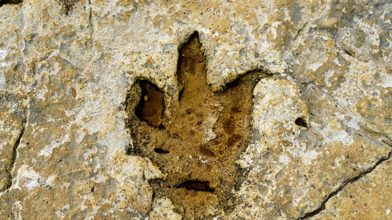
Who walked here: from giant sauropods to nimble carnivores
Reading Carreras Pampa is like watching a crowded wildlife documentary frozen mid-frame, with different dinosaur groups leaving distinct signatures in the mud. Large, round impressions with deep toe marks point to massive sauropods, whose column-like legs punched into the shoreline as they moved in groups along the water’s edge. Narrow, three-toed prints with sharp claw marks record the passage of theropod carnivores, some pacing alone, others moving in parallel paths that hint at coordinated behavior or shared hunting routes.
Mixed among these are smaller three-toed tracks from lighter plant‑eaters, likely ornithopods, whose shallower steps crisscross the heavier trails of the giants. Some trackways show tight clusters and overlapping paths, suggesting herds bunching together at the lake margin, while others form long, straight lines that cut across the surface like purposeful commutes. An expanse of ancient rock in the high-altitude Torotoro National Park in Bolivia has been revealed as the largest dinosaur tracksite yet identified, and the Torotoro National Park, Bolivia context helps explain why so many different dinosaur lineages converged here. The diversity of footprints turns the site into a census of who lived in and moved through this part of South America during the Late Cretaceous.
A “dinosaur freeway” across South America
One of the most intriguing ideas to emerge from Carreras Pampa is that it may represent just one busy junction along a much longer route that dinosaurs used to traverse the continent. Some researchers believe this region may once have formed part of a dinosaur freeway across South America, a corridor of favorable terrain and reliable water sources that funneled herds along similar paths over long distances. In that view, the Bolivian plateau was not an isolated oasis, but a key node in a broader network of migratory or seasonal movements.
The arid Carreras Pampa in Bolivia, with its extensive dinosaur tracksite, fits neatly into this hypothesis because it preserves not just isolated prints but long, continuous trackways that run in consistent directions. Those parallel paths suggest repeated use of the same routes, the fossil equivalent of ruts worn into a dirt road by generations of vehicles. The idea of a dinosaur freeway across South America is grounded in the density and orientation of these trackways, and the South America framing helps explain why paleontologists are now looking for similar track-rich surfaces in neighboring countries. If those connections can be mapped, Carreras Pampa could become the central piece in a continental puzzle of dinosaur movement.
World records written in stone
Beyond its narrative power, Carreras Pampa has quietly rewritten the record books for dinosaur trace fossils. The site holds at least 16,600 footprints that have been systematically cataloged, a figure that already set a world record for the most extensive dinosaur tracksite ever discovered before the count rose toward 18,000. That volume of data allows scientists to measure stride lengths, estimate speeds, and compare how different species navigated the same terrain, all from a single continuous surface.
The Carreras Pampas tracksite in Torotoro National Park, Bolivia, just smashed dinosaur track and trace records, with some individual prints stretching to impressive diameters and depths that reflect the size and weight of the animals that made them. Carreras Pampa is built on layers of sediment that captured everything from small tracks just a few centimeters across to massive impressions more than 80 cm found among the thousands, and the The Carreras Pampas record underscores how exceptional the preservation is. For paleontologists, those records are not just bragging rights, they are a statistical gold mine for testing ideas about dinosaur biomechanics and social behavior.
How mud, climate, and tectonics preserved 18,000 steps
To understand why Carreras Pampa holds so many clear footprints, it helps to look at the chain of geological luck that turned a muddy lakeshore into a fossil archive. First, the lake margin had to have the right consistency, wet enough to take a clear impression but firm enough that the print did not collapse under the animal’s weight. Then, new layers of silt and sand needed to wash in quickly, sealing the tracks before wind, waves, or scavengers could erase them. Over time, those stacked layers hardened into rock, preserving a vertical sequence of track-bearing surfaces that are now exposed side by side.
Later, tectonic forces lifted and tilted the entire package of sediments, raising the ancient shoreline high into the Andes and rotating it into a near-vertical wall that erosion could peel open. The result is an expanse of ancient rock in the high-altitude Torotoro National Park that presents the tracks almost like pages in an open book, each layer revealing a slightly different snapshot of the lake’s visitors. An expanse of ancient rock in the high-altitude Torotoro National Park in Bolivia has been revealed as the largest dinosaur tracksite yet identified, and the high-altitude exposure is a direct consequence of that tectonic uplift. Without that combination of mud chemistry, rapid burial, and mountain building, the 18,000 steps would have vanished long ago.
From local curiosity to global fascination
For people living around Torotoro, dinosaur tracks have long been part of the landscape, visible on tilted slabs and canyon walls that shepherds and farmers pass every day. What has changed is the scale of scientific attention and the way the site is now woven into Bolivia’s identity as a destination for deep-time tourism. As word of the tracksite’s size and scientific importance has spread, more visitors have begun making the journey to this remote corner of the Andes, turning Carreras Pampa into a focal point for both research and regional development.
Online, images of the rock wall packed with footprints have sparked intense curiosity, with thousands of people sharing photos, videos, and field reports that highlight just how surreal it is to stand beneath so many fossilized steps. An expanse of ancient rock in the high-altitude Torotoro National Park in Bolivia has been revealed as the largest dinosaur tracksite, and the Torotoro National Park, Bolivia story has resonated with audiences far beyond South America. I see that global fascination as a reminder that even in an era of high-tech telescopes and particle colliders, there is still something uniquely powerful about following a trail of footprints across a mountainside and realizing they were laid down by living animals more than 60 million years ago.
More from MorningOverview