For three days, a remote volcano off the Pacific Northwest coast has been shaking almost nonstop, a deep rumble beneath the ocean that has ricocheted across social media as a supposed warning shot for millions of people living from Seattle to Portland. The swarm of tremors has revived old fears about the region’s most dangerous peaks and raised a familiar question: how do we separate genuine hazard from viral hype when the ground starts to move?
I am watching this latest burst of seismic noise turn into a digital panic in real time, and the gap between what instruments show and what the internet claims is widening by the hour. The stakes are not abstract, because the Cascades and the offshore volcanoes really do sit within reach of major cities, but the science tells a more nuanced story than the breathless posts suggest.
What is actually rumbling beneath the Pacific Northwest
The current anxiety traces back to an underwater volcano in the northeast Pacific that has entered a sustained tremor phase, with instruments logging roughly 72 hours of near-continuous shaking. In technical terms, this kind of episode is usually a sign of magma or hot fluids moving through cracks in the crust, a reminder that the offshore volcanic system that parallels the Cascades is very much alive. The tremor is real, the location is real, and the pattern is consistent with a restless seafloor volcano rather than a distant tectonic quake.
Regional coverage has framed the feature as an undersea volcano in the Pacific Northwest that may be “getting ready to blow,” tying the tremor burst to a broader pattern of seismic unrest that also includes well known peaks like Mount St. Helens and Mount Rainier. Reports on the offshore activity describe a cluster of quakes and low frequency shaking that has persisted for days, with geologists tracking the swarm as it unfolds beneath the ocean between Washington and Oregon, close enough that any major event would matter for coastal communities but still far from the urban core inland. That framing, echoed in detailed explainers on an underwater volcano in the PNW, has become the seed for a much louder online narrative.
How a 72-hour tremor turned into a viral doomsday scenario
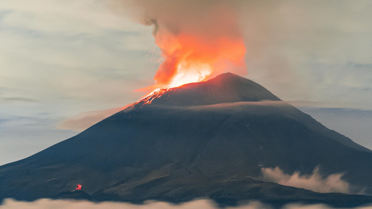
Once the tremor data began circulating, social media accounts quickly recast a technical bulletin into a countdown clock for a catastrophic eruption. Short clips and alarmist captions claimed that the offshore rumbling meant the “big one” was imminent, often stitching together images of Mount St. Helens, Mount Rainier and downtown skylines to imply that millions of people were directly in the blast zone. In that retelling, a localized undersea swarm morphed into a regionwide emergency, with little distinction between a submarine volcano and the snow covered cones that dominate the horizon.
Some of the most widely shared posts have leaned on dramatic language and sped up seismograph graphics, presenting the 72-hour tremor as unprecedented proof that the Pacific Northwest is on the verge of a chain reaction of eruptions. A popular Instagram reel, for example, pairs ominous music with captions warning that a high threat volcano system is “getting ready to blow,” using the offshore swarm as a hook to talk about the entire Cascades arc and drawing millions of views to a short viral eruption clip. In Facebook groups devoted to earthquakes and disasters, users have reposted the same graphics with added speculation about ashfall over Seattle and Portland, turning a complex geologic story into a simple, and misleading, doomsday script.
Mount Rainier, “America’s deadliest volcano,” and what the data show
Into this swirl of anxiety stepped a familiar character: Mount Rainier, often described as one of the most dangerous volcanoes in the United States because of its ice capped slopes and the dense population living downstream. As the offshore tremor gained attention, a separate wave of posts claimed that Rainier itself had entered a new, ominous phase, with some users insisting that the mountain was “about to erupt” and that authorities were hiding the truth. The narrative leaned heavily on Rainier’s reputation, treating the offshore swarm and the stratovolcano’s long term risk as if they were the same event.
Seismologists who actually monitor Rainier’s network of instruments have pushed back hard on that conflation, stressing that the viral claims about an imminent eruption are not supported by the data. The Pacific Northwest Seismic Network has publicly labeled the online warnings about “America’s deadliest volcano” as inaccurate, noting that the mountain’s seismicity remains within its normal background range and that no pattern of quakes, deformation or gas emissions points to magma rising toward the surface. That clarification, laid out in detail in a technical response to the viral eruption threat at Mount Rainier, underscores a key point: a noisy offshore volcano does not automatically mean Rainier is waking up, and the instruments on the mountain are not seeing the kind of changes that preceded past eruptions in the Cascades.
Record rumbling, high-threat volcanoes and what “alert” really means
Part of the confusion stems from the language used in early reports about the offshore swarm, which described a high threat volcano in Washington state rumbling at a record rate and mentioned that geologists had issued an alert. In scientific practice, an alert can be as simple as a notice to colleagues that an instrument is picking up unusual activity, not necessarily a public warning that an eruption is underway. When that nuance is lost, the word takes on a far more dramatic meaning in the public imagination than the scientists intended.
Coverage of the current episode notes that the tremor rate at this particular volcano is higher than what has been recorded in recent years, and that researchers have flagged the pattern for closer scrutiny. The same reporting explains that the volcano is classified as a high threat system because of its potential impact if it were to erupt, not because an eruption is guaranteed or overdue at this moment. In other words, the “record rate” and “alert” language reflect a technical assessment of risk and monitoring priorities, as described in detail in a piece on a high-threat volcano rumbling at a record rate, rather than a signal that millions of people should be evacuating coastal cities.
From offshore swarms to Cascade peaks: connecting, and misconnecting, the dots
As the story has spread, many posts have blurred the line between the undersea volcano and the iconic Cascade peaks that loom over the region. Some videos and articles jump directly from the 72-hour tremor to sweeping claims that Mount St. Helens, Mount Rainier and other volcanoes are all “getting ready to blow,” as if the entire arc were a single, synchronized system. That framing resonates emotionally, especially for residents who remember the 1980 eruption of Mount St. Helens, but it glosses over the fact that each volcano has its own plumbing, its own monitoring network and its own behavior.
Several outlets have leaned into that dramatic arc, describing the offshore swarm as part of a broader pattern of unrest that could, in theory, involve multiple volcanoes, while also noting that scientists have not seen the specific warning signs that would indicate a chain of imminent eruptions. One widely shared explainer on the undersea activity explicitly links the swarm to concerns about St. Helens and Rainier, but it also quotes geologists who emphasize that the current data do not show magma moving toward the surface at those peaks. That tension, between the attention grabbing suggestion that the “big one” might be coming and the more measured scientific view, is evident in both a national write up of the underwater volcano and the big one and in local TV segments that try to balance public concern with expert caution.
Mount Adams and the quiet work of volcano monitoring
While the offshore tremor and Rainier’s reputation dominate the headlines, another Cascade giant has quietly entered the conversation: Mount Adams in southern Washington. Recent reporting notes that scientists have been pulled from work at this high threat volcano, not because it is erupting, but because limited resources and shifting priorities have forced agencies to make hard choices about where to focus their monitoring efforts. The decision highlights a less visible side of volcano science, where budgets and staffing can shape how closely each peak is watched, even in a region with multiple high consequence hazards.
Mount Adams is classified as a high threat volcano because of its size, its history and its proximity to communities in Washington and Oregon, yet it has long been overshadowed by its more famous neighbors. The report on scientists being reassigned from Adams underscores that, even as public attention swings wildly from one viral scare to the next, the day to day work of maintaining instruments, analyzing data and updating hazard maps is often stretched thin. That reality is laid out in coverage of how Mount Adams pulls scientists from a high-threat volcano, a story that sits in stark contrast to the online impression that every mountain is under round the clock, high resolution surveillance.
Social media, “deadliest volcano” labels and the risk of crying wolf
The phrase “America’s deadliest volcano” has become a kind of shorthand in this debate, a label that is technically rooted in hazard assessments but often used online as a scare tactic. In the current cycle, that label has been attached to Mount Rainier in posts that claim the mountain is entering a dangerous tremor phase, even though the instruments do not show the kind of escalating seismicity that would precede an eruption. The gap between the label and the data is where misinformation thrives, because a mountain that is genuinely capable of deadly lahars and ashfall can be portrayed as an immediate threat without any supporting evidence.
Several national and international outlets have seized on the “deadliest volcano” framing to describe the broader situation in the Pacific Northwest, sometimes pairing it with references to a tremor phase and the possibility of an eruption. One widely read piece describes a high risk volcano entering a tremor phase that could, in theory, precede an eruption, while also quoting experts who caution that such phases can occur without any surface activity at all. That nuance is often lost when the story is repackaged on social media, where screenshots of the phrase “deadliest volcano” circulate without the surrounding context. The dynamic is evident in a detailed write up on an America’s deadliest volcano tremor phase, which has been widely shared in forums that focus more on the headline than on the careful caveats inside the article.
Inside the online echo chamber: Facebook groups, YouTube breakdowns and Yahoo recaps
To understand how the 72-hour tremor story has evolved, it helps to look inside the online spaces where it is being discussed. In large Facebook groups devoted to earthquakes, volcanoes and “prepping,” users have posted screenshots of seismograms, maps of the Cascades and clips from local news, often layering their own commentary on top. Some posts urge people in Seattle and Portland to stock up on supplies and prepare for ashfall, while others share links to more measured explainers that try to separate fact from fear. The result is an echo chamber where the most dramatic interpretations tend to rise to the top, even when calmer voices are present. One such group thread, which has circulated maps of the offshore swarm alongside speculation about Rainier and St. Helens, can be seen in a widely shared Facebook discussion about the volcano threat.
YouTube has become another key amplifier, with creators posting long breakdowns of the tremor data, often mixing genuine seismology with conjecture about what might happen next. Some channels walk viewers through the raw waveforms and explain how tremor differs from discrete earthquakes, while others lean heavily on dramatic thumbnails and titles that promise insider knowledge about an impending eruption. One video that has drawn significant attention dissects the recent swarm, overlays it with maps of the Cascades and speculates about possible scenarios if multiple volcanoes were to awaken in sequence. That kind of content, exemplified by a detailed YouTube analysis of the rumbling volcano, can be informative when grounded in data, but it also illustrates how easily complex science can be reframed as entertainment.
What scientists say about risk, readiness and the next eruption
Amid the noise, the core scientific message has remained consistent: the Pacific Northwest is a volcanically active region, and another eruption somewhere in the arc is inevitable over long timescales, but the current 72-hour offshore tremor does not mean that millions of people are in immediate danger. Seismologists emphasize that true precursors to eruptions usually involve a combination of signals, including sustained increases in local earthquakes, measurable ground deformation and changes in gas emissions, none of which have been reported at the major Cascade peaks in connection with this swarm. The offshore volcano is restless, and it deserves close monitoring, but the data do not support the idea that a catastrophic, multi-volcano event is underway.
At the same time, experts argue that the public’s interest in these stories can be harnessed to improve real preparedness, if the conversation shifts from speculative countdowns to practical steps. That means using the current attention to remind residents in lahar zones to know their evacuation routes, encouraging coastal communities to stay informed about tsunami and ashfall plans, and pressing policymakers to fund the monitoring networks that make early warnings possible. National recaps of the situation, including a widely shared Yahoo overview of the viral eruption threat, highlight that tension between fear and readiness, noting that while the most alarming claims are not backed by evidence, the underlying hazards are real and demand sustained, sober planning rather than short bursts of panic.
Living with restless ground without surrendering to panic
For people who live in the shadow of the Cascades or along the Pacific coast, the idea that a volcano can rumble for 72 hours without warning is understandably unsettling. The images of ash plumes, pyroclastic flows and lahar filled valleys are not distant memories in this region, and the knowledge that another eruption will eventually come is part of the local psyche. The challenge is learning to live with that reality without letting every tremor, every viral clip and every dramatic headline dictate our sense of safety.
In my view, the path forward lies in insisting on clear, data driven communication from scientists and newsrooms, and in cultivating a healthy skepticism toward content that treats complex geologic processes as simple countdowns to disaster. That means paying attention to official monitoring networks, understanding what terms like “tremor phase” and “high threat” actually mean, and recognizing that a restless offshore volcano is a reminder to stay prepared, not a guarantee that the worst case scenario is about to unfold. The Pacific Northwest’s volcanoes will continue to rumble, sometimes for hours or days at a time, but our response does not have to swing between complacency and panic if we ground it in the best available evidence, including careful technical assessments such as the geologists’ alert about record rumbling and the Pacific Northwest Seismic Network’s detailed rebuttal of the most extreme claims.
More from MorningOverview