A newly mapped fracture beneath an urban volcano has sharpened long-standing fears about how modern cities cope with geologic risk. The discovery of this deep structural break, running directly under a densely populated area, has forced scientists and local officials to reassess what they thought they knew about the volcano’s plumbing and the vulnerability of the people living above it.
Instead of a tidy, centralized magma chamber, researchers now see a more fragmented system in which molten rock can exploit hidden weaknesses in the crust. That picture complicates everything from hazard maps to evacuation plans, and it raises urgent questions about how quickly city infrastructure, health systems and information networks can adapt when the ground itself is less stable than anyone realized.
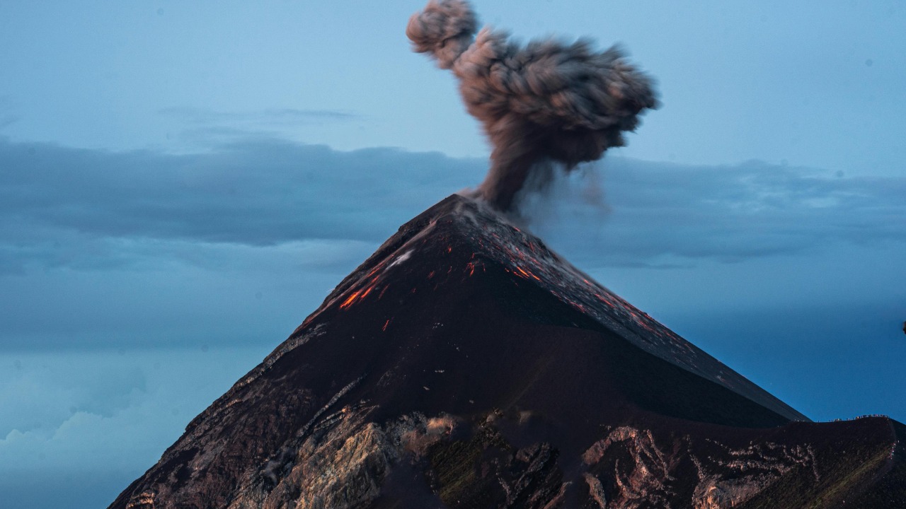
The hidden fracture beneath a living city
The core finding is stark: high‑resolution imaging has revealed a large structural crack beneath an active volcanic complex that sits directly under a modern city. Scientists used a combination of seismic data and subsurface modeling to trace this feature, which appears to cut through older rock layers and connect zones of magma storage at depth with shallower pathways closer to the surface. The geometry suggests a potential conduit that could channel pressure and fluids in ways that were not accounted for in earlier hazard assessments, a shift that has been underscored in recent reporting on the newly identified subsurface crack.
What makes this fracture so unsettling is not only its size but its location beneath dense housing, transport corridors and critical services. Urban planners often assume that the most dangerous volcanic structures are obvious cones or calderas on the skyline, yet the new imaging shows that key weaknesses can be buried and invisible until sophisticated surveys reveal them. That mismatch between what residents see and what scientists now know is driving a push for more transparent risk communication and for updated land‑use rules that reflect the volcano’s true footprint beneath the city.
How scientists mapped a threat no one could see
To understand how such a major feature went unnoticed for so long, it helps to look at the tools that finally brought it into focus. Researchers combined dense arrays of seismometers with advanced signal processing to track how small earthquakes and background vibrations moved through the crust, then inverted those signals to build a three‑dimensional model of the subsurface. The resulting image showed a sharp contrast in rock properties along the fracture zone, consistent with a long, deep crack that can transmit fluids and stress differently from the surrounding rock, a pattern that aligns with how digital traces can reveal hidden structures in other complex systems, as detailed in technical work on low‑level data analysis.
Once the fracture emerged in the models, teams cross‑checked it against historical seismicity, ground deformation and gas measurements to see whether it had been influencing the volcano’s behavior all along. That retrospective analysis suggested that past swarms of small quakes and subtle uplift episodes clustered along the same corridor, hinting that the crack has been active for years, if not decades. The lesson is that raw data alone is not enough; only when scientists apply more sophisticated algorithms and revisit older records with fresh questions do these hidden patterns become visible, a dynamic that mirrors how large digital archives, such as the curated web‑scale collections in the FineWeb‑pro dataset, can yield new insights when reanalyzed with improved methods.
Urban life on a restless foundation
For residents, the revelation that a major structural weakness runs beneath their streets reframes everyday routines. Housing blocks, schools and hospitals that once seemed safely distant from the volcano’s visible summit are now understood to sit atop a potential pathway for magma, gas and hot fluids. That does not mean an eruption is imminent, but it does change how risk is distributed across neighborhoods, particularly in older districts where building standards were set long before modern geophysical surveys existed. Community groups that have long campaigned for better air quality, safer housing and more resilient infrastructure now find that their arguments extend below the surface as well, echoing the way citizen advocates in port cities have linked environmental and social vulnerability in detailed reports on urban health and housing.
Living above an active volcanic system also magnifies existing inequalities. Wealthier residents can more easily retrofit homes, buy insurance or relocate if hazard maps are redrawn, while low‑income families are more likely to remain in the most exposed zones. Public health professionals have warned that environmental threats rarely fall evenly across a city, and that chronic stress from pollution, noise and overcrowding can leave some communities less able to cope with acute shocks. That perspective is central to modern frameworks in environmental health in nursing, which emphasize that physical hazards like volcanic gases or ash interact with social determinants such as housing quality, access to care and baseline respiratory health.
Health, ash and the invisible fallout
Even without a dramatic eruption, a deep fracture that connects magma to shallower levels can change the way gases and heat leak into the urban environment. Volcanic systems routinely emit sulfur dioxide, carbon dioxide and fine particles that can seep through faults and fractures, sometimes pooling in low‑lying areas or infiltrating basements and underground spaces. For people with asthma, cardiovascular disease or other chronic conditions, even modest increases in these pollutants can trigger serious health episodes, a pattern that environmental clinicians have documented in other settings where air quality and geology intersect, and that aligns with the broader evidence base summarized in nursing‑focused work on environmental exposures.
Health systems in the city now face a dual challenge: they must prepare for the acute surge in injuries and respiratory problems that would accompany any ashfall, while also monitoring the slower, less visible impacts of chronic gas emissions along the fracture zone. That means integrating geophysical data into hospital planning, so that clinics in the most exposed neighborhoods can stock appropriate medications, protective equipment and filtration systems. It also requires clear communication with residents about when to stay indoors, how to seal homes against ash and what symptoms should prompt immediate medical attention, a communication task that is complicated by the fragmented and sometimes misleading flow of information in the digital age, as explored in analyses of how data overload can obscure critical signals in works like Blown to Bits.
Information, rumor and the digital fault lines
As news of the subsurface crack spread, the first wave of public reaction did not unfold in town halls or official briefings but on social platforms where residents shared maps, personal anecdotes and, in some cases, unverified claims. Local groups quickly circulated posts that mixed genuine concern with speculation about worst‑case scenarios, illustrating how community‑level forums can both amplify legitimate questions and inadvertently spread confusion. One widely shared discussion in a neighborhood group, captured in a public social media thread, shows residents trying to reconcile scientific jargon with their lived experience of minor tremors and occasional sulfur smells.
For scientists and emergency managers, that online conversation is both a resource and a risk. It offers real‑time insight into what people are seeing and fearing on the ground, but it also creates pressure to respond quickly in spaces where nuance is hard to sustain. The broader challenge mirrors what media scholars have observed in other high‑stakes contexts: when complex technical information meets fragmented attention and algorithmic feeds, clear messaging can fracture along the same lines as the physical fault beneath the city. That is why some research institutions now invest in training scientists to communicate across disciplines and platforms, a trend reflected in university programs that blend science, policy and public discourse, such as the interdisciplinary initiatives described in institutional documents from Ashoka University.
Planning for the next tremor, not the perfect forecast
City officials now face a familiar but sharpened dilemma: they must act on incomplete information, knowing that the fracture has changed the risk landscape but not knowing exactly how or when that risk will manifest. The history of disaster management shows that waiting for perfect certainty is rarely an option, particularly in dense urban settings where evacuation logistics are complex and infrastructure is aging. Planners are revisiting zoning rules, transport contingencies and shelter locations with an eye to the newly mapped weakness, much as earlier generations of civic leaders had to rethink their assumptions after unexpected shocks, a pattern that can be traced in archival records of how communities adapted to disruptive events in documents like the early twentieth‑century Polo Monthly, which chronicled social and logistical adjustments in the wake of war and pandemic.
In practical terms, that means stress‑testing evacuation routes that cross the fracture zone, assessing whether key bridges, tunnels and utility corridors could withstand intensified shaking, and identifying backup sites for critical services if certain districts become temporarily uninhabitable. It also means acknowledging that volcanic risk is not a single scenario but a spectrum, ranging from minor gas releases to ashfall to more severe eruptive activity. Emergency plans that focus only on the most dramatic outcome can leave the city underprepared for the more likely, lower‑level disruptions that still carry serious economic and health costs. Historical accounts of how communities have lived with recurring natural hazards, such as the detailed field notes and observations preserved in digitized volumes of Natural History, suggest that incremental adaptation, rather than one‑time fixes, is the most realistic path.
What the crack reveals about our relationship with risk
The discovery of a massive fracture beneath an urban volcano is not just a geological surprise; it is a mirror held up to the way modern societies build, govern and share knowledge. For decades, the city grew outward and upward on the assumption that the most serious volcanic dangers were confined to a visible cone and a set of well‑mapped lava flows. The new imaging shows that the real system is more intricate and less predictable, with hidden structures that can channel energy in unexpected ways. That realization echoes a broader pattern in how humans confront complex systems, from financial markets to digital networks, where unseen connections can suddenly become decisive, as technologists have noted when grappling with the cascading effects of interconnected data infrastructures in works like Blown to Bits.
In response, the city has an opportunity to rethink its relationship with the volcano beneath it, not as a distant backdrop but as an active partner in planning. That means embedding geoscience into everyday governance, from building codes to school curricula, and treating local knowledge as a complement to, not a substitute for, technical expertise. It also means recognizing that the same analytical tools used to map the fracture can be turned outward, helping residents understand other hidden systems that shape their lives, whether in the form of environmental exposures, digital footprints or social networks. As researchers refine their models and assemble ever larger datasets, much as data scientists curate expansive corpora like the FineWeb‑pro collection, the challenge will be to ensure that those insights translate into concrete protections for the people living above the crack, not just more detailed maps of the risks they face.
More from MorningOverview